High-tech scouting from NOAA provides a detailed new look at old South Jersey structure.
There are many wrecks to fish off Sea Isle and Ocean City, far more than we knew about when I grew up on the South Jersey shore when dead reckoning was how we found things, aided by a flasher depth sounder. Except for the head boats and big sportfishermen who could afford Loran, finding charted offshore wrecks was hit or miss, mostly miss. But more wrecks have been found since then and others have been more precisely charted.
Affordable Global Positioning System electronics have made getting on these wrecks possible for even casual recreational fishermen. And although government multibeam sonar imaging is limited for most South Jersey waters, there is partial multibeam and side-scan sonar survey coverage for Townsends and Hereford Inlets and for a narrow band along the shoreline. Where this coverage isn’t available, it’s still possible to learn enough about an area to put boats on good structure using various National Oceanic and Atmospheric Administration (NOAA) sonar, wreck, and obstruction data resources.
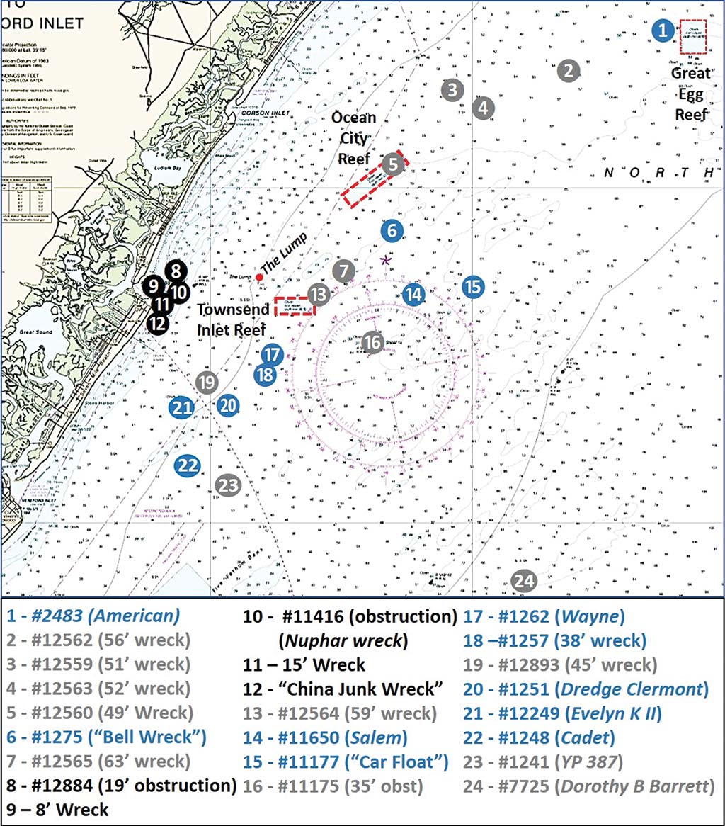
Side-scan sonar-like imaging covering the inlet entrances and wrecks and obstructions shown in black on Chart 1 can be viewed using the NOAA Bathymetric Data Viewer (BDV). Record numbers from the Coast Survey’s Automated Wreck and Obstruction Information System (AWOIS) are shown as available. Although no longer updated, AWOIS remains a valuable online reference for scouting bottom structure. When using it, click on a wreck or obstruction icon. A pop-up box displays information developed from notices to mariners, discrepancy reports, and field surveys for that feature. Data accuracy and completeness vary.
Upon Further Review
Features shown in blue on Chart 1 offer substantial bottom structure. For example, Site #1, AWOIS #2483, is an iron tank barge that sank in 1925. The charted location coincides with a large dimple that appears on the BDV “DEM” Color Shaded Relief image at 39° 14.690N / 74° 22.837W. The dimple displays under the wreck circle shown by a see-through raster navigation chart layer. The structures shown in grey may also have fishable structure, but the available sonar imagery wasn’t sufficient to correlate reported locations and descriptions with sounding data, as is the case for Sites #2 to #4.
The Ocean City and Townsends Inlet Reefs have considerable reef deposits consisting mostly of concrete castings and rubble, Reef Balls, Army tanks (OC Reef), and small commercial vessels. Reef types and coordinates for all but the most recent placements are well-documented by the New Jersey Reef Program guide (njfishandwildlife.com). These reefs and surrounding bottom provide a range of fishing opportunities for sea bass, tautog, flounder, and other sportfish.
The largest structure in these two reef sites is the 195-foot hopper barge Libra located in the northeast corner of Ocean City Reef where a BDV “DEM” Color Relief Image shows a very distinct “dimple” at coordinates 39° 10.798N / 74° 32.769W. AWOIS #12560, a 49-foot wreck shown as Site #5 on Chart 1, is within the reef boundary. It’s probably the Libra, but there are several other vessels nearby.
The BDV “DEM” Color Shaded Relief image for Ocean City Reef shows a number of dimples, though none were distinct enough to correlate with the New Jersey reef program grid. Not to worry, however, if you use Navionics charts. Many of the individual reefs were entered into the Community Layer and correlate with the geographic coordinates included in the reef program guide. The Community Layer annotations and contour lines are especially helpful for the Townsends Inlet Reef for which “DEM” image data show minimal bottom anomalies (Chart 3).
The lack of bottom dimples suggests that the sounding data from field surveys predates the reef deposits. Note that Community Layer entries are ad hoc and unverified as to accuracy and veracity. So, treat them as an information resource with undetermined and variable error factor.
A Ghost Returns
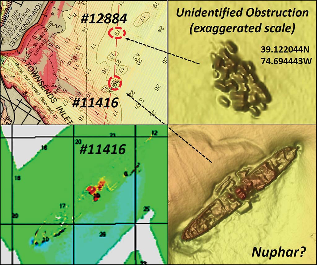
A large shipwreck at the mouth of Townsends Inlet was featured in Ghost of Nuphar (The Fisherman, NJ/Delaware Bay edition, March 2020), the very first in the BDV Spotlight series. The wreck, Site #10, was originally reported as an obstruction in 1975 and recorded in AWOIS as Record Number 11416 at 39° 06.910N / 74° 41.667W. The fact that it is a wreck which supposedly had been removed is not recorded in AWOIS.
Chart 2 includes a color multibeam sonar image of the wreck, which closely matches the description and dimensions of the Nuphar. The image was taken from National Ocean Service (NOS) Descriptive Report (DR) H11019 (2002) which identified the structure as a wreck. The feature is less well defined in this color multibeam image than in a BDV “BAG” Color Shaded Relief image that was derived from multibeam sonar data collected during a 2014 hydrographic survey documented by NOS DR H12599.
Six-plus decades ago, there was minimal shoreline protection and the Townsend Inlet shoals continually shifted position. The inner bar on the north side was always there, although its shape would change frequently. The outer bar and channel openings through the bar moved around a lot. Sometimes we would go out one day and find that the channel had shifted to a new location from the previous day. I don’t know how many times we saw the channel buoy laying on its side on top of the bar! Most of the time, we had to work our way out around the northeast corner of Avalon, at times almost a mile down the coast.
Years later, Avalon installed rock shoreline protection including rock jetties along the north end of the island. This created a permanent southern boundary for the inlet. Later, a jetty was built out from the southeast corner of Ludlam Island across a near-shore slough. It was usually too shallow to pass through this slough. Once in a while, a nor’easter would blow out the slough. We sometimes could sneak through in a 13-foot Boston Whaler in the fall to troll for blues when northwesterly wind conditions kept the surface flat and the breakers down.
The combined effects of the jetty on the north side and the shore protection structures on the south side “trained” the inlet discharge. More consistent ebb current flow helps keep the channel open. The Nuphar is on the northeast edge of the outer bar just north of the channel where sometimes a channel would cut through. This made it easier to get our 30-foot skiff to the inshore 8-foot tautog wreck at Site #9. We would line up shore structures to position the boat over the wreck. Sometimes current boils would reveal its location. Once when the current caused turbulent boils, we observed large tautog actually breaking the surface showing their entire heads out of the water! Wreck coordinates are 39° 07.110N / 74° 42.133W.
New Look At Old Haunts
Although Nuphar was there – albeit completely sanded in and hidden – another feature most likely wasn’t there. Site #8, a charted 16-foot obstruction to the north/northwest (AWOIS #12884) has the characteristics of a deliberately constructed artificial reef Over 25 objects similar in size and shape are placed in a tight cluster, as shown on Chart 2. This reef is about 60 by 35 feet in length and width with an estimated 3 feet or so of vertical relief at 39° 07.318N / 74° 41.664W.
The BDV “BAG” Color Shaded Relief image clearly shows the objects, but the definition isn’t sufficient to reveal what is there. The derivation isn’t indicated in NOS DR H12599 which documented the survey that found it. Anecdotally, these are old refrigerators dumped to create a fishing spot, an unpermitted “bandit” artificial reef.
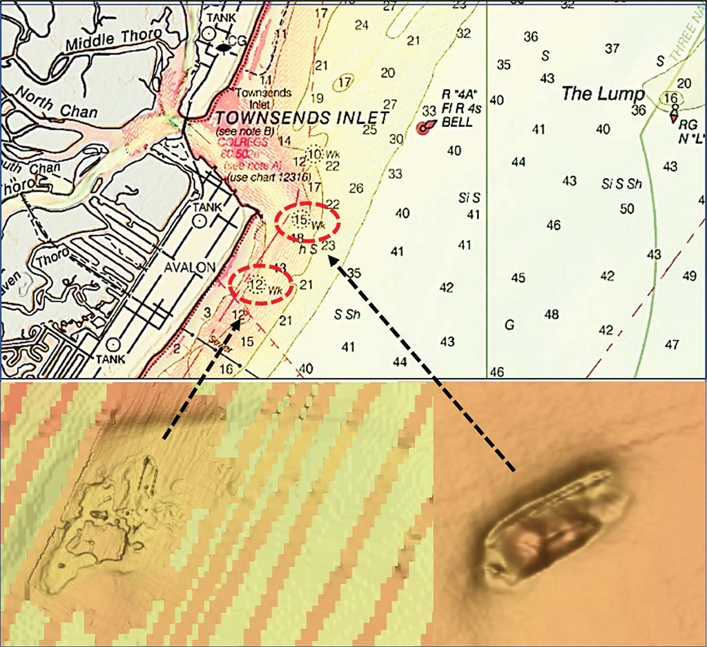
Other wrecks we didn’t know about were the 15-foot wreck (Site #11) and the 12-foot wreck (Site #12), the latter known as the China Junk Wreck for the artifacts retrieved by recreational divers. Archeologists frown on such practices and also on anchoring in wrecks due to anchor-caused damage and the loss of historical artifacts. Although the latter wreckage is widely distributed, there’s a lot there to drift through. Best not to put an anchor (and risk losing the hook) directly in a wreck. Snagged artifacts should be turned over to appropriate State historical authorities.
Chart 3 shows an enhanced “BAG” Color Shaded Relief images of both wrecks. Site #11 is at 39° 06.395N / 74° 41.820W. It’s right in the inlet discharge channel, about where the outer bar was during my youth. Best guess is that the changed inlet current pattern swept sand from over the wreck. The China Junk wreck is distributed around 39° 05.887N / 74° 42.272W.
Another interesting feature is AWOIS #1275, a 48-foot wreck known as the Bell Wreck located at Site #6. Although recorded as a small wreck, it is reported to have 11 feet of vertical relief. There is a large dimple in the “DEM” Color Shaded Relief image at 39° 08.706N / 74° 33.258W. AWOIS #11650 at Site #14 is described as a barge that is 220 feet long with 8-foot high sides. This may be the schooner barge Salem which is shown at this approximate location by njscuba.net. Many a proud sailing ship ended their careers as hulls stripped down for barge service. So, when scouting barge wrecks with the BDV or on the water with recreational sonars, knowledge of what hull form is there provides valuable insight.
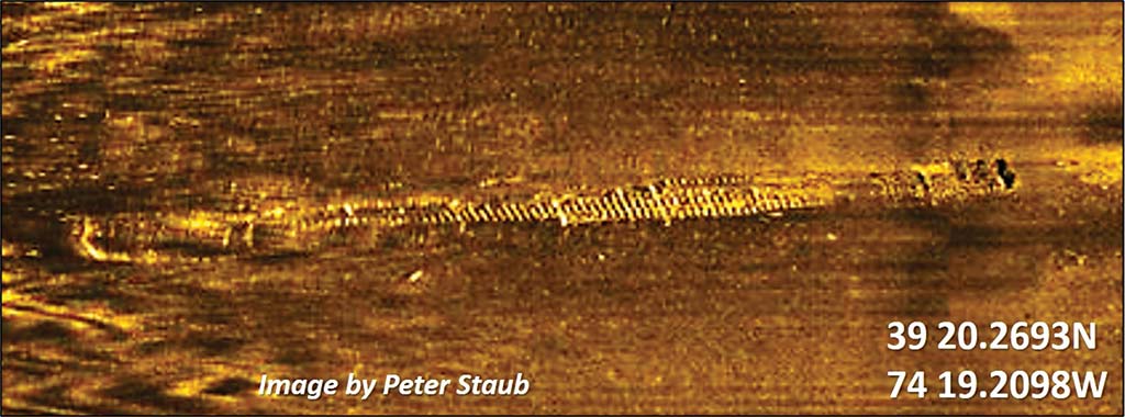
AWOIS #11177, located at 39° 06.991N / 74° 30.096W (Site #15), is a very large wreck. The feature is described by a diver report as a 270- by 25-foot rail barge and referred to as the Car Float that was carrying boxcars when it was lost. Wheels and undercarriages are close to the wreckage. There are two Car Float wrecks in South Jersey waters. The location recorded by AWOIS is a long distance from the location of another Car Float, AWOIS #1322, off Absecon Inlet. The latter’s position is consistent with the location shown by njscuba.net and the coordinates of a side-scan sonar screenshot by Peter Straub of the Stockton University’s Marine Science Program.
However, the AWOIS description of #11177 and the description on the university’s website for the wreckage shown by the Staub sonar image, AWOIS #1322, are very similar. The “DEM” Color Shaded Relief image east of OC Reef shows a broad dimple on the bottom, indicating that something large is there. If it is a car float, it would probably be a long, narrow barge similar to #11177 shown by Image 1. It’s large and may be worth checking out.
Reading Dimples
Slightly southwest of southwest corner of Townsend Inlet Reef at a distance of 1.3 NM is the 41-foot wreck of the barge Wayne, AWOIS #1262, at Site #17. There’s a modest “DEM” dimple at 39° 05.014N / 74° 37.767W. It was reported to have high ribs and a pilothouse. About 0.6 NM southwest of the Wayne is a 38-foot wreck, AWOIS #1257, at Site #18. It is marked by a “DEM” dimple at 39° 04.423N / 74° 38.059W.
Southwest of the Townsends Inlet Reef about 3.1 NM lies AWOIS #1251, a 22-foot wreck in 40 feet of water at Site #20. The wreck, first recorded in 1943 with 10 feet of clearance, has deteriorated since then. It’s approximately where njscuba.net puts the wreck of the early, very large dredge Clermont. The “DEM” image for this wreck shows a pronounced dimple at 39° 03.497N / 74° 39.400W. Whatever lies there is substantial. It’s a short run from either Townsends or Hereford Inlet, and worth checking out for sea bass and tautog.
Site # 22, AWOIS #1248, is a 22-foot wreck listed as the Cadet. Located at 39° 03.497N / 74° 39.402W where there is a “DEM” image dimple, it’s possibly a broken up derrick barge. Site #23, AWOIS #1241, is YP 387. This 102-foot long, 22-foot beam converted trawler, referred to as a “yippie” boat, was used as a patrol vessel. It was lost to a marine casualty in 1942 at 39° 01.210N / 74° 39.264W. No dimple for this one, or for Site #24, AWOIS #7725, which is the wreck of the five-masted schooner Dorothy Barrett. This 259-foot-long, 45-foot beam sailing vessel was in the coal trade. U-117 sank the schooner by gunfire in 1918.
There’s certainly a lot more structure outside of Townsends, Corsons, and Great Egg Harbor Inlets than what we knew about way back when. Modern technology provides the capability to quickly find these wrecks and obstructions, and knowing what to look for in advance can help target new fishing destinations along the coast.
Wayne Young is a former manager of the Maryland artificial reef program for Chesapeake Bay waters. He is the author of “Chesapeake Bay Fishing Reefs: Voyages of Rediscovery” available on Amazon.com. His Facebook page is Chesapeake Bay Fishing Reefs. Charts and bathymetry images are processed screenshots from the National Oceanic and Atmospheric Administration’s Bathymetric Data Viewer which can be found at https://maps.ngdc.noaa.gov/viewers/bathymetry.