Our “Bathymetric Data Viewer” series continues in 2021 with a closer look at the “bunker” strewn waters around Sandy Hook.
Seacoast fortifications along the Eastern Seaboard have a history longer than the nation itself. New York Harbor was perhaps the most fortified of any port. Governors Island has two forts (Fort Jay and Castle Williams) and a battery (later site of the First Army, and subsequently Coast Guard, Officers Club). The Battery in Lower Manhattan has Castle Clinton. By the Verrazzano-Narrows Bridge in Brooklyn is Fort Hamilton and the Caponiers, a sub-fort that guarded the main fort from waterside attacks.
Guarding the eastern entrance to the East River from Long Island Sound is Fort Schuyler at Throggs Neck. Fort Totten sits across from it in the Bronx. Sandy Hook had Fort Gates, and later Fort Hancock. These early fortifications were built for harbor defense.
World War I and II saw various coastal surveillance structures and fortifications bolstered by Coast Guard beach patrols (some on horseback!) Later there were NIKE sites. Some of the East Coast fortification structures are still with us today, albeit abandoned, such as a concrete watch tower at Cape May Point and a huge concrete battery at Cape May. Immediately in front of the old watch tower is the wreck of the concrete ship Atlantus (see “Discovering Atlantus” in the March, 2020 edition of The Fisherman).
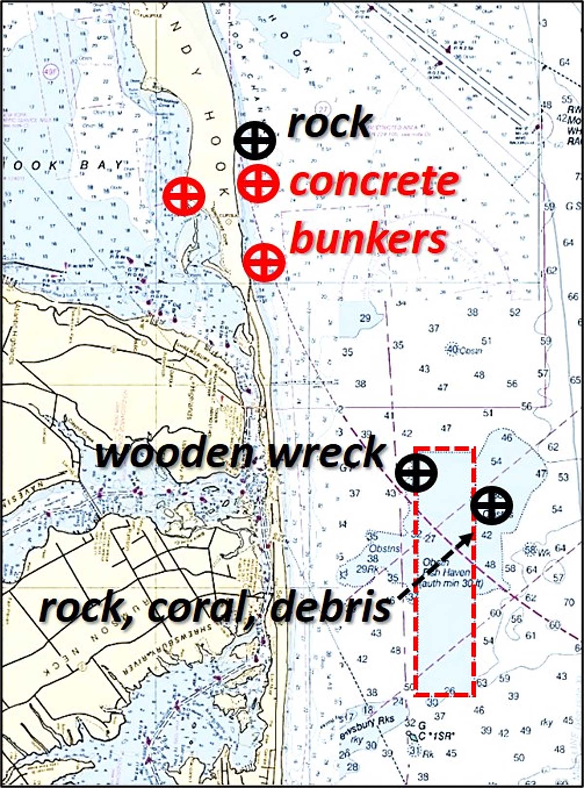
At Sandy Hook, there was Fort Hancock and a number of batteries and magazines. Some of these structures fell to erosion and became shoreline obstructions. Others became or are becoming bottom structure, unintentional artificial reefs. Such is the case with four concrete bunkers on the east and west side of the Sandy Hook access road. Approximate locations are shown in CHART 1.
Avant-Garde Angling
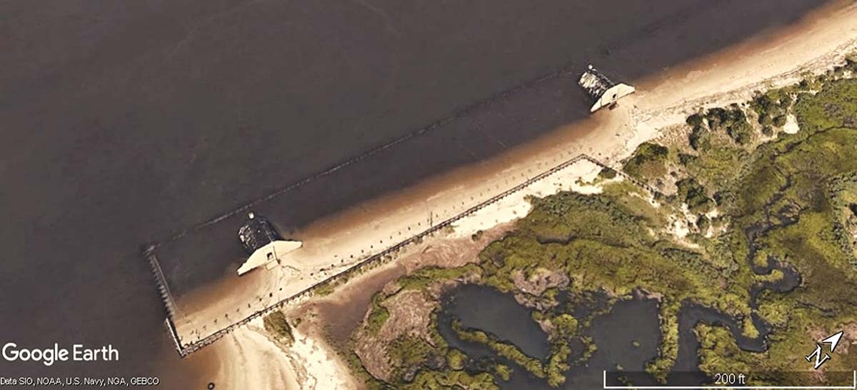
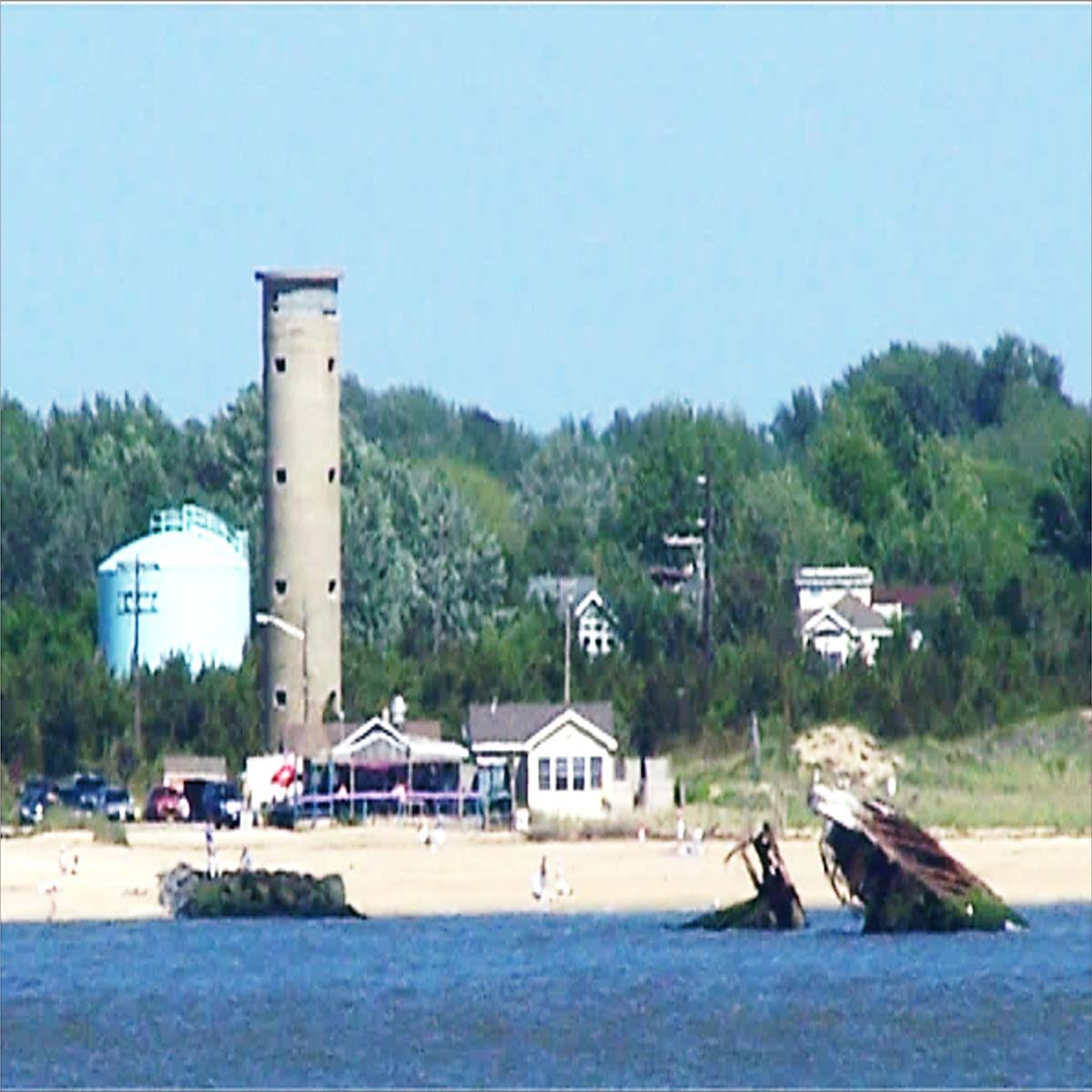
Located on the Sandy Hook Bay shoreline west of Horseshoe Cove Marsh at Battery Arrowsmith are two concrete bunkers. These structures are shown behind a bulkhead on dry land as late as 2002 in aerial photographs and satellite images accessed using the Google Earth Pro historical images feature. By 2006, the bulkhead had been compromised. The sand fill had eroded eastward, exposing the western end of the bunkers to Sandy Hook Bay. Now, the water’s edge is at the east end of the structures. The bunkers, which contain some bizarre paintings, became sort of an avant-garde art gallery garnering attention from the news media. Erosion is taking its toll. The western ends of the bunkers are settling and water has penetrated the interior and scouring occurs around the foundation. The bunkers will eventually be completely taken by the bay and convert into unintended fishing reefs.
Two concrete bunker remains on the east side are already serving as unintentional fishing reefs. One is located under an obstruction circle centered at 40° 25 15.06N 73° 58 50.03W. This object, Automated Wreck and Obstruction Information System (AWOIS) Record #4741, is reported as a section of a submerged concrete bunker that measures 9 feet by 8 feet with a vertical rise of 6 feet. Least depth is charted as 2 feet.
This particular feature does not show in the National Oceanic and Atmospheric Administration’s (NOAA) Bathymetric Data Viewer (BDV) “BAG” Color Shaded Relief image. When investigated for a chart update, it was 60 feet offshore. Sitting this close to a dynamic beach, its distance offshore will vary as conditions change. At this writing, it’s about 200 yards offshore; that’s a significant way off in terms of surfcasting, but try casting in that direction anyway (there are still a few significant groins along the Sandy Hook stretch). If local conditions allow, casting to the structure from a boat lying off the beach may be an option. The other two are submerged, visible as shadows in recent satellite images. Check Google Earth for locations.
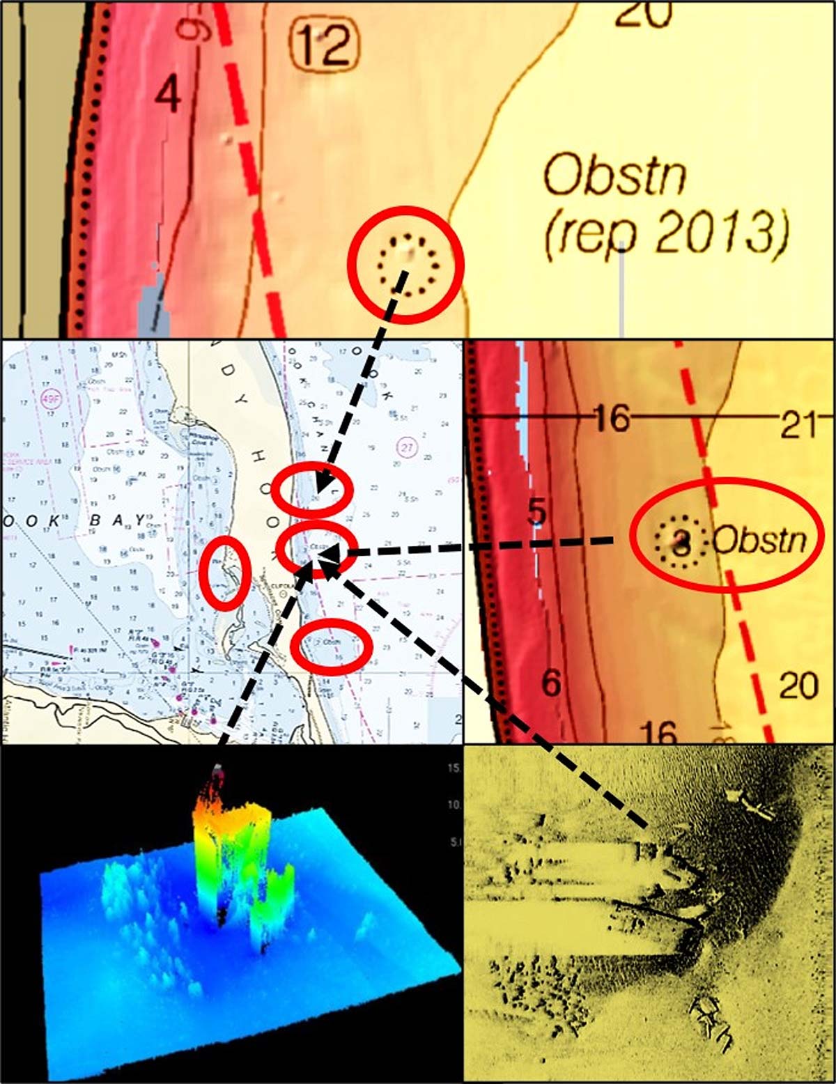
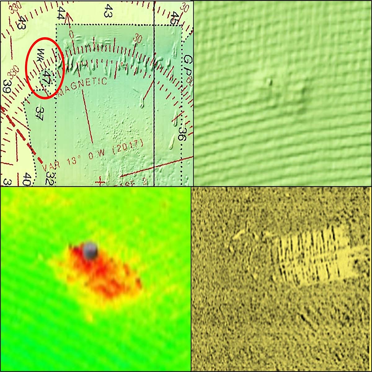
The most significant structure, AWOIS Record #4742, is about 1,400 yards further north, due east of Nike Pond at 40° 25 55.48N / 73° 58 51.64W. Local residents reported a bunker off Highlands Beach to NOAA circa 1982. The feature was reported awash at low tide and was investigated by NOAA divers in 1987. They found a submerged concrete bunker with a slight list but stable. They also found it surrounded by rubble. The bunker measured 15 by 25 feet with a vertical relief up to 18 feet. Least depth was charted as 2 feet in 1987, and is now charted as 3 feet. A 2006 survey team was not able to obtain a complete side-scan sonar image due to shallow depth of water. However, the feature was “ensonified” using several sonar devices according to NOS Descriptive Report H12608 (2014). The sonar image was included in the report along with a CARIS 3D image as seen in CHART 2. The additional material in H12608 shows a concrete face typical of bunkers is broken off and lying in pieces at the end closest to shore, which is part of the reported rubble.
This bunker does not appear in historical aerial photographs as far back as 1945 or in satellite images using Google Earth Pro. An Internet search yielded no historical information about their origin. Best guess is that the bunkers date back to World War I and the neck of land was much wider then than now. All that aside, the bunker is covered by the BDV “BAG” Color Shaded Relief image at right middle in CHART 2. It is slightly to the left center of the charted obstruction circle, and about 650 feet offshore as this is written. However, the shoreline is dynamic, and clearance distance to the water’s edge is subject to change. The additional insight gained from H12608 reveals this structure is worthy of fishing attention where possible.
Color Shaded Relief
Another obstruction was reported in 2013. It is located about 200 yards north of the bunkers and about 200 yards offshore at 40° 26.244N / 75° 58.830W. The feature is charted as an obstruction without further characterization. It is visible in the upper BDV “BAG” Color Shaded Relief image in CHART 2. Hook False Channel, which runs towards the north northwest just offshore, provides a natural trough for bait and prey movement. All of these structures and natural bathymetry provide good inshore fishing opportunity from boats, and are also attractive for surf fishing.
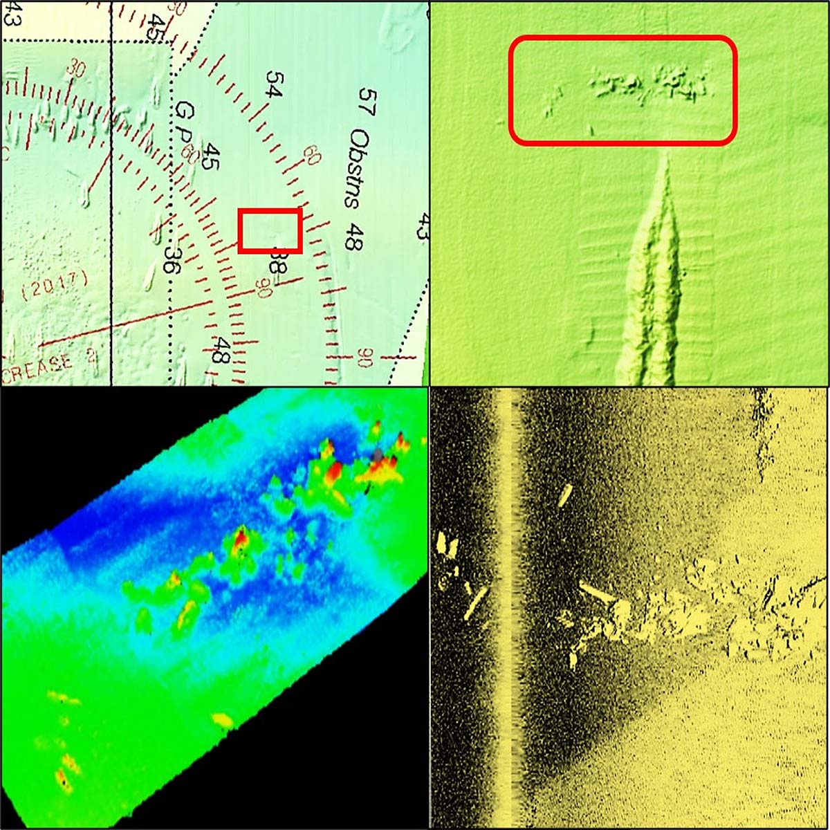
NOS Descriptive Report H12608 also includes several interesting feature images in proximity to Sandy Hook Reef as shown in CHART 1. One of these is AWOIS Record #8076. It is the old, badly weathered, unidentified wooden wreck shown in CHART 3. Divers investigated and found ribs and framing, but no planks. They also found what they thought might be a gunnel with a mooring cleat. Sonar data indicates a square wreck. Comparing the CARIS 3D and side-scan sonar images from H12608 with the BDV ”BAG” Color Shaded Relief image, the former shows that the wreckage is more rugged than what otherwise appears as a grainy mound in the latter. The feature is worth checking out when in the area.
H12608 also includes AWOIS Record #8072 which is located at 40° 22-56.32N / 73° 55-33.42W. The feature is described as a shoal east of Sandy Hook Reef that is about 110 yards long and 25 yards wide and possibly composed of rock or corals. The report also notes that imagery records debris-like characteristics. The materials are oriented east/west and by shape are more consistent with a debris field rather than rock or corals. The feature is immediately north of the north end of a deliberately discharged, elongated pile of dredged material, possibly consisting of rock. Vertical relief of the debris field is not stated, but it presents a low profile in the images in CHART 4. The Descriptive Report images aid in assessing the structure as more likely manmade than natural, the narrative from the report notwithstanding.
When sportfish are working bait along the shoreline or during striper migration, the area along the beach offers a nice combination of natural and manmade features to check out. If the area is cold, run due east of the southernmost bunker remnant about 3,000 yards to a large dredged borrow area. Sandy Hook Reef, a modest 2.5 mile run 139 degrees true from the bunker, has a massive array of structure both inside and outside of the permitted reef boundary.
Knowledge of the history of the structure and use of modern electronics to identify the range of natural and manmade features provides ample opportunities for trolling, casting, jigging, and bottom fishing.
Wayne Young is a former manager of the Maryland artificial reef program for Chesapeake Bay waters. He is the author of “Chesapeake Bay Fishing Reefs: Voyages of Rediscovery” available on Amazon.com. His Facebook page is Chesapeake Bay Fishing Reefs. Charts and bathymetry images are processed screenshots from the National Oceanic and Atmospheric Administration’s Bathymetric Data Viewer which can be found at https://maps.ngdc.noaa.gov/viewers/bathymetry.