A square mile oasis of structure off the Atlantic County coast.
Great Egg Reef has a lot of little “eggs” or in this case, reef balls. There are also a goodly number of Army tanks along with various concrete castings spread out in patches across the reef site. The center of the reef is about a 9 nautical mile run east southeast from Great Egg Inlet and 6.5 nautical mile run southeast of Absecon Inlet. There are also a number of wrecks that lie between the shoreline and Great Egg Reef and the Atlantic City Reef which provide structure for bottom fishing.
As with all of the New Jersey ocean artificial reefs, someone has entered most, if not all, of the reef structures listed in the New Jersey Reef Guide into the Navionics Community Layer as a “fishing facility” (fish inside a circle icon). It you use the Navionics card in your electronic navigation chart, steering to the icons will put you close. Or, click on the icon for approximate coordinates. The same information can be viewed online using the Navionics web app.
Catch My Drift
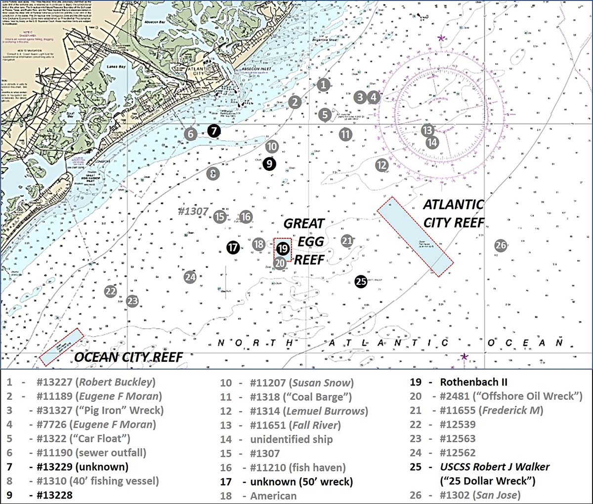
Great Egg Reef’s layout, small size of reef units, and ocean setting makes it challenging to find and set up over individual reefs, electronic charting aids notwithstanding. Drifting through the reef site with bottom rigs may be the better fishing option. An exception is the 165-foot tank barge YON-96, known as the Rothenbach II after one of the sponsors, the Rothenbach family (the U.S. Navy was the other sponsor). The hulk is large enough to find using electronic charts or coordinates and recreational side-scan sonars. A deployment picture taken as explosive charges were detonated to sink the barge is posted on njscuba.net.
The Great Egg Reef is outside of “BAG” Color Shaded Relief imaging. However, the general texture of bottom bathymetry is shown by “DEM” Color Shaded Relief images using the National Oceanographic and Atmospheric Administration (NOAA) Bathymetric Data Viewer (BDV). Sonar imaging for some wrecks is available from the National Ocean Service (NOS) Descriptive Report (DR) H11198 (2003). These wrecks are labeled in red on the main image at the top of the feature. The numbers shown behind vessel identification are the Coast Survey’s Automated Wreck and Obstruction Information System (AWOIS) record numbers.

Rothenbach II Reef is the large dimple in the middle of the reef site shown in Chart 1. Although side-scan sonar coverage is not published for this wreck, the three-dimensional color image of multibeam sonar data shown in Chart 1 was included in DR H11198. The barge appears intact as of the date of the image.
Immediately south of the southern edge of the reef site is an unidentified 53-foot wreck known locally as the “Offshore Oil Wreck”. The vessel is thought to be a World War I tanker based on anecdotal information from a diver that is recorded in AWOIS. Absent sonar images, the extent of wreckage and its condition are not known. But, if fishing the reef site, it’s worth looking at it and several nearby charted obstructions to see if anything is there.
Just west of the reef boundary, another large dimple is shown by the “DEM” image. This is the 53-foot wreck of iron tank barge American, AWOIS #2483. Sonar images were not included in the DR. Although the vessel had been converted into a tank barge, don’t look for a rectangular hull form. The American was a 218-foot by 23-foot, three-mast private yacht with a clipper-like hull and bowsprit and a low-profile pilothouse amidships. A picture of the vessel while serving as a yacht is shown on njscuba.net.
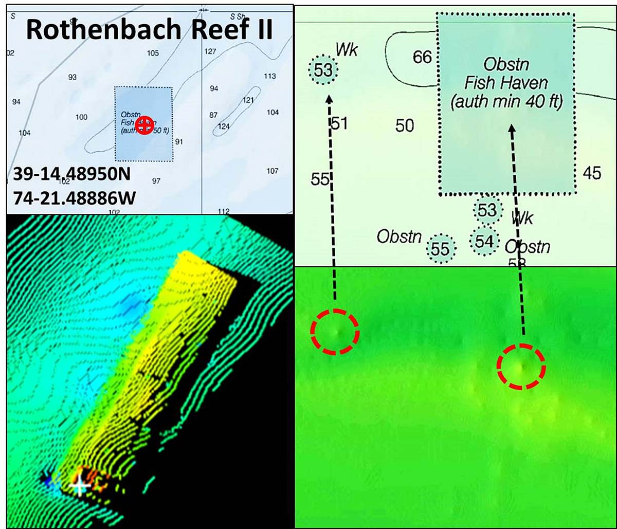
An unidentified 50-foot wreck is located just west of the American. Chart 2 includes a 3D color image of the wreck and several side-scan sonar images. The hulk appears mostly buried. But don’t pass it by. There’s enough shown for a drift through or two when hunting fish in and around the reef site.
Off The Grids
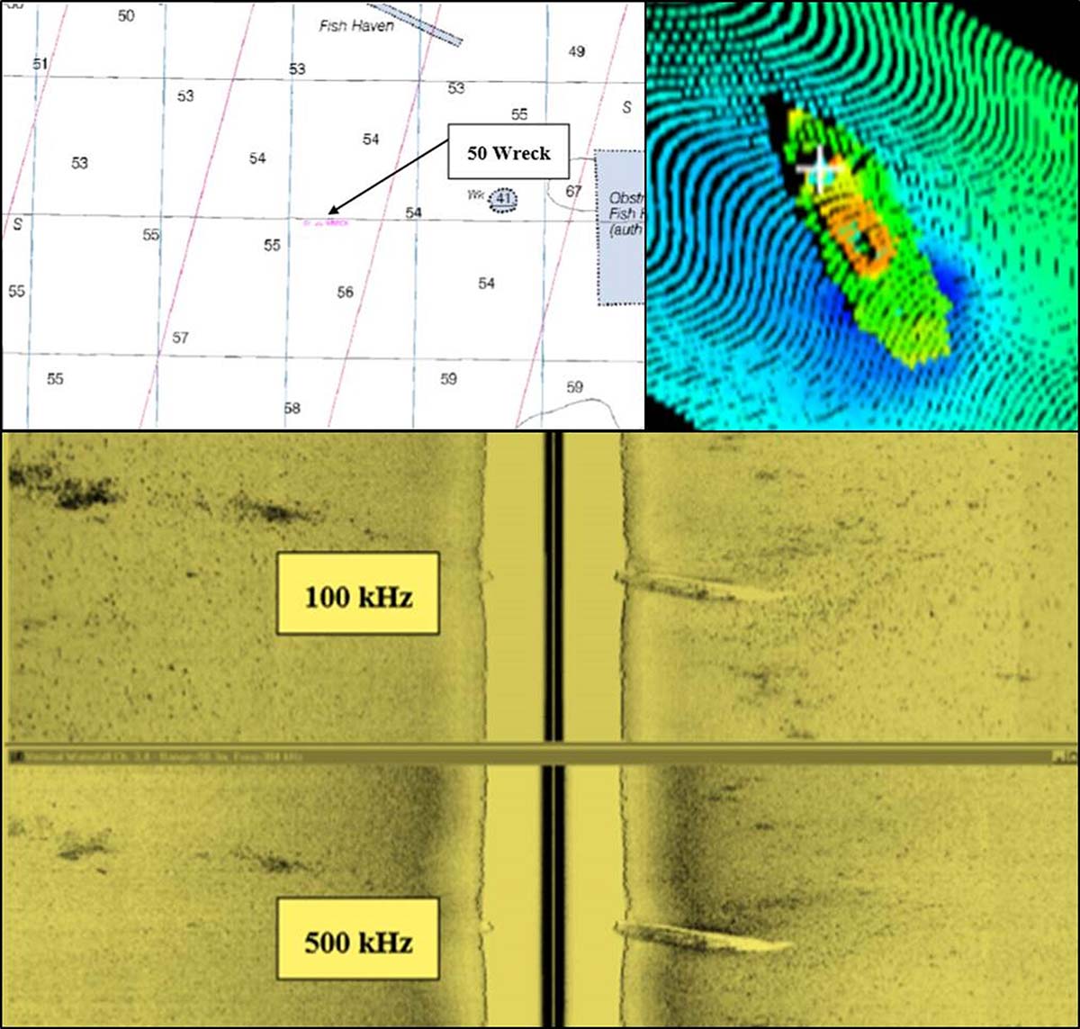
There are number of wrecks to check out within several miles of Absecon Inlet for those who don’t want to run offshore. Most are outside of BDV side-scan sonar-like coverage. Wrecks close to shore such as these are in the high energy zone and prone to being covered by shifting sands and deterioration from effects of storm waves. An example is AWOIS #13229 shown by Chart 3. A color image of multibeam sonar data and a side-scan sonar image were featured in DR H11198. Although only fragments of the wreck remain, its low profile may reduce the potential for snags when drifting through.
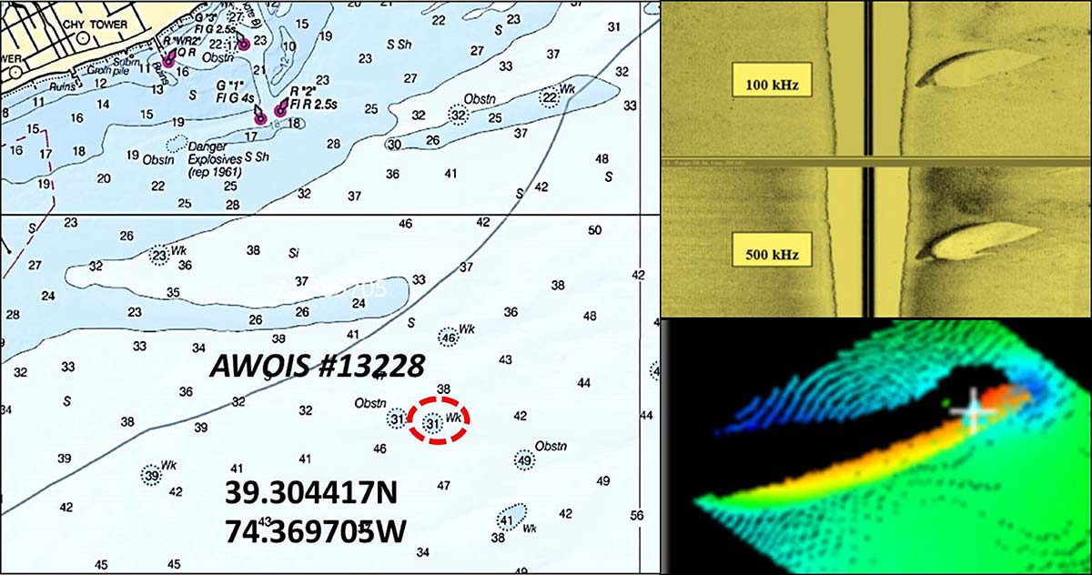
A little further offshore straight out from the inlet is the wreck of the fishing vessel Susan Snow, AWOIS #11207. Although no description is reported, she mostly likely was a clammer considering her “Snow” name. There’s no condition report in AWOIS data or the DR. Just east of Susan Snow is AWOIS #13228, another unidentified wreck. However, this one was featured in DR H11198. Although the hull is not characterized, the profile resembles a sailing vessel by appearance in the 3D color and side-scan sonar images included in Chart 4. The hull appears to be intact and listing to one side. Again, the condition shown was in 2003, and storm conditions since then may have affected the wreck and site conditions.
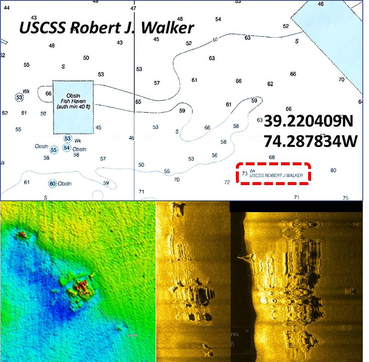
Closing out this look at wrecks off Atlantic City is the U.S. Coast Survey steamer Robert J. Walker, lost to a collision in 1860. Built in 1847 as a 133- x 31-foot steam-driven paddlewheel cutter for the Revenue Cutter Service, the ship proved too slow for offshore revenue enforcement operations. The ship was transferred to the Coast Survey where it served ably in hydrographic survey service. The ship collided at night with a schooner during a gale and sank with a loss of 20 men plus another crewman who later died from injuries. Before salvage work was ordered, the Civil War intervened. Without a salvage attempt, the wreck’s location was lost to history until a commercial fisherman found it in the 1970s. The fisherman sold the coordinates for $25, from which the wreck became known as the $25 Wreck.
With steamboat machinery scattered on the bottom, the wreck became a favorite dive site, but vessel identify remained a mystery until 2013. Drawing on diver reports, a NOAA hydrographic survey and follow-up diver investigation after Super Storm Sandy positively identified the wreckage as that of the USCSS Robert J. Walker. The wreck was added to the National Register of Historic Places by the National Park Service in 2014.
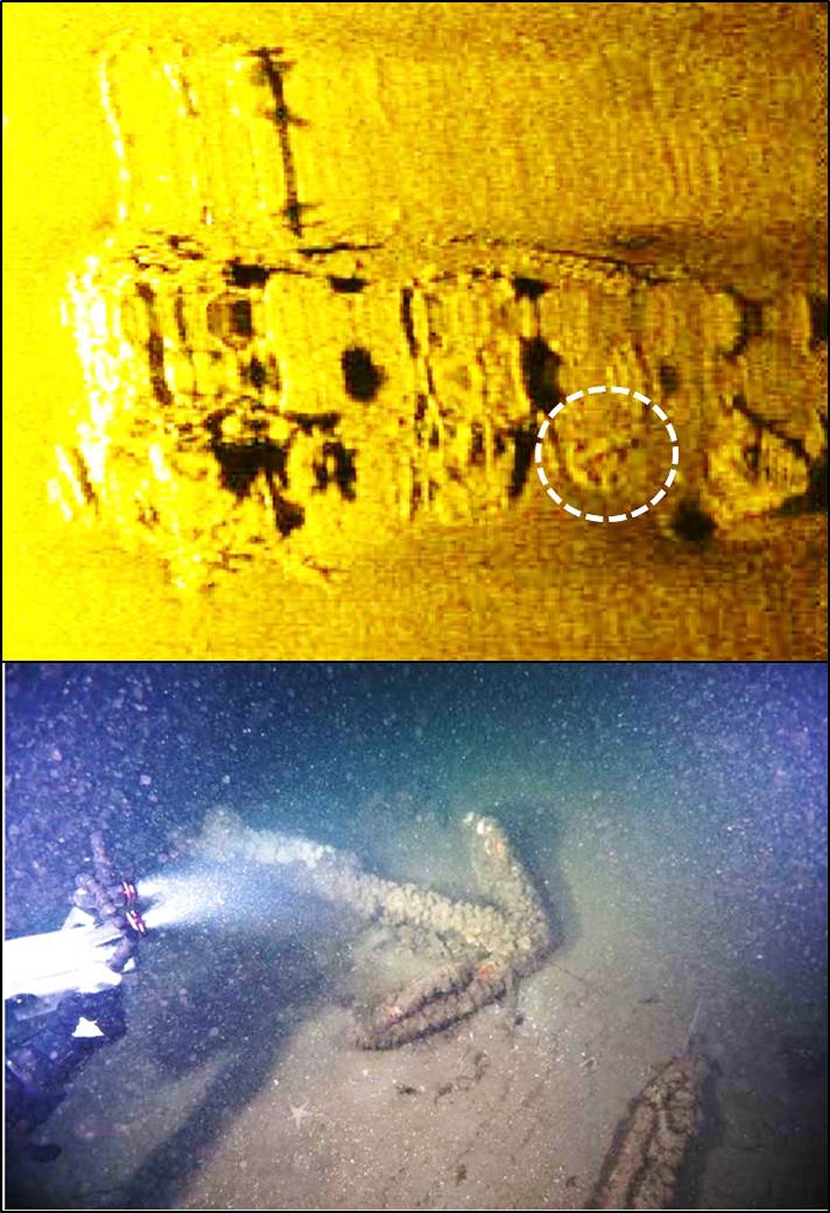
A 2013 NOAA report, from which this account is taken, is available on line, as is a conference paper for a diving symposium the same year (see Identification of the Wreck of the U.S.C.S.S. Robert J. Walker Off Atlantic City, New Jersey, Delgado, 2013), NOAA Office of National Marine Sanctuaries). Both contain side-scan sonar images, underwater photographs, and drawings. See also njscuba.net and Wikipedia. The wreck is located between the Great Egg and Atlantic City Reefs as shown in Chart 5. Among the artifacts are two anchors, one lodged under bow wreckage and one visible on deck in side-scan sonar images. A screenshot from the NOAA survey showing the latter is shown in Chart 6.
Recreational fishermen departing Great Egg or Absecon Inlets have no shortage of bottom structure to target. Options include going northeast to the wrecks off Brigantine, southeasterly to the wrecks off Atlantic City and the Atlantic City and Great Egg Reefs, or southwest to wrecks off Ocean City and the Ocean City Reef. Back in the day when I was growing up on the Jersey shore, running offshore outside of the sight of land was a navigation adventure. Even with track lines on our charts, navigation error of a mile or more was not uncommon after chasing schools of bluefish or being offset by unseen ocean currents. Fast boats and electronic navigation charts fed by Global Positioning System data and have made those offshore runs quicker and more accurate.
Even so, always have a chart or chart book with track lines on board as a backup. Also, prepare and leave a float plan with someone you can trust to file a report with the Coast Guard if you’re overdue on returning, and notify your “trusted agent” when you safely arrive at the dock or ramp.
Wayne Young is a former manager of the Maryland artificial reef program for Chesapeake Bay waters. He is the author of “Chesapeake Bay Fishing Reefs: Voyages of Rediscovery” available on Amazon.com. His Facebook page is Chesapeake Bay Fishing Reefs. Charts and bathymetry images are processed screenshots from the National Oceanic and Atmospheric Administration’s Bathymetric Data Viewer which can be found at https://maps.ngdc.noaa.gov/viewers/bathymetry.