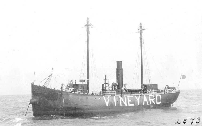
In this month’s feature articles, you undoubtedly read the article by Charley Soares on the Vineyard Sound Lightship. As always, Charley covered the subject quite well mixing historical information with his own accounts of hunting for and eventually fishing on the wreck with the late Tim Coleman.
In researching the spot, as I so often do when I receive an article which lists a wreck as I find the history behind such stories quite interesting, I came across some information published by the Massachusetts Board of Underwater Archaeological Resources (BUAR). BUAR is, “…the sole trustee of the Commonwealth’s underwater cultural heritage and is charged with encouraging the discovery, reporting, interpretation, and protection of these resources. While underwater archaeological resources are commonly shipwrecks (there are more than 3,500 shipwrecks within Massachusetts waters), they also include submerged Native American sites, wharves, and aircraft.”
BUAR currently designates 40 sites as exempted status, of which the Vineyard Sound Lightship is included. Exempted status designation means “an underwater archaeological resource, because of its location, condition, history, or resource value is best left in the public domain.” These exempted sites allow for, “Recreational diving activities, including casual artifact collection, on exempted shipwreck sites,” and they do not require a permit from BUAR.
While readers of The Fisherman aren’t necessarily concerned with the ability to dive a given wreck site, although some do, the same data of interest to divers is of great importance to us as anglers both in how the site is located as well as what fish might be attached to the structure and how it can be fished.
The following comes from the BUAR listing for the Vineyard Sound Lightship.

VESSEL DETAILS
Description: Lightship; steel
Dimensions: Length – 123 feet, 9 inches. Width – 28 feet, 6 inches. Depth – 14 feet, 9 inches
Tonnage: Displacement – 693
Propulsion: Steam propeller; rigged with auxiliary sail when built
Machinery: Single 400 indicated horsepower compound engine
THE SHIPWRECK
Date Sunk: September 14, 1944
Cause: Hurricane
Location: Roughly three miles west of Cuttyhunk Island
Coordinates: Latitude, 41° 23′ 47.40″ N; Longitude, 71° 01′ 12.60″ W
DIVE SITE CONDITIONS
Depth in feet: maximum – 80; minimum – 46
Visibility in feet: Average
When first investigated in 1963 by Brad Luther and members of the Fairhaven Divers Club, the bow and stern of the lightship were intact. The main deck had deteriorated exposing the second deck and sand, filtering into the engine room, had blocked access. At that time, the ship’s binnacle and compass were recovered.