Using the NCEI Bathymetric Data Viewer for local ghost hunting.
Editor’s Note: In the fall of ’25 we received an email from Paul Ruzga asking about the “ghost ships” along the Staten Island side of the Elizabeth River. In this NCEI Bathymetric Data Viewer scouting report, author Wayne Young delves into these shadowy ruins. -JH
Arthur Kill shared by New Jersey and New York harbors provide urban recreational fishing destinations, notwithstanding industrialized shorelines. There are a lot of modern structural features, older piers – some of which are obsolete or in ruins – and an enormous number of wrecks. Species found include striped bass, white perch, gizzard shad, and American eel. Plus, New Jersey’s Rahway River tributary is a well-known freshwater fishing destination above tidal influence.
Tidal tributaries to this waterway suffered environmentally due to industrial activities, and in the case of Fresh Kills, trash disposal. Morses Creek sediment, for example, was heavily contaminated from petrochemical runoff. Access to this creek, a future remediation site, is cutoff by a water control structure. Today, some of the tributaries are on the mend through restoration measures; a prime example being the ongoing, long-term transition of the Fresh Kills landfill on the Staten Island side to public parkland.
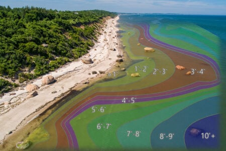
As for fishing structure, highly deteriorated, obsolete, abandoned vessels are found at multiple locations in this waterway, mostly along on the New York side. Wrecks, pier ruins, and a few rock piles provide marine habitat and are also fishing and paddling destinations. General locations for many of these features are shown on Chart 1.

Online Recon
Armchair scouting these features from north to south in Chart 1 begins with Site 1 at the mouth of the Elizabeth River. Look for a wreck listed as File Number 12552 in Coast Survey’s former Automated Wreck and Obstruction Information System (AWOIS). Although no longer maintained, this database is nevertheless a valuable repository of historical information about structure. For this recorded wreck, submerged remnants of an old wooden vessel are along the north side of the entrance.
Site 2 marks railroad bridge piers and fender walls which protect the bridge from vessel strikes. Immediately south of the bridge on the east side are the skeletal remains of a wood pier. A low rockpile at its eastern end falls bare at low tide. The entrance to Morses Creek is red flagged as Site 4 due to contaminated sediment. Barge landings are on either side of the entrance. Skeletal ruins of a platform is centered between the landings. A low road and low railroad bridge near the entrance are in ruins. Best to avoid fishing the entrance in view of the contamination effects on fishes unless doing catch and release. Across the Kill just to the south at Site 5, there’s a barge landing area. Try casting to a series of concrete mooring caissons connected by a wooden pier parallel to the shoreline.
Moving south to Site 6, look for a subsurface landing ruin at coordinates 40° 37.381N / 74° 12.298W. No piling are visible. Instead, the feature shown by the upper left insert on Chart 1 has the appearance of a collapsed deck. This feature is about 200 feet long, is oriented east-west, and uncovers at very low water. It’s sometimes marked by disturbed water as current interacts with it. Try casting to the structure for stripers later this spring.
The mouth of Rahway River is marked by a green dot as Site 7. This 24-mile long river is a natural jewel in a largely manmade landscape. The lower section of the river is tidal and characterized by tidal marshes sand mudflats. The river is tidal up to Rahway. It’s navigable from the entrance for about three miles by small powerboats. Charted depths end before the Interstate 95 (New Jersey Turnpike) Bridge. Note that there is also some tug and barge traffic on the lower river. The non-tidal freshwater river has numerous access points and natural settings in an otherwise urbanized landscape. The non-tidal river is a freshwater fishing destination throughout and upper portions are stocked with trout in the spring.
Just inside the river entrance, look for two freestanding concrete piers to cast to or jig. Along the north shore, watch out for riprap shoreline protection that juts out and uncovers at very low water. The feature is marked by a yellow arrow on the middle left insert of Chart 1. Try casting over the rocks for stripers when current is on the feature. Site 8 is the location of a railroad bridge and four I-95 Bridges. The railroad bridge piers are protected by cribbing. There are two long fender walls under the I-95 Bridges.
Back out in Arthur Kill along the Staten Island shoreline, look for a rockpile at Site 9 in coordinates 40° 35.102N / 74° 12.313W. There are three piers ruins just to the north consisting of broken off piling. Of these structures, the rockpile in the most promising. Site 10 marks Great Fresh Kills and the developing parkland further inside along Fresh Kills. Note that there’s a barge fleeting area on the south side of the Great Fresh Kills entrance. About 800 yards inside the entrance, there are three clusters of mooring dolphins, two on the west side and one on the east side.
Fresh Kills provides sheltered waters for fishing along marsh edges as well as paddling. The waterway east of West Shore Expressway Bridge is now part of Freshkills Park which has an ongoing long-term environmental restoration program. Public access is closed except for special events such as guided kayak tours. There are highly deteriorated wrecks in both Main and Richmond Creeks. Their future status is uncertain.

Image Analysis
Back out in Arthur Kill below Great Fresh Kills and about 1300 yards north of Tufts Point on the Jersey side, Site 11 marks a long wooden pier at coordinates 40° 33.811N / 74° 12.933W. The deteriorating pier is shown by the top left picture on Chart 2 taken from National Ocean Survey (NOS) Descriptive Report (DR) H11398 (2007). Partial Bathymetric Attributed Grid (BAG) Color Shaded Relief displayed by the NCEI Bathymetric Data Viewer (BDV) was derived from this hydrographic survey. Just to the north inside the pier line lie the broken up remains of an Electronic Navigational Chart (ENC) wreck. The spot is outside of “BAG” coverage and satellite images don’t show any visible wreckage. There are two piles at coordinates 40° 33.863N / 74° 12.921W, which may or may not be associated with the wreck.
The eastern side of the waterway across and northeast of the pier is within “BAG” coverage. A 500-yard section of bottom here shown by the right side of Chart 2 is the most rugged area revealed by Color Shaded Relief in the Kill. The configuration is more or less parallel to the channel and forms a natural trolling lane that would be suitable for light-tackle trolling. So, keep watch on the fishfinder when passing through.
About halfway between the pier and Tufts Point on the west side is a sharp point consisting of rocks, rubble, and debris. The outer subsurface third of the point projects out towards the channel to a large subsurface rock or piece of rubble at coordinates 40° 33.675N / 74° 13.045W. West Southwest of Tufts Point at Site 12, there are at least six pier ruins which project out at various angles from the shoreline. Most are railroad freight yard terminal ruins (bottom left picture, Chart 2). Treat these waters as foul.

Across the channel deep in the bend of the Kill at Site 13, you’ll find many wrecks including AWOIS #12453 and #4548. This is the so called “Tugboat Graveyard” where a private salvage and scrap metal business in Rossville was operated by Witte Marine Equipment Company. At one time, there were over 200 vessels here. Most of the wreckage consists of metal vessels with a small number of wooden barges. Treat the water as foul. Check Google Earth satellite images for the site configuration.
Moving southwest to Smoking Point and then south down the ship channel, check out Arthur Kill Channel Light “14” (Site 14). It sits atop a riprap island on the western edge of Story Flats about halfway between Port Socony and Port Reading. “BAG” Color Shaded Relief shows a rough bottom on the western side of the light. It appears swept clear and rocky. Try casting in for stripers. Off to the west across the channel, Site 15 marks a double row of piling supporting an outfall pipe that ends at coordinates 40° 33.190N, / 74° 15.011W.
Site 16 brings us to another navigational light icebreaker rockpile that covers and uncovers to awash. This one is inside of a charted shoal circle at coordinates 40° 32.768N, 74° 15.049W, about 100 feet northeast of Arthur Kill Channel Lighted Buoy “10”. It’s shown as a massive circular rockpile about 100 feet in diameter by the “BAG” data layer. This icebreaker is one of the few that’s offset from the light because this was an island foundation for a fixed light structure that was replaced by the buoy between 1983 and 1993. Approach it with great caution. Also check the general anchorage edges 800 yards to the northeast between Buoys “12” and “14A” and the western edge of the dredged channel I front of Port Socony. Further south on the Staten Island side at Sites 17, 18, and 19, there are numerous, mostly submerged, wooden wrecks. Treat these waters as foul and approach very carefully.
Site 20 marks Outerbridge Crossing Sound Bridge. Substantial fender wall protection structures anchored by concrete-filled caissons are around the main bridge piers and eastern pier. Substantial wooden pier ruins are at Site 21 southwest of the bridge on the Jersey side below the tank farm. The ruins are mostly broken off and deteriorated piling from at least six long piers. The northern cluster of pier ruins smaller southern cluster to the south are mostly silted in. A dozen or so mostly submerged, highly deteriorated, wooden barge wrecks are alongside several of the pier ruins. Directly across the channel at Site 22 is another wooden vessel graveyard and several pier ruins on both sides of a small tug and barge landing. A charted wreck is off the southwestern tip of Staten Island at Site 23 in coordinates 40° 30.353N, 74° 15.359W.
| ONLINE MAPPING |
| The author formerly managed Maryland’s Chesapeake Bay artificial reef program and the Coast Guard’s Vessel Traffic Service for New York Harbor, and authored several books available on Amazon including New Jersey Fishing Reefs & Wrecks and Delaware Bay & River Fishing Reefs. Charts and bathymetry images are processed screenshots from the National Centers for Environmental Information Bathymetric Data Viewer which can be found at www.ncei.noaa.gov/maps/bathymetry or simply by Googling “NOAA Bathymetric Data Viewer.” |
Arthur Kill South Inlet is marked by Raritan River Cutoff Channel Light “1” at Site 24 on the west side of the cutoff. This light marks a substantial shoal and sits on top of large riprap island. Raritan Light “58” at Site 25 on the east side of Raritan Bay Ward Point Bend also is on a substantial riprap island. Try casting to both of these structures for stripers when current is running.
Arthur Kill provides plenty of sheltered fishing opportunities against a backdrop of industrial facilities, natural areas under restoration, and multiple vessel graveyards for visual enjoyment.