Quite often you’ll see the reference to “East of Chatham” when reading the offshore fishing reports in regards to summer bluefin tuna. This is an area where they are first landed in New England in early June, and it is an area where they can be caught right on through the end of the season as the last of the tuna boats are either pulled for the season or anglers switch over to cod and other late-fall pursuits. Many anglers, myself included, first caught the tuna bug in this area, but what exactly is encompassed by this rather generic “spot” reference?
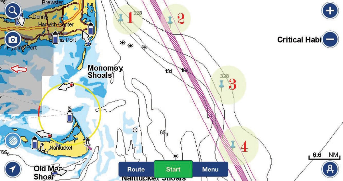
There are four general areas “out east” that tuna hunters use as reference points: Crab Ledge, the BC Buoy, the BB Buoy and the Regal Sword. Crab Ledge and the Sword are actual structure one would loosely define such, while the two buoys are simply reference points within the shipping lanes used more as general markers than bait or fish-holding “spots.”
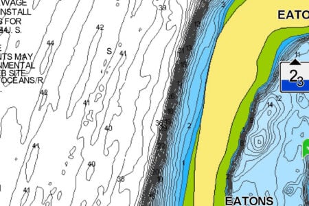
Crab Ledge is closest to the Cape and begins some 6 or so miles offshore, making it more of a near-offshore spot. It is a large area encompassing a lot of bottom making it more of an area than specific spot. This area is easily reached by most small to medium tuna-capable boats, and it can feature large schools of bait which in-turn attract gamefish. This combination means that you’ll seldom find yourself alone here when tuna are known to be present, so be prepared to fish in and around other anglers.
The BC and BB Buoys were used as approach buoys for ships heading to Boston, but they were removed some time ago. Now they are not found on modern electronics or charts, but their general locations are still used as reference points for tuna hunters. As noted earlier, they’re not so much fish-attracting “spots” by any means, but the surrounding waters hold bait and therefore fish at times. The BC Buoy is basically due east of Chatham in the Shipping Lanes, while the BB Buoy is to its southeast and due east of Nantucket.
The Regal Sword is an actual wreck that itself holds bait and fish. Back in 2016 in issue #17 I covered this spot in greater detail, but in short it is the remains of a 575-foot steel freighter that sunk after a collision with the tanker Exxon Chester, a 672-foot long vessel off Cape Cod on June 18, 1979 on a very foggy afternoon. The wreck is located about 25 miles southeast of Chatham in about 275 feet of water over generally sandy bottom.
All of these areas can be fished in a variety of ways including trolling, jigging, run-and-gun and bait fishing, with the fish’s preference and conditions of the day dictating what’s best. Many savvy tuna anglers begin by trolling spreader bars or rigged ballyhoo if the fish are not showing in an effort to find life. There should always be rods rigged for casting if tuna are seen on the surface or if they show deep on the electronics. Expect a mix of sizes in this area from football to giants, and gear should be varied accordingly. This area also still holds very good numbers of cod, pollock and haddock as well as other groundfish, so don’t be afraid to drop a bait or jig to the bottom if the tuna are not cooperating on a given day.