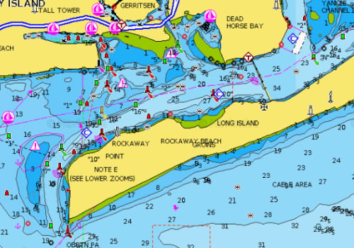
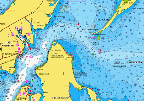
Hot Spots Archive - Page 3 of 17 - The Fisherman

hot spot

BUG LIGHT

For more than 135 years The Long Beach Bar Lighthouse, better known as Bug Light has steered sailors to safety from its location between Orient Harbor and Gardiner’s Bay, welcoming them to the protected waters of Peconic Bay. More importantly, the beacon warns navigators of the hazardous sandbar located along Long Beach Point. The name is derived from the metal framework foundation that created images from the horizon that makes the light look like a large bug, hence the name.

TIN CAN GROUNDS

On January 3, 1944 the Bristle Class destroyer the USS Turner met its fate as a series of explosions shattered the ship approximately 5 miles southeast of Rockaway Inlet. The slang “Tin Can” has been used by the US Navy Fleet for decades when referring to a navy destroyer, hence the nickname of the USS Turner.

17 FATHOM BANK

Nestled on the upper west end of the Mud Hole, 17 Fathoms is always mentioned by the top captains throughout the year. Water depth runs from 94 feet down to a fairly obvious 102 feet (actual 17 fathoms) but the immediate surrounding area can vary in depth 104 to 114 feet, and even drop down to 128 feet just within a half mile or less to the east.

TABLETOP

There are always a few spots that fall by the wayside as the years pass on, and one of them is the Tabletop (39 09.201 N / 74 30.722 W).

LOBSTER CLAW

As bluefin tuna have been summering over in Jersey’s midshore waters the past few years, an oft overlooked spot is in the limelight again – the Lobster Claw.

AXEL CARLSON REEF

Tied with Atlantic City Reef for size at 4 square miles, and one of the two oldest of the artificial bottom layouts, Axel Carlson Reef is second only to the Cape May Reef (4.5 square miles) for size. It is rife with structure, the majority of which is rock, and is a magnet for sea bass, fluke and blackfish.

HARTS COVE, MORICHES BAY

Moriches Bay offers anglers numerous opportunities for a variety of species. You can fish the Elbow area for stripers, triggerfish and fluke. Head over to the mouth of the Forge River for flounder, blues and fluke. Fish the Narrows for big blues, stripers, fluke and flounder. Head west to the “Hole” and catch a few weakfish. There are many other spots too, but one of my favorites is Harts Cove. Since the dredging to the main channel this past year, Harts Cove seems to be even better than in years past.

BREEZY POINT JETTY

Breezy Point is the terminus of the Rockaway Peninsula. It consists predominantly of dune/beach shoreline terrain, with a rock jetty at the tip of the point that extends well outward into the ocean. This famous stretch of boulders is widely known as the Breezy Point Jetty.

THE SOUTH WRECK

Laying on a sandy lair just four miles dead south of Moriches Inlet in 95 feet of water is a mysterious steel schooner known as the Sea Wolf or better known by local divers and fishermen as the South Wreck. With her steel hull facing towards the east, the South Wreck is a large and distinct piece with the bow raising over 10 feet off the bottom while the remainder of the iron clad vessel is resting two to three feet off the bottom. Unfortunately there is a large dragger net that drapes the hull amidships. Fortunately the net isn’t much of an issue for this large piece that affords shelter to many species of fish year round.

SMITHTOWN BAY AND REEF

Tucked between the LIPA Stacks and Cranes Neck in Long Island Sound, Smithtown Bay comes to life once the sand eels settle into the bay and head for the shoals for their annual spring spawn. While this phenomenon usually occurs sometime in May, it may come as early as April or as late as June with water temperatures being a crucial factor. Fluke follow the sand eels and stick around for as long as the sand eels do.

NORMAN J. LEVY PARK FISHING PIER

The pier is located in the unique environs of Hempstead Town’s Norman J. Levy Park and Preserve in Merrick, an environmentally friendly wildlife sanctuary spread over 55 acres on the South Shore’s Merrick Bay.

THE GREENLAWNS

Along the west side of Shelter Island in Peconic Bay is a landmark and fishing hotspot known as the Greenlawns. The name is derived from a pair of mansions side by side of each other with identical size lawns distinguishing the location. While the landscape and scenery may be impressive, it is certainly not the reason why anglers cluster around this area each season. The opportunity for a double digit fluke is the draw for many anglers heading to the North Fork.

SOUTH BEACH, FIRE ISLAND

I’m always amazed that there are still surf fishermen out there who spend little or no time on the backsides of our South Shore barrier beaches.

CROSS BAY BRIDGES

Spanning the eastern complex of Jamaica Bay from Howard Beach in Brooklyn to Rockaway Beach, the North and South Channel Cross Bay Bridges set the stage for some fine all-around action on a variety of species through the course of the season.

HEROD POINT SHOAL

Located on the north shore of Long Island, between Shoreham to the west and Baiting Hollow to the east, the Herod Point Shoal is approximately a 4.5-mile stretch of fishing paradise that produces throughout the season.

FIRE ISLAND INLET’S WEST BAR

Heading west through Fire Island Inlet and just before you approach the deep blue, you’ll pass the backside jetty of Democrat Point on the left, while on the right you’ll pass the nostalgic but severely damaged gateway of what used to be the rock studded peninsula of the Sore Thumb that at one time stood out boldly from the Oak Beach shore of the inlet. Once you pass these landmarks and continue west, you’ll encounter the expanse of the West Bar.