

SUDBURY RESERVOIR, MA
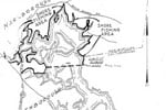
Located 25 miles due west of Boston, the reservoir encompasses sections of Marlborough, Southborough and Framingham in what was originally constructed in the late 1800s to provide an additional water supply for the region. Today it serves only as an emergency backup to the state’s main supply. The section I’m highlighting today stretches along the eastern shore from Marlborough into Southborough just north of the Rt. 30 dam.
The first point that needs to be noted is that this is shoreline-only waterbody. While this can be a deterrent for some anglers, others know that this can result in decreased fishing pressure and bigger fish as a result. I’ll admit that as a kid growing up nearby we did our fair share of swimming and home-made Huck Finn rafting here, but I would advise against such activities these days. However, the proximity did result in getting to know our home waters very intimately and it didn’t take long to discover the hotspots and tactics required to fool the big largemouth and smallmouth bass that lurk below the steel-gray surface. And yes, you read correctly, smallmouth bass; and some real pigs to!
There are only a few marked access points, primarily via DCR Gates along the watershed grounds, and parking can be limited with dirt lots available here and there. Primary access is available along Parmenter Street in Marlborough, but I would also recommend taking a look at a map of the region for additional access. Exploring the watershed is easy thanks to the shoreline being framed by well-worn fire trails. Although in most parts it is heavily wooded from the trail to the shore, it does open up here and there. But where to stop for a cast? Sure, you could pull over, hop out of the car and start casting within a few yards of the road. But, if you’re looking for more of an adventure to seek out big black and bronze fish, well that requires going a little further on down the path.
If you are entering the woods from the access points in Marlborough, you’ll want to work the shoreline south and put in the legwork to find the right structure. The hike is relatively easy along the trail, and you can easily put a mile behind you before you know it, but try to spot changes along the shore, spying through the trees where thinned out. Keep an eye behind you as well, following the contour of the land, as it meets the water. Is it sloping towards the water’s edge? Is it gradual or steep? This will point you to the deeper water which I tend to seek out. There are spots, if you look hard enough, perhaps a mile or more along the main paths/fire trails, that look like deer trails heading to the shore, and they may indeed be from deer, but to the shore they go. And so should you.
There is specific structure that you should pay close attention to when coming upon it. Deadfalls, with the trunk extending out into reservoir, should be worked over thoroughly. We have come across big pines stretching broken limbs into the water where a rubber worm or a jig worked magic. These areas call for heavy line so come prepared. Generally, start working the edges from the shoreline out, and if the structure allows, climb on top of the tree and vertical jig. Another form of structure I’ll seek out is rocks and boulders. One particular spot features a cove anchored by a large boulder in the center where a well-placed stickbait, patiently twitched, has resulted in jumbo bronzebacks on more than one occasion for me. Deeper water, bordered by shallower flats and featuring a pebble-strewn bottom is another great location, particularly in Mid-April to early May when smallmouth move in to spawn. Try a slow-rattling bait like the Rattlin’ Rap in crawdad or a 1/4-ounce spinnerbait and revisit the deeper edge in the fall.