

THE MONSTER LEDGE, NJ
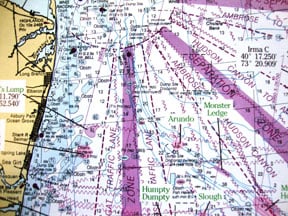
This sheer feature lies about nine miles to the southeast of the Mud Hole proper at: N40 06.092 W73 33.030 in about 150 feet. The Ledge lies about 22 miles from Shark River inlet, 30 from Manasquan and 32 miles from the tip of Sandy Hook and makes up the deep part of the famous Mud Hole. Others list the GPS coordinates as N40 07.900 W73 34.500. The water varies from green to blue-grey, but lacks that cobalt color of the canyons.
Many smaller boats headed for the Glory Hole and the even more distant Chicken Canyon often pull up short and settle for the Monster Ledge depending on conditions. It is a natural part of the continental formation and river channel leading onto Raritan Bay and many shipwrecks dot the area, which can be viewed in contrast to the coast on Capt. Segull chart No. OFGPS18.
Huge bluefish abound in this scaly sector, attracting apex opportunities to feed for tuna and sharks. Tuna used to be the main attraction and bluefin are still caught at the Ledge, but sharks rule the narrow precipice now. Most of the sharks caught there are mako, brown or blue. The temps are best when they stay between 69 and 62. Smaller boaters can make the day trip when the weather is stable and experience some offshore fishing at the fraction of blue water costs.
Drifting the east side of the lobster pot line into 240 feet, you can get a good slick going and still pitch baits under the buoys for shots at mahi, which often can save the day.
You won’t be alone out there as it is a popular but productive spot and tankers use the area since it is an outbound shipping lane coming from Ambrose Channel in the Raritan Bay. Draggers also frequent the area and can ignite a bite when shoveling off discards. Just don’t get dangerously close when they are working. The Monster Ledge is a historic hot spot where many a mako has menaced those looking to tangle with those teeth and snapping jaws.