
WESTPORT RIVER, MA
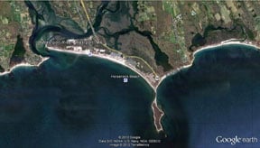
About mid-way south between Fall River and New Bedford, the Westport River is a moderate sized bay with good flow that draws marine gamefish up from the sound all season. Only ten miles east of the Sakonnet River, the Westport is comprised of two branches – West Branch and East Branch – which combine at Westport Point then flow seaward at the west end of Horseneck Beach. This large estuary is a cinch to draw and holds stripers and blues.
Horseneck Beach is replete with bars and holes, structure caused by the flow of the river. Surfmen can walk up the beach to the river outflow at Cherry Point where combined currents of the two branches at full tide really build. The last 3/4 mile of Horseneck is private, and access issues come up from time to time, so it may be necessary to stay on the state reservation. Still, structure here, even on state land, is a beach reader’s dream. On the other side of the river inlet, shore fishers commonly work the Acoaxet Rocks (more favorable in the off season) from locally enforced parking restrictions. Again, flow here is very strong and it draws gamefish up from the sound. Mid river flow slows at low tide and this seems to be the best time for both boat and shore fishermen to cash in on river fish.
Fishing is good in both branches, but I believe the east branch has a slight edge because it serves a larger bay for a greater distance inland with more fresh water flowing in. This side also has hundreds of acres of eel grass which support marine forage. The river is a garden of alewife, shrimp, sticklebacks, eel production, and various forage species. Flow speeds at the narrows are created by the many islands in both branches.
Shores are grassy sod banks quiet enough to hear whatever is swilling in the shallows during night tides. If you can get there by boat, tide depending, some flats-wading is great for fly and light tackle efforts. I’m sure that big stripers use this river season-long but spring arrivals, no doubt chasing alewives (herring), always host the first monsters. The protected estuarine environment here is great yak water that permits access to the upriver hot spots for the four miles inland clear to Hix Bridge.
There is a paved boat launch on your right after you go over the Route 88 bridge over the river. Some of the best water is close by on your right when you head upriver. From here, it is possible to launch small craft for upriver use or for boats that can handle the bigger water downstream. Be warned that the water you’ll find where the river dumps into open water can be challenging and current laden, calling for a higher level of vessel and seamanship. The key to getting to the Westport River is to leave Interstate 195 at Exit 10 for Route 88 south, about 11 miles to the river