A detailed look at the Bone Wreck of Barnegat and surrounding structures.
My introduction to wrecks off Barnegat Inlet came during a family vacation there in the late 1980s while on Coast Guard duty in New York Harbor. A 1984 book by David Seibold and Charles Adams III, Shipwrecks Near Barnegat Inlet, caught my eye at a local shop. After all, a sailor is always gullible for good shipwreck stories!
The book talked about what locals referred to as the “Bone Wreck” just offshore on the north side of the inlet. We were on the south side and I didn’t have a boat back then. So, we contented ourselves sun bathing and swimming. Then, a school of bluefish chased a school of bunker up against the beach below the south jetty. My son and I grabbed a spinning rig and chased the feeding melee tossing in a feather jig as it moved down the beach, pulling in a few snappers along the way. A good day at the shore!
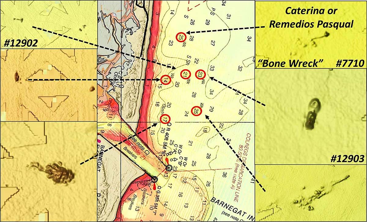
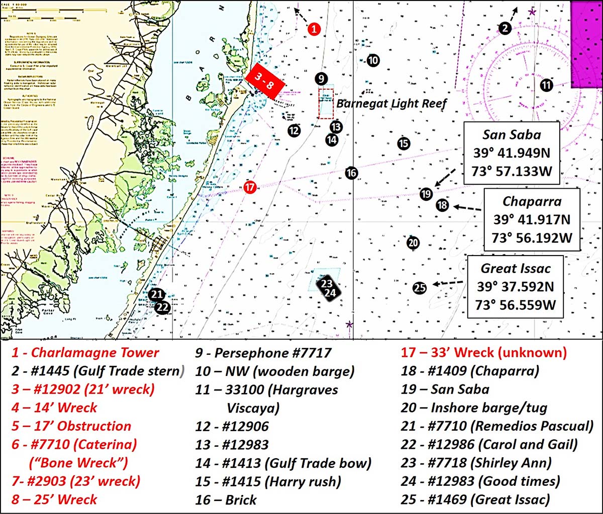
Five charted wrecks and one obstruction are north of Barnegat Inlet just offshore. All six are shown by the Coast Survey’s Automated Wreck and Obstruction Information System (AWOIS) interactive wreck map. Three are documented by specific AWOIS records; clicking on screen icons in the interactive map calls up a box with structure-specific information. Objects shown in the Chart Viewer without AWOIS numbers are Electronic Navigation Chart (ENC) features. AWOIS records often include substantial historical information. However, ENC wreck boxes lack the background information and contain barebones basic information.
The Bone Wreck is certainly easier to say than Remedios Pasqual, although the latter name is certainly more colorful. It is AWOIS Record #7710 which documents a 216- by 40-foot, three-masted sailing ship that went down in 1903. According to njscuba.net, this wooden ship was carrying a cargo of cattle bone for delivery to a fertilizer plant, hence the moniker Bone Wreck. The website puts the wreck 200 yards off of the beach just north of Barnegat Inlet. It also reports that what’s left is low profile wooden debris.
Not So Fast!
Siebold and Adams say the wreck north of the north jetty is that of the three-masted, iron-hulled bark Caterina with a cargo of bone that went down in 1912. They put the Remedios Pascual just offshore at Ship Bottom. So does Aquaexplorers.com, another great diver website with lots of wreck information and graphics, which also notes that it is known to some as the “Surf City Wreck”. AWOIS puts the Pascual farther offshore in vicinity of the Barnegat Light Reef.
New Jersey Maritime Museum puts Caterina 1.75 miles northeast of the Barnegat Life Saving Station. So, there are two “bone wrecks” with both referred to by the same local name! Evidence suggests the correct interpretation is that Caterina is north of the jetty and the Remedios Pascual may be off Ship Bottom, which is how they are shown on Chart 1. Regardless, both wreck sites are several hundred yards off the beach and worth a look when fishing inshore. Additional structures shown in red on the Chart 1 are discussed in the following narrative.

“BAG” Color Shaded Relief images of multibeam sonar data are shown for the six nearshore structures by Chart 2. The images are screenshots taken from the National Oceanographic and Atmospheric Administration (NOAA) Bathymetric Data Viewer (BDV). The northernmost bone wreck is shown in the top right corner of Chart 2. Three of the wrecks have AWOIS numbers as noted. The obstruction shown by the lower left image gives the appearance of a rock pile. If the surface and wind conditions are cooperating, some good fishing structure is just around the corner!
Additional imagery for the five near-shore wrecks is included in National Ocean Survey (NOS) Descriptive Report (DR) H12596 (2013). CARIS 3D imaging for multibeam sonar data and side-scan sonar images for the wrecks are shown by Chart 3. The images provide additional insight about what is there. There’s not much left of the “Bone Wreck” or the other two wrecks closest to shore, shown in Charts 2 and 3, only some leftover bones to pick.
The two wrecks farthest off the beach are somewhat larger. The 25-foot wreck is widely distributed and suitable for drift fishing. The 23-foot wreck to its north is an intact tugboat. On first glance for those who access the DR through the BDV, the CARIS 3D image might look like it is showing a sunken sportfishing boat with a flying bridge. However, it’s the tug bow down in the sand. The image shows the stern on the left and the deckhouse on the right.
Community Findings
Six nautical miles north of the inlet are the remains of the Charlemagne Tower. It is known locally as the “Cedar Creek Wreck” after Cedar Creek on the mainland side of Barnegat Bay. This 29-foot wreck was a 255- by 40-foot, wooden hull, Great Lakes ore carrier. The vessel was running towards shore to beach herself due to failing engines in heavy seas. It didn’t make it, foundering and sinking just offshore. A BDV “DEM” Color Shaded Relief image shows a mound in the center of the wreck circle. These data and the charted wreck circle are supported by a hydrographic survey that was documented by NOS Descriptive Report H11495 (2005-2006) However, the survey predated Superstorm Sandy which struck in 2012.
In 2015, a Navionics Community Layer user marked a spot for this wreck 400 yards inshore on a bearing of 281 degrees true from the center of the charted wreck circle. The wreck may well have been displaced by physical energy generated by Sandy. Prior to the storm, njscuba.net described the wreck as a low debris field with a boiler. The debris may be more widely distributed than before on a line towards the Navionics Community Layer mark.
There are several wrecks with AWOIS numbers just south of the south jetty. However, nothing shows on “BAG” Color Shaded Relief images, so they weren’t included on Chart 1. There is an unidentified wreck off Harvey Cedars that was imaged for NOS Descriptive Report H11495 (2005). The wreck displays as upright and intact with a profile resembles a traditional tugboat with a long deckhouse as seen in Chart 4.
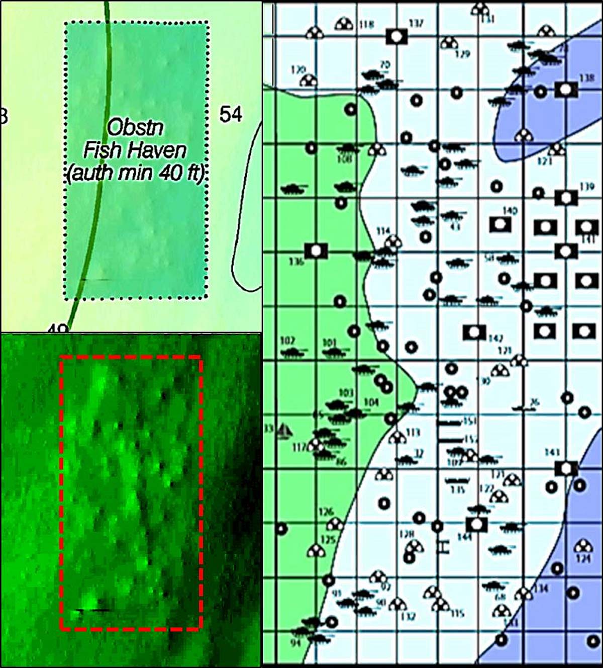
East of the inlet is Barnegat Light Reef, a well-developed artificial reef site with a broad array of patch reefs. Sponsored reef deposits consist of reef balls, tanks, concrete castings, a 40-foot crew boat, a 41-foot sailboat, and several 40-foot deck barges. The only imagery found online is BDV “DEM” Color Shaded Relief. The “DEM” image of sounding data shows dimples on the bottom. These are the patch reef structures which can be correlated with the State color grid. Chart 5 combines these various these images.
Just to the north of the artificial reef is the wreck of the 468- by 63-foot tanker Persephone, AWOIS #7717. She was torpedoed and sunk by a U-Boat in 1942. The ship broke in two. The bow was salvaged and later used to repair another ship which was subsequently also sunk by a U-Boat. What remains off Barnegat is the demolished rear section of the tanker. After being struck by passing vessels, the wreck was blown up by the Coast Guard and wire dragged. What’s left is twisted hull plating spread out on the bottom. The full story is presented in Gary Gentile’s Popular Dive Guide Series, New Jersey Shipwrecks – Central (2001). A picture of the tanker before and while sinking is posted on njscuba.net.
Scattered About
Another wreck of interest is the Gulf Trade (also referred to as Gulftrade and Gulf Trader), a tanker sunk by a U-Boat in 1942. It broke in half. The bow sank where the ship was torpedoed southeast of what became the location for Barnegat Light Reef. Although the bow section was demolished as a danger to navigation, there is substantial wreckage distributed on the bottom. The stern section drifted some 10 miles to the northeast before it sank. Divers report a substantial wreck with some sections rising as much as 20 feet among jumbled wreckage distributed on the bottom. Both sections are extensively covered by njscuba.net, including a very nice underwater video of the stern section. See also aquaexplorers.com.
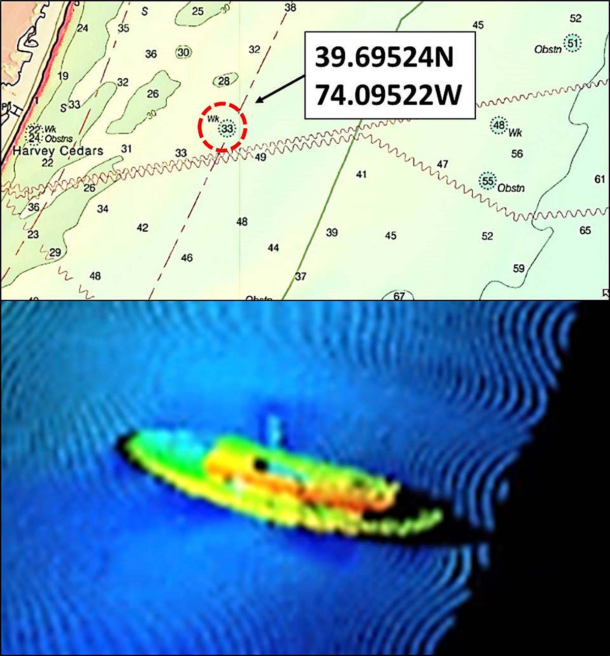
As a closing note, wreck data are incomplete regardless of source. There are inconsistencies between sources with respect to identification of some wrecks and especially with respect to wreck locations. For example, the San Saba and Chaparra were both sunk in the same general location by mines laid by a U-Boat off Barnegat Inlet in 1918. They are listed and shown in multiple locations, as is the USN Great Issac. This Navy tug, which survived service at Normandy but not a collision off Barnegat, is intact and laying on her port side. The Navionics Sonar Chart as annotated in the Community Layer show a substantial anomaly at the coordinates shown on Chart 1. Check both njscuba.net and aquaexplorers.com for additional information.
AWOIS documents a lot of wrecks, yet some well-known ones are not recorded. An example is a wreck site known as the “Inshore Barge and Tugboat” with two structures and a least depth of about 85 feet. According to divers, both are low profile and distributed on the bottom. Divers also report that the wreckage is covered with seabass and tautog. There is an unidentified ENC wreck in the general area where the “Inshore Barge and Tugboat” is shown by a wreck graphic at njscuba.net. So, that’s where it is shown on Chart 1, notwithstanding that a Navionics Community Layer user labeled the wreckage as the Great Issac!
A suggestion – check out both the 60- and 80-foot wreck sites when fishing this area. There are more wrecks out there than shown by Chart 1, but those displayed provide some great structure for hunting fish.
Wayne Young is a former manager of the Maryland artificial reef program for Chesapeake Bay waters. He is the author of “Chesapeake Bay Fishing Reefs: Voyages of Rediscovery” available on Amazon.com. His Facebook page is Chesapeake Bay Fishing Reefs. Look for NOAA’s Bathymetric Data Viewer at https://maps.ngdc.noaa.gov/viewers/bathymetry.