Looking for new tautog spots for the April opener? Consider a side-scan approach.
New Jersey’s artificial reef program is well-organized and superbly documented. In the third and latest edition of A Guide to Fishing and Diving New Jersey Reefs from 2009 (available online at www.nj.gov/dep/fgw/artreefguide09.htm as a downloadable PDF file) you’ll find the general lay of the land along 17 reef sites that encompass more than 25 square miles.
Reef materials are categorized by type and displayed as icons on a color layout drawing with a geographic coordinate grid. Reef positions are provided as GPS coordinates. Commercial electronic bathymetric chart products showing depth contours, shaded bottom relief, and user-added field data including icons at sponsored reefs within the fish havens are available.
Most, if not all, of the privately or commercially sponsored reefs in the fish havens have been entered into the Navionics Community Layer, which can be accessed online. Also, recreational diving websites – notably www.njscuba.net and www.njwreckdivers.com – post extensive details about natural and artificial reefs and wrecks that are especially helpful for scouting reefs and wrecks and interpreting what is displayed on boat electronics.
What more could fishermen want? Side-scan sonar images perhaps?
This wish is already granted for three of the northern coast fish havens. The Sandy Hook, Sea Girt, and Axel Carlson Reefs are within complete multi-beam side-scan sonar coverage images available using the National Oceanic and Atmospheric Administration’s (NOAA) Bathymetric Data Viewer (BDV). The Cape May Reef has partial BDV side-scan sonar coverage as well. Two additional charted circular fish havens near the Cape May Reef, although not part of the New Jersey program, are within full BDV coverage, albeit with minimum structure.
A browser search for “NOAA Bathymetric Data Viewer” will lead you to the NOAA BDV website at maps.ngdc.noaa.gov/viewers/bathymetry. In Discovering Atlantus (The Fisherman, March 2020 edition), we described how to use the viewer. The BDV side-scan sonar images reveal additional detail and can be used to visualize the fishing reef and surrounding structure. Sea Girt Reef offers a good case study. Although a lot has been written about this fish haven, the BDV provides an alternative look with detail that aids in selecting where to prospect.
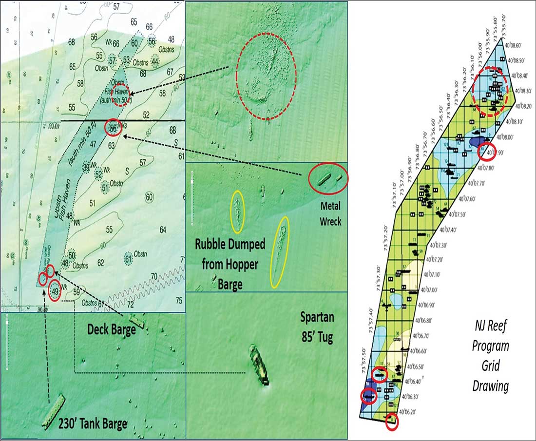
Image Research
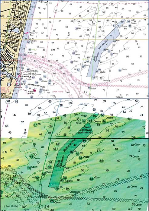
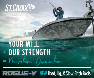
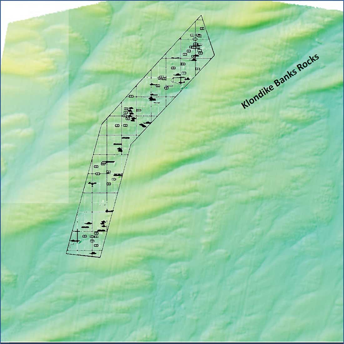
In Illustration 1, you’ll see a standard nautical chart of the reef and a translucent nautical chart on top of a color-enhanced BDV side-scan sonar image. The color-shaded area in the bottom image shows the upper extent of BDV side-scan sonar coverage at this location. Color-shaded sounding data can also be placed under the chart to fill in areas not covered by the side-scan image, thereby providing a three-dimensional perspective of bottom contours.
The reef site straddles the Klondike, a famous bottom formation. The bottom image reveals that the upper portion of the site approximately conforms with a natural trough between elongated mounds. Closer zooms show that most of the reef materials here are on a side slope or in the trough itself.
At minimal zoom, the BDV image provides a broad-area view of bottom conditions and structure location. Zoom in on the side-scan sonar image to increase the definition of individual objects, as shown in Illustration 2, which also includes the reef program layout as a reference. Coordinates can be taken from the grid drawing and punched into electronic charts as waypoints.
At the southeast corner is a wreck. A deployment picture for the tug Spartan on www.njscuba.net shows a tug superstructure that is consistent with the side-scan image. Another wreck is along the northeastern edge just inside the fish haven boundary. According to the NOAA Coast Survey’s Automated Wreck and Obstruction Information System (AWOIS), it’s an old metal wreck with two decks that rises 20 feet off the bottom. NOAA divers found it heavily encrusted with corals and other sea life.
Dredge Rock
The northern New Jersey reefs have also benefitted greatly from the availability of dredged rock from shipping channels, demolition rubble, and split-hull hopper barges used for ocean dumping of dredged material. Sea Girt is no exception. Still referring to Illustration 2, a circle with a depression in the middle and elongated teardrop shape are signatures of hopper barge placements.
Several teardrop-shaped deposits of concrete rubble are inside the yellow circles on the graphic. Inside the dashed red circle at the north end of the reef, there appear to be several teardrop-shaped deposits although the grid drawing shows widely broadcast concrete castings across the bottom. There is also a tear-drop shape just south of the circle. Their composition is uncertain, but rock or rubble would be consistent with reef development practices.
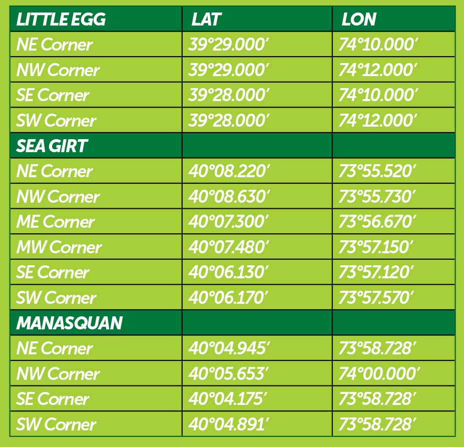
The New Jersey Division of Fish and Wildlife (Division) is currently conducting artificial reef pot surveys at the Little Egg, Sea Girt, and Manasquan Inlet reef sites through April (and possibly into May). High flyers will be deployed throughout the reef sites. The Division has asked that anglers avoid them as best as possible. The affected reef locations are as follows:
At maximum zoom, as shown in Illustration 3, reef objects appear similar to how they would be displayed on a small boat side-scan sonar. The object displayed is a former 230-foot long Morania tank barge. It’s the wreck located at the southwest corner of the reef site.
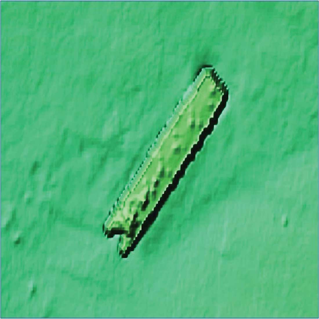
Natural rock is present on the Klondike Banks, especially the deeper eastern end. Illustration 4 shows a portion of this rocky ground. Note the improved clarity for the BDV zoom on the rocks shown in the box insert. Be sure to check out a detailed description and underwater photos of these rock deposits posted on www.njscuba.net.
The final image, Illustration 5, stiches a simplified version the reef program drawing into the BDV side-scan sonar image. The combined image can be used to interpret the position of individual reefs in relation to bottom bathymetry.
Sea Girt Reef has lots of structure, is not far offshore, and sits right in the middle of one of the great hotspots along the northern coast. When prospecting for sportfish or checking out boat sonars, it’s diversity of reef types spread out across the site offers a great place to start.
Wayne Young is a former manager of the Maryland artificial reef program for Chesapeake Bay waters. He is the author of “Chesapeake Bay Fishing Reefs: Voyages of Rediscovery” available on Amazon.com. His Facebook page is Chesapeake Bay Fishing Reefs.