Using technology to help open the door for the doormat hunters.
At 14.8 nautical miles offshore, Shark River Reef is a long run back to shelter when the weather sours. But as one of the deepest sites in the New Jersey State Reef Program, this sea bottom oasis in an otherwise flat and barren offers great midrange access to anglers out of Manasquan and Shark River inlets.
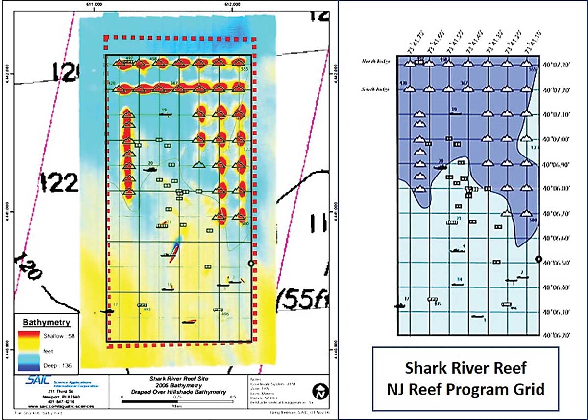
Side-scan sonar-like coverage by the National Oceanic and Atmospheric Administration’s Bathymetric Data Viewer (BDV) is not available for this fish haven. The BDV’s color shade relief of sounding data covers the site, but is unrevealing except for a single large hump east of the site, discussed later. Fortunately, as shown by the color-shaded bathymetry overlaid on the fish haven in Chart 1, other bathymetric images are available.
A detailed bathymetric study of the old Mud Dump Site and surrounds (since 1997 identified as the Historic Area Remediation Site, or HARS), was contracted by the New York District, U.S. Army Corps of Engineers (USACE). Completed in 2006, the work was performed by Scientific Applications International Corporation (SAIC). HARS holds a variety of now-capped contaminated materials disposed there by open water dumping before the Clean Water Act and other environmental rules and regulations closed it down.
A New Look
Modern technology was used to develop a composite characterization of HARS bottom features. Substitute sites were needed for environmentally suitable dredged rocks from harbor dredging projects. So, the study also included three state reefs including Shark River Reef, prospective alternatives for marine placement.

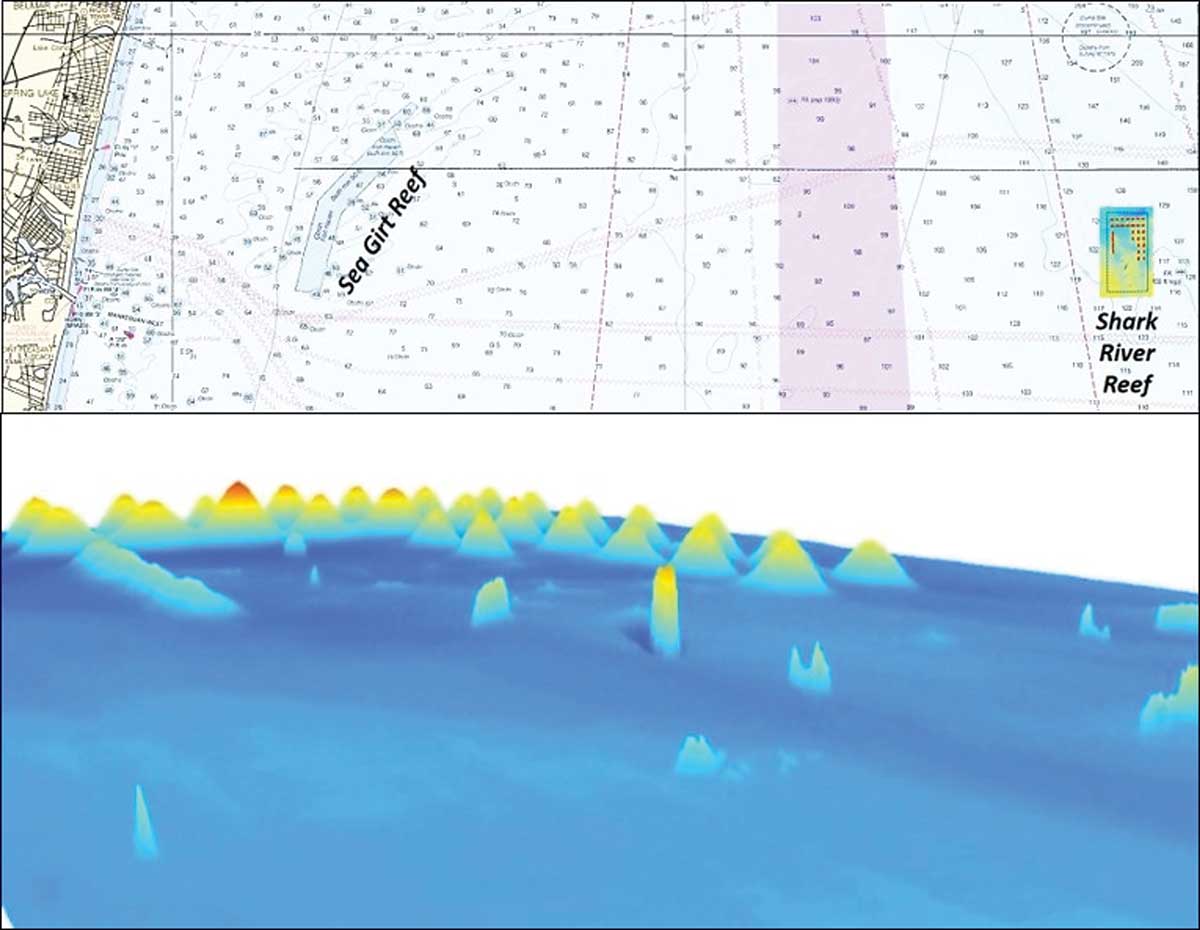
Shark River Reef is today distinguished by well-ordered deposits of dredged rock from harbor channel deepening and maintenance projects. As depicted in the bottom image of Chart 1, there are a large number of huge “patch” reefs with high vertical relief enhanced by a smattering of sunken vessels adorn the site.
As shown in Chart 2, rock piles dominate the northern half of the fish haven; wrecks are mostly in the southern half. These structures provide cover for baitfish and predator foraging grounds. Reef types, configurations, and overall layout also offer trolling lanes as well as bottom and wreck fishing options.
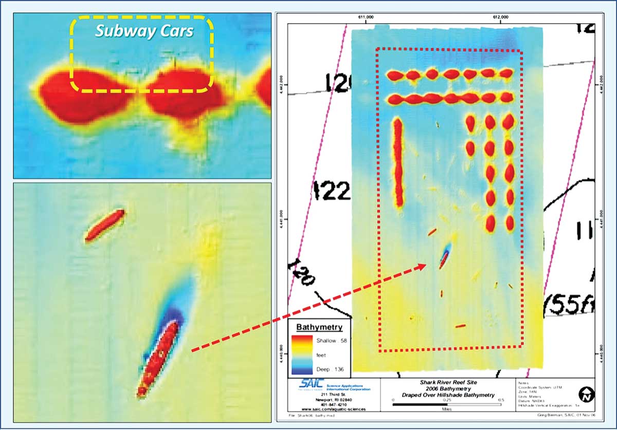
SAIC produced the multibeam sounding images embedded in Charts 1 to 4 (used here courtesy of the New York District, USACE, and SAIC). Data were run through a computer model to produce a side-scan-like sonar image of reef configurations without side-scan shadows.
Bottom conditions may have changed following Super Storm Sandy in 2012, notwithstanding the deep water and that most reef deposits are substantial and heavy. Sedimentation or scouring may have occurred, and, as discussed later, some lightweight reefs have shifted position. There are other studies with bathymetric images, but images from this study are particularly helpful for scouting the reef site layout.
According to A Guide to Fishing and Diving New Jersey Reefs (3rd edition) and historic information posted at NJScuba.net, rocks from harbor dredging projects provide the majority of structure within this fish haven (and several of the inshore fish havens as well). Almost four million cubic yards of rock were deposited with huge rock mounds aligned into two east-west and two north-south ridge lines.
The images also show a partial third north-south ridge in the northeast corner to which at least one additional rock pile has since been added. Without interconnecting minor ridgelines, they have the character of small peaks and are named as such (e.g. “Dive Council Mountain”). The piles rise as much as 70 feet above the bottom. Their round shape indicates deployment was from a stationary dump scow or bucket crane (a teardrop signature signifies that a deposit was made from a slowly moving hopper scow); dump scows being one of the primary deployment methods.
On the west side of the fish haven, there is an unbroken ridge oriented north-south. The ridge top, rising about +/- 60 feet above the bottom, forms a narrow, rugged plateau.
Wreck Deployments
Donated obsolete vessels are scattered across the site, a few of which I remember from my Coast Guard service in the Port of New York and New Jersey. The largest, the USS Algol, is a 459-foot former transport. The wreck rises +/- 75 feet above the bottom. Just to the north is a three-deck, 261-foot long barracks barge. Small self-propelled tank vessels comprise the majority of the remaining reefs, along with several tugboats.
During 2003, 50 “Redbird” subway cars were pushed overboard and landed on the steep side slopes of the north side of the northwestern most rock mounds. New Jersey’s Atlantic Coast is well-covered by diving guide books and websites. From extensive diver information posted on Rich Galiano’s NJScuba.net, we know that at least some Redbirds have shifted position, sliding or tumbling down the steep slopes.
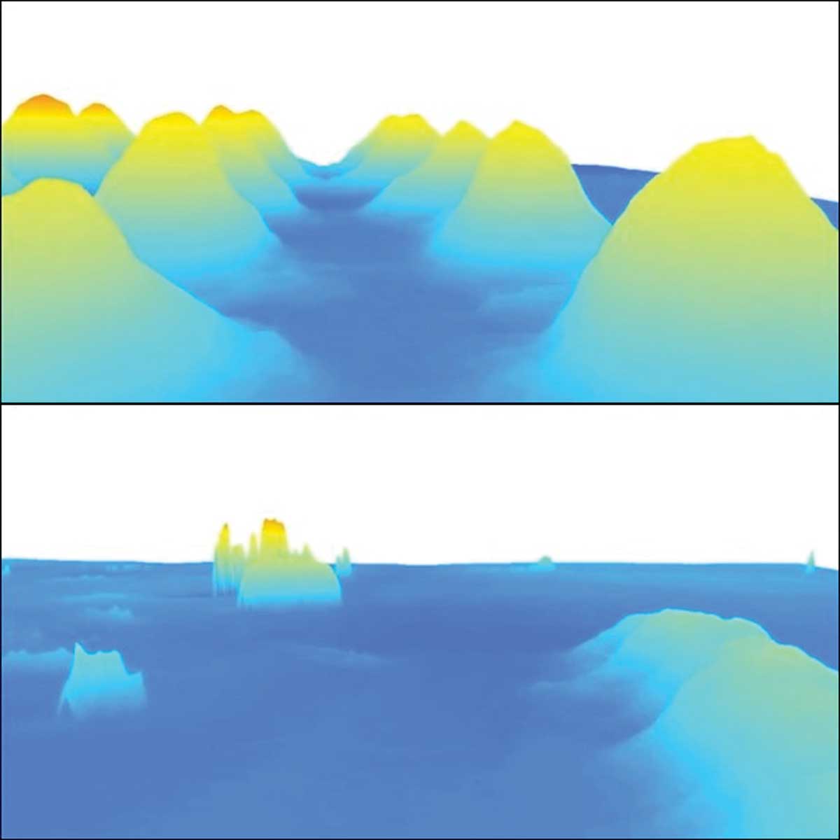
By 2016, recreational divers found the subway cars in highly deteriorated condition. I’ve viewed videos showing tops missing, and thin sidewalls partially collapsed, leaving rusted razor-edge sheets standing to snip fishing lines. This diver website is one of the best to consult for locations and details about wrecks and dive sites. Click a reef icon on one of its location charts, and then click on a wreck icon to call up extensive information including descriptions, surface and underwater pictures and videos, and reef and vessel operational histories. Also posted on the website is a bathymetric simulation of Shark River Reef produced by SAIC for the aforementioned study.
Stills from the bathymetric simulation convey the peak-like character of individual rock deposits at Shark River Reef. Also shown is the north-south ridgeline on the west side. The north-south and east-west orientations provide trolling lanes. Take a troll through when prospecting and watch side-scan sonar and fishfinder screens for sweet spots holding fish.
The intersection of the west side ridge with the western end of the east-west ridges in the northwest corner is well-positioned to be affected by ebb currents from the harbor. The northeast intersection of the east-west and east side north-south ridges is another place to check.
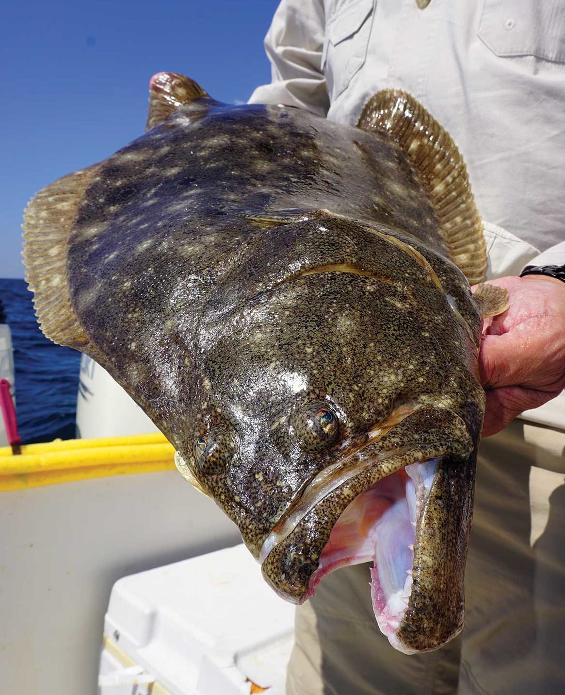
Also check the wrecks for tautog, croakers, sea bass, and cunners. You may also find a few jumbo fluke lurking along the reef edges, especially a little later in the summer.
So, how well do reef program grid icons correlate with actual reef positions? Rather well, actually. By taking a look at Chart 3 you can see on the overlays a stripped-down line drawing version of the grid on the SAIC bathymetric image. Grid symbols correlate very closely with shown positions. The grid shows one more rock mound than the bathymetric image. Most likely it was deposited after the multibeam sounding data were taken.
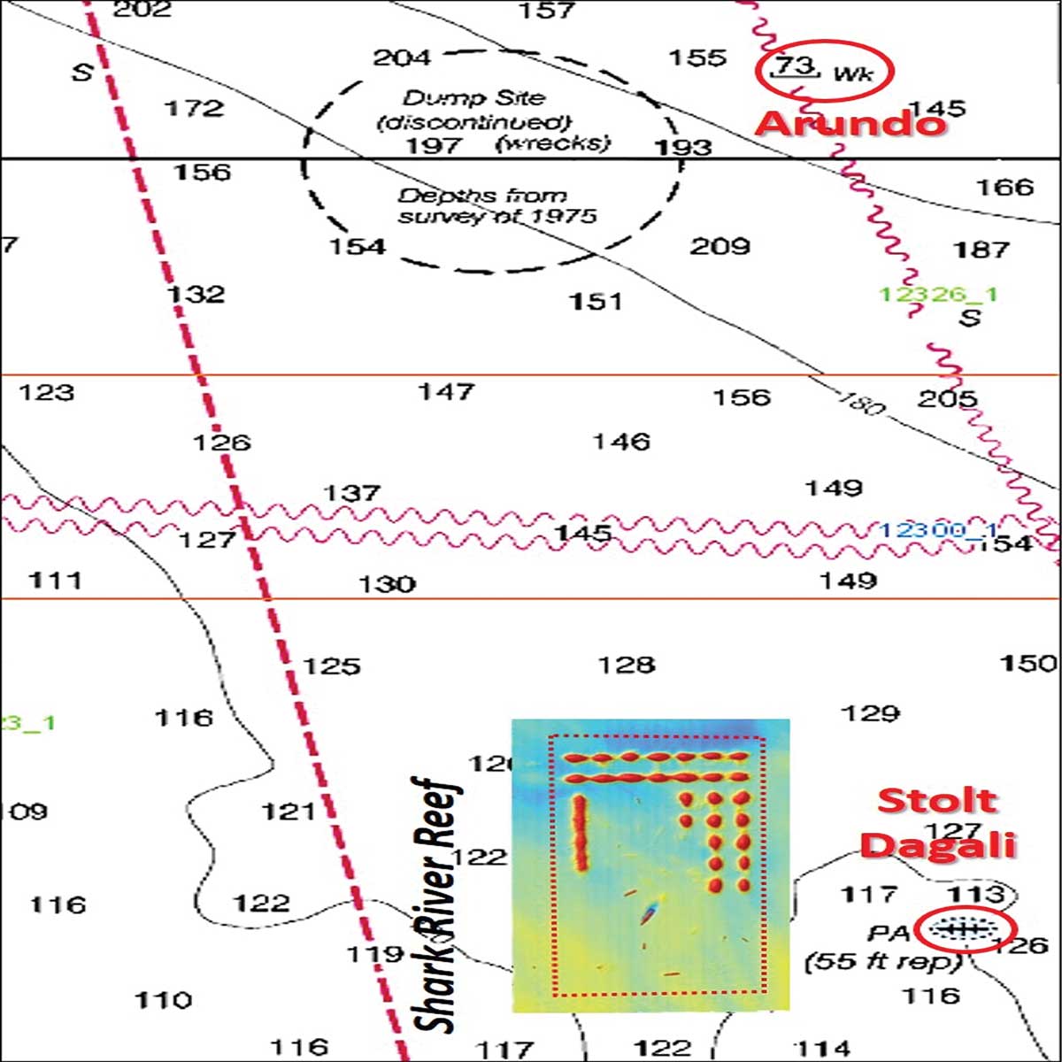
About a half-mile east of the reef in Chart 4 you’ll find the 582-foot long Stolt Dagali, one of the most popular dive sites in the region. Cut in half by a collision with a passenger liner in fog on Thanksgiving 1964, this tanker sank in 122 feet of water. BDV “DEM” color shaded relief of sounding data show a large mound at the charted location. While the wreckage is covered with multiple fish species, be prepared to lose some tackle; imagery shows the rig-grabbing potential anglers have experienced first-hand over the years. To the northeast about 3-1/2 miles are the wreck of one or more vessels including the 412-foot Arundo. Torpedoed in 1942 by U-136, this freighter immediately sank at about the charted location.
Offshore fish havens and wrecks are reefs that I find are simply too far for me and my 20-foot outboard walkaround. If I haul up from to New Jersey for a family visit, I’ll be content with the inshore reefs that are on my old croaker’s checkout list. Yet, if looking for an offshore fishing adventure, Shark River Reef and nearby wrecks offer substantial fishing opportunities.
Wayne Young is a former manager of the Maryland artificial reef program for Chesapeake Bay waters. He is the author of “Chesapeake Bay Fishing Reefs: Voyages of Rediscovery” available on Amazon.com. His Facebook page is Chesapeake Bay Fishing Reefs. Bathymetric images appear courtesy of the New York District, U.S. Army Corps of Engineers, and Science Applications International Corporation (SAIC)