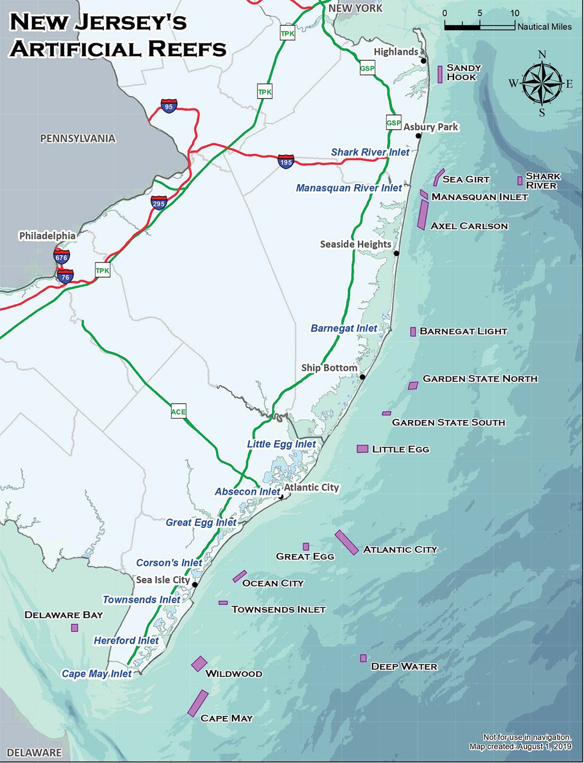
It’s no secret that December brings the prime month for Jersey bottomfishing as blackfish, sea bass, cod, pollock, ling and porgies all colonize shipwreck and manmade reef structures from tip to tip of the state. Even better, there are so many submerged structures to set up on you will never run out of options, most notably highlighted by the contributions of the New Jersey Division of Fish and Wildlife’s bountiful artificial reef program.
Since its inception in 1984, New Jersey’s artificial reef program now boasts a total of 17 artificial reef sites which provide ample opportunity to find easy spots to pull on some fish. Some lay within a mile and half off the coast such as the Manasquan Inlet Reef while others extend 23 miles offshore as the Deepwater Reef – though most exist in the 2- to 10-mile range making access easy for the day boater or hardcore charter.
Reefs encompass submarine real estate anywhere between a half-square mile up to 5.4 square miles comprised of a wide array of structures from Army Tanks, concrete tire units, barges, trawlers, rock rubble, subway cars and much more.
Those who’ve been around for a few years may remember the old printed reef book available through the New Jersey Division of Fish & Wildlife; that fully detailed chart book containing all the New Jersey reef sites and the GPS coordinates of every single piece of structure on those reefs can be downloaded from the njfishandwildlife.com website by typing out the following link:
dep.nj.gov/njfw/wp-content/uploads/njfw/2022-NJ-Artificial-Reef-Guide.pdf
| REEF SITE | NW CORNER | SW CORNER |
|---|---|---|
| Sandy Hook | 40° 23.300’ / 73° 56.600’ | 40° 20.880’ / 73° 56.600’ |
| Shark River | 40° 07.330’ / 73° 41.800’ | 40° 06.200’ / 73° 41.800’ |
| Sea Girt | 40° 08.630’ / 73° 55.730’ | 40° 06.170’ / 73° 57.570’ |
| Manasquan Inlet | 40° 05.638’ / 74° 00.032’ | 40° 04.920’ / 73° 59.959’ |
| Axel Carlson | 40° 04.180’ / 73° 59.750’ | 40° 00.350’ / 74° 00.650’ |
| Barnegat Light | 39° 45.870’ / 74° 01.950’ | 39° 44.620’ / 74° 01.950’ |
| Garden State North | 39° 37.980’ / 74° 02.200 | 39° 37.000’ / 74° 02.500’ |
| Garden State South | 39° 33.800’ / 74° 07.200’ | 39° 33.330’ / 74° 07.350’ |
| Little Egg | 39° 29.000’ / 74° 12.000’ | 39° 28.000’ / 74° 12.000’ |
| Atlantic City | 39° 16.220’ / 74° 16.180’ | 39° 13.300’ / 74° 12.700’ |
| Great Egg | 39° 15.000’ / 74° 22.000’ | 39° 14.000’ / 74° 22.000’ |
| Ocean City Reef | 39° 11.100’ / 74° 32.850’ | 39° 09.820’ / 74° 34.970’ |
| Townsend’s Inlet | 39°06.700’ / 74°37.500’ | 39°06.250’ / 74°37.500’ |
| Deepwater | 38° 59.000’ / 74° 11.500’ | 38° 58.000’ / 74° 11.500’ |
| Wildwood | 38° 58.800’ / 74° 40.900’ | 38° 57.550’ / 74° 42.600’ |
| Cape May | 38° 53.970’ / 74° 40.620’ | 38° 50.670’ / 74° 43.250’ |
The newly launched 1.1-square-miled Delaware Bay reef site received its first deployment of dredge rock on January 2, 2018 at 39° 02.85600’ / 75° 04.05100’.