Some valuable insight into the dynamics that cause both subtle and dramatic changes to our Island’s shorelines.
First of all, all beaches change, but some change more drastically and/or faster than others. L.I. Sound beaches change the slowest and the least over time because the beaches are dominated by large boulders, pebbles and coarse sand. In fact, until the great blizzard of January 1977 featuring strong winds with gusts in excess of 70 mph for two days, L.I. Sound beaches changed very little. But, during that storm relentless strong waves moved giant boulders, seawalls were damaged and sand was pulled off the slopes of the beaches. The combination of sustained high east winds, huge waves (for L.I. Sound) and very high moon tides also pushed water so high on the beaches they eroded them in places that waves never touched before. The severe damage from that storm changed the dynamic effects of tides and waves along Long Island Sound beaches and opened the flood gates to frequent changes, because the long-term stability had been altered. Now, due to this instability, even average nor’easters produce changes and erosion. In spite of this and the fact that Sound beaches have been reshaped in many places, they continue to change a lot less and less frequently than south shore inlet and ocean beaches.
Inlets
Inlet beaches can change a lot near the mouth, but little up-inlet where the effects of winds and waves are usually much less significant. However, at the mouth of our inlets, beaches along the sides can change a lot due to storms, excessive high tides, as well as the east to west littoral drift of sand. That’s one reason why our inlets are dredged so often and why there can be a beach next to a rock jetty one week, and it can disappear by the next week.
Another less well-known reason why inlets change so much at the boundary between estuary and ocean is that they are not dredged correctly. Modern oceanography has established that any channel or inlet becomes more stable when dredged in line with their natural flow. On the south shore of Long Island that line runs northeast to southwest. Over millions of years nature developed rather stable flow patterns between the ocean and the bays, so it would seem logical to dredge according to nature’s plan; doesn’t it? However, our inlets are less stable compared to the 1960s and 1970s. The instability is in part a result of the Corps of Army Engineers insistence on dredging some inlets in a north-south direction (Jones Beach) or creating unusual channels in various directions (Fire Island).
Let’s consider the Fire Island Inlet situation. In recent decades, it has experienced rapid shifting of sand with corresponding shoaling at very fast rates. The final blow to this inlet’s stability was struck in the 1980s when the Corps, under pressure from some special interest groups, dredged a southeast channel off the traditional channel. When a very strong storm with near hurricane force southeast winds hit shortly after the channel was dug, huge waves rumbled off the ocean, maintained much of their height and force in the southeast channel, smashed into the Sore Thumb jetty and destroyed parts it. At the same time, an elongated and, from an angling perspective, productive Cedar Bar disappeared, and the mouth of Fire Island shoaled quickly. In addition, the Corps insisted on using a scoop-dredge instead of the traditional method of sucking up the sand and pumping through pipes to replenish nearby beaches. The scoop dredge then dropped the sand 1,000 feet off Gilgo Beach.
Public Hearing
A public hearing was held to allow interested parties to comment on the proposed dredging plan, and many people, including me, testified that based upon recent oceanographic research, erosion, damage, and stability would be upset by the southeast channel dredging. Also, by dumping sand 1,000 feet off the beach at Gilgo erosion would accelerate there because the offshore bar that traditionally dampens waves would be replace by a new one 1,000 feet offshore. The new bar would be too far off the beach to prevent waves from reforming to their original height. In addition, since the sand dumped on the new bar was not compacted by waves and tides, it quickly flattened exposing Gilgo to even more abuse by storms and waves. Erosion at Gilgo began immediately and changed it so much that intermittent closures were common. Eventually, the beach became so narrow that it has been permanently closed the last few years. How did this happen? Sadly, although public testimony was on target, it was ignored. Today, Gilgo is severely eroded and we have on-going rapid shoaling in Fire Island Inlet.
As stated, some other south shore inlets, such as Jones and Moriches, were dredged in a due north-south direction. They have jetties on either side, and some are quite narrow. Anyone who transits in-and-out of the ocean via these inlets by boat knows about the constant shoaling, the dangers when tide and wind are against each other, and the off-inlet sand bars that seemingly form out of nowhere and shift suddenly, causing far too many boats to go a ground. All of our south shore inlets could be stabilized, need far less dredging, could be much safer, and easier to fish if only the inlets would all be dredged in a northeast-southwest direction and wide enough to allow good current flow without the intense turbulence associated with most of them during storms and severe moon tides. Will it ever be done? At this point doubtful but still possible, if all of us who use these inlets demand it.
The Corps of Army Engineers seems unwilling to change from practices that have been used since the mid-20th century. Unfortunately, dredging decisions are based on need, available funding and hydrologic studies. Hydrologic studies are made by engineers who specialize in the characteristics of water and its movements in relation to the surrounding land. They do not use consulting oceanographers who understand how all elements of nature interact with the oceans. Hydrologic studies are very useful in many places such as predicting how subsurface water levels change when water is either removed by humans or added via redirection. They can accurately predict how rates and directions of flow will change as we manipulate our environment. However, our oceans cannot be compared to ground water, rivers, lakes and ponds with respect to the effects of storms, giant waves and strong winds. Therefore, without understanding how oceans really work, many dredging projects are done incorrectly. Now, don’t misunderstand me, the Corps provides a very important service to society by maintaining navigation channels, preventing estuaries from stagnating and replenishing beaches, but it’s time to be a little more flexible about the dredging “plans” not the execution.
Ocean Beaches
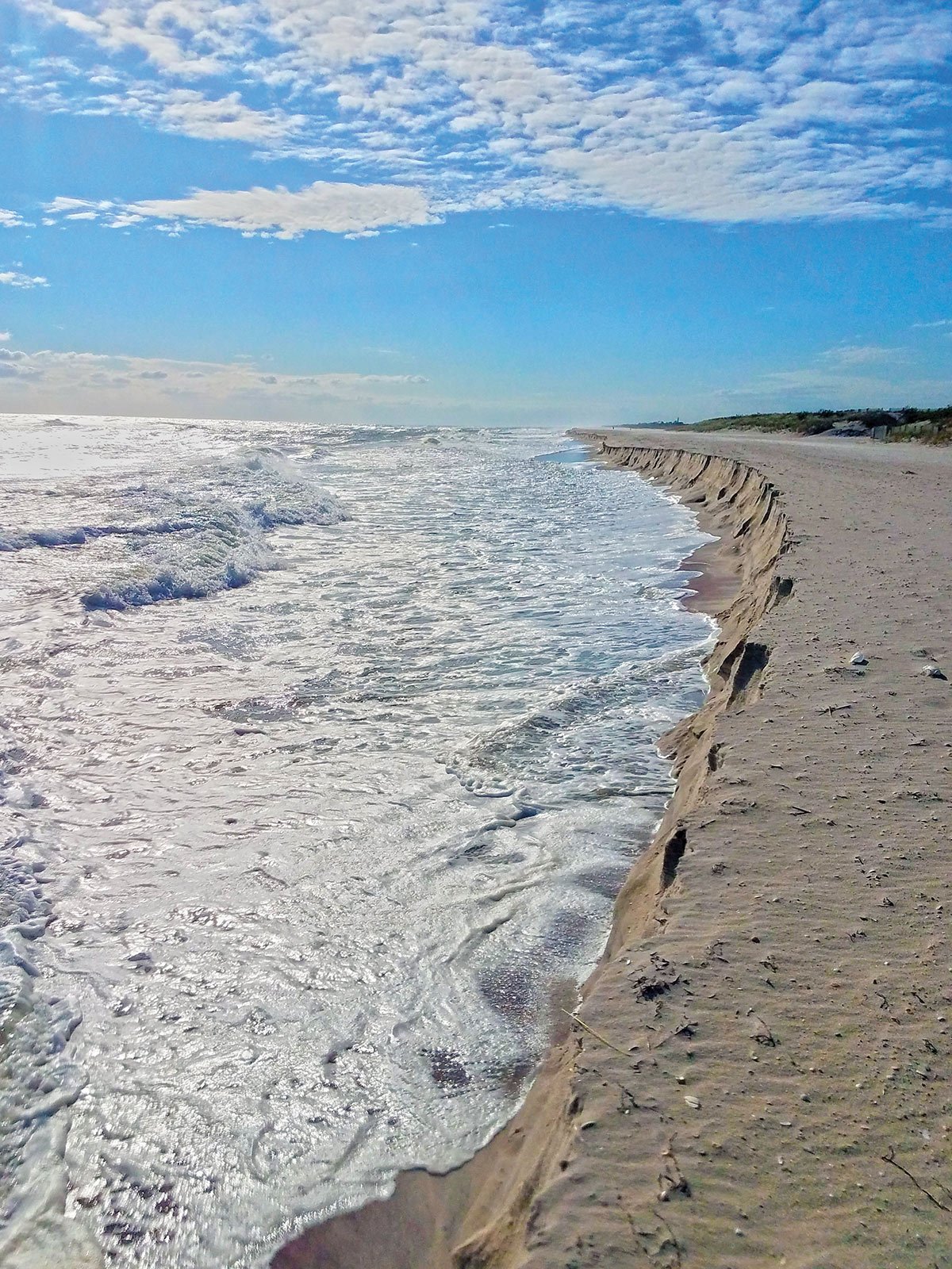
The fastest, most striking, and most severe changes occur along the ocean beaches, since they are composed of sand that is sometimes compact and sometimes loose, and because they are exposed to the ocean. Of course, the ocean comes with a host of powerful features including swells, hurricanes, and nor’easters, big winds without buffering from buildings, trees, hills and mountains. The contentious nature between sand and the elements can be likened to a powerful professional boxer fighting an inexperienced amateur. In this simile, there are repeated body blows that batter and scar the opponent changing both his appearance and demeanor. The barrier beaches along the south shore are the result of an east to west littoral (shoreline) drift of sand that comes from the erosion of the east end and subsequent slide to the west. Over millions of years this sand moves a great distance, so that Sandy Hook in New Jersey is actually made of sand that originated at Montauk.
Littoral drift provided the sand for our barrier beaches, but it still must be shaped by other elements. The constructive forces include a gentle (10-15 mph) prevailing southwest wind that retards the littoral drift and at the same time produces waves that push the sand up onto the beaches. We call these southwest winds sea breezes and should be a consistent part of the summer months that in turn should build the beaches. Of course, there are days without wind, days of breezes from other directions, and swells generated by offshore storms whether or not local winds are blowing. These short-lived summer variations from sea breezes sculpt the sand, push it east, then west, then up onto the berm, then pull it down toward the lip. The above description is for a “normal” summer period. However, as we know, our weather patterns have not always conformed to normal, so in recent decades the beaches don’t look as they should come September.
What should our ocean beaches look like in September? To start, there should be about a 45-degree angle from the berm to the lip. Second, there should be a good trough that is 4 to 5 feet deep at low tide. There should also be points of sand that stretch out into the trough and mini coves between the sand points, and there should be an offshore bar about 75 to 100 yards off the beach slope. In this configuration, the beach is stable and can withstand the punishing body blows from a nor’easter, as long as the nor’easter is fast moving and thus of short duration. If the week or weeks that follow are tranquil, any damage can be repaired. However, in recent decades we experience nor’easter after nor’easter and ones that seem to last days instead of hours.
What does this do to our beaches? First, repetitive coastal storms do not allow the beaches to repair and storms that last days move the sand quickly from east to west. The net result is to flatten the beaches; the situation during the fall 2018. A flat beach affects beach anglers because we cannot fish them as easily as beaches with features described above. Furthermore, without coves and points baitfish simply move freely, and that inhibits the development of blitzes, because predators cannot trap bait against the edges of structure pieces.
Making Things Worse
To make matters worse, coastal storms in recent decades have featured due east winds that accelerate the flattening of the beaches rather than traditional northeast winds that are easier on beaches. Unfortunately, we’re not done yet. Meteorologically, if the tract of a storm produces east winds as it approaches, it will tend to produce strong due west winds after it passes instead of northwest winds.
So, flattened and scarred, our beaches take an additional body blow when the subsequent west wind howls. Obviously, a wind that blows northeast or northwest will be angled over the land and out to sea and therefore produce a lot less damage. In addition, winds that blow from the east not only push sand along the beaches, but eventually into the inlets and that accelerates the shoaling of the channels: a double whammy!