Join The Fisherman Magazine’s Matt Broderick and Mike Caruso as they make an incredible discovery at Westhampton Beach on Long Island, as the MiniPSAT tag originally deployed in a striped bass on June 17 aboard Chuck Many’s Tyman off Romer Shoal in Raritan Bay, NJ is found! This particular tracking device has been at sea for 95 days, connected to a 44-inch striped bass named Hail Mary; we hope to have more about her travels in November, but be sure to pick up the October edition of The Fisherman Magazine for all the details on the Northeast Striped Bass Study, and how that tag made its way to Long Island.
The results are in from a pair of satellite tracked striped bass in the Northeast Striped Bass Study.
In our October edition (4 Out Of 5: A 2021 Striper Tagging Update) we gave a complete status report on the five MiniPSAT devices deployed thus far in the 2021 Northeast Striped Bass Study. Named after our sponsors, each tag was programmed to release from the fish at the four-month mark.
Tag #1 named Navionics
Tagged aboard Fin Chasers on May 24 off Sandy Hook, NJ. Began uploading on June 6 along Staten Island shoreline; tag found and returned to Gray FishTag Research on June 14.
Tag #2 named AFW
Tagged aboard Tyman on May 24 off Sandy Hook. Began uploading on August 23 on land near Westerly, RI (41° 20.880 N / 71° 49.140 W) on the day after Tropical Storm Henri made its official landfall, and at that location. Tag whereabouts unknown.
Tag #3 named Hail Mary
Tagged on June 17 aboard Tyman off Romer Shoal in Raritan Bay. As of September 7 there had been no upload information as yet from this fish.
Tag #4 named Seaguar
Tagged on June 30 aboard Al Steiger’s 31-foot Steiger Craft DV Miami off Montauk, NY. Tag began its upload on July 25 near East Hampton, NY; tag found and returned to Gray FishTag Research.
Tag #5 named PENN
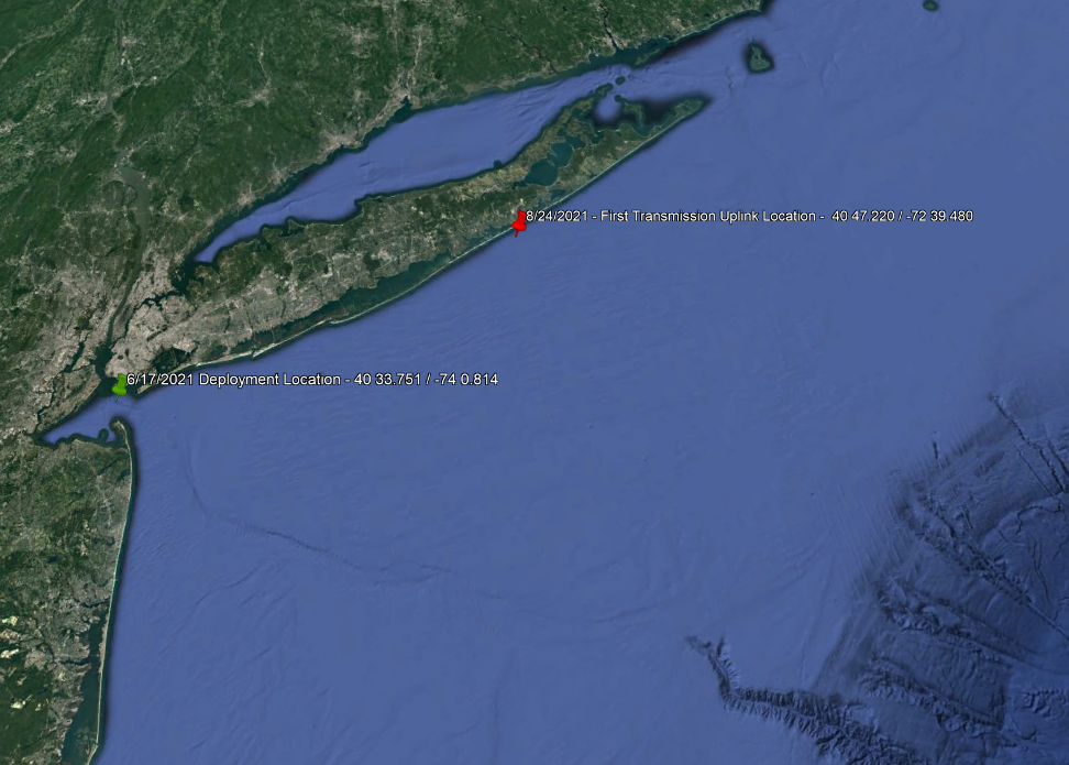
Tagged on June 30 aboard Al Steiger’s 31-foot Steiger off Montauk which began transmitting on August 24 off Fire Island (40° 20.400 N / 73° 10.140 W); last upload connection was made on September 4 off Stone Harbor, NJ (38° 59.880 N / 74° 30.480 W).
Since that October edition article in The Fisherman, we have been able to track more comprehensive movements of three of those five sat-tagged striped bass, Seaguar (25 days), PENN (55 days) and as of September 21, Hail Mary (95 days).
When looking over the three tracking charts included in this month’s Northeast Striped Bass Study update, it’s understandable why some would be skeptical of the migration patterns of these three fish (and those five tagged previously, Liberty and Freedom in 2019, along with Cora, Rona and Independence in 2020), perhaps even wondering aloud about the accuracy of these tags.
Well, to borrow a line from our July edition update (’21 SAT Tags Deployed: Gray Fishtag Research Returns) let’s just call this another one of those, “here, hold my drink” moments.
Finding Our Own Tag!
After four of the five MiniPSAT devices had come free from their study subjects and began uploading information to the Argos satellite passing overhead, members of the Northeast Striped Bass Study had been waiting with “baited” breath for results from Hail Mary which was tagged on June 17 near Romer Shoal on the Raritan Bay. On September 21, the first upload signal hit the satellite, and by week’s end the team at Gray FishTag Research in Florida was dialing in on a location.
The sudden and tragic passing of The Fisherman’s Fred Golofaro just days prior had put our staff in a bit of a tail spin, even as Gray’s staff continued keeping tabs of the satellite tracking device now bobbing along off the coast of Long Island’s south shore. After sending the October edition to the printer on Sunday, September 27, I called Roxanne Willmer at Gray FishTag Research to check in the very next morning.
“We’re so sorry for your loss,” Willmer said immediately upon receiving my phone call. After speaking about Fred and his personal dedication to this project, she presented me with an update that would’ve left Fred smiling from ear-to-ear. Hail Mary’s tag had been uploading to the Argos satellite since September 23, and by all indications that Monday morning the high-tech device was now somewhere along the shoreline at Westhampton Beach on Long Island’s east end, a stretch I’m sure that Fred had plugged once or twice (or perhaps 10,000 times) over the course of his legendary surfcasting career.
During that brief window that the Argos satellite is overhead during its orbit around the earth, that MiniPSAT device will upload – or as some might say, “ping” – data skyward. In the case of striped bass tags, hourly temperature, pressure, and light data is stored inside each tag, and once on the surface and in contact with air that data is delivered to the Argos satellite for the duration of battery life (typically two weeks) via the antenna at the top of the tag. It also provides various GPS coordinates.
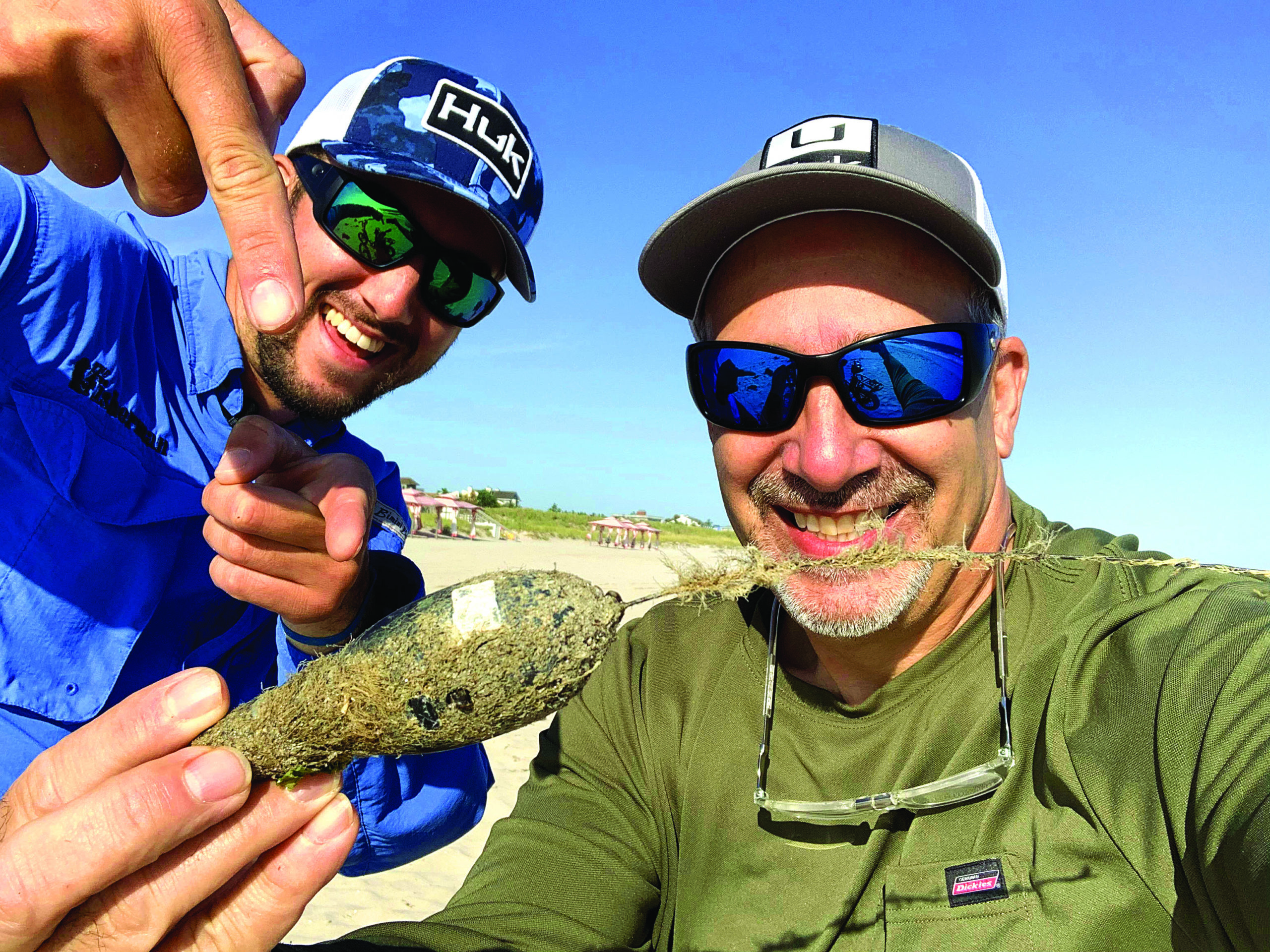
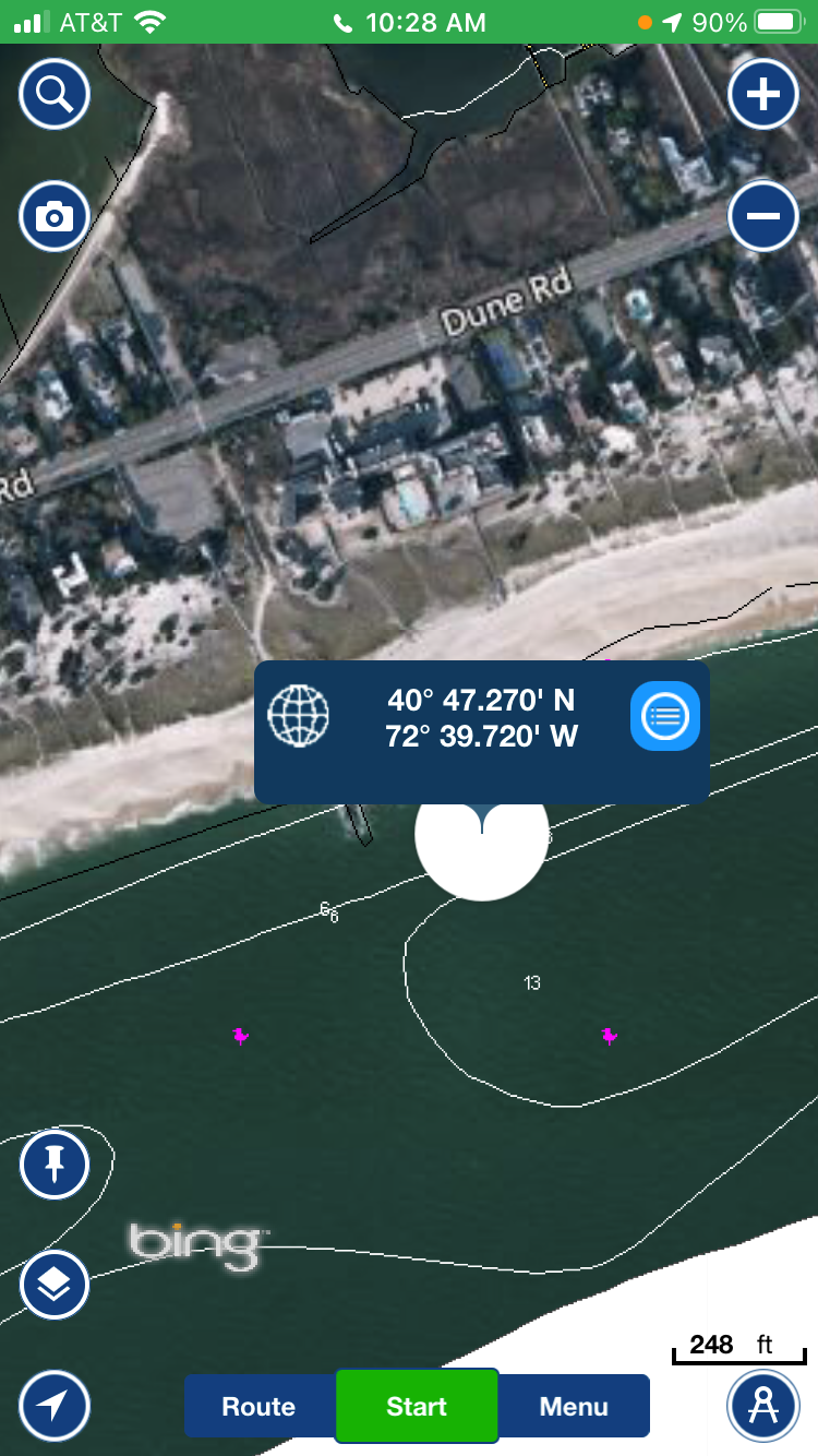
Willmer compiled several different LAT/LON numbers from the Hail Mary tag and sent me the most repetitive coordinates of 40º 47.270’ N / 72º 39.720’ W that appeared through the tracking. Plugging the numbers into my Navionics phone app and taking a screen grab, it appeared as if the MiniPSAT device was pretty close to the high tide line at Westhampton Beach. I immediately forwarded the image to The Fisherman’s Mike Caruso and Matthew Broderick on Long Island, who were on that stretch of beach later that afternoon.
I must admit, our immediate thought was for Mike and Matt to spend about a half-hour combing the beach in search of the tag with the primary plan to promote the effort on social media in hopes of getting readers out to the beach to involve in the search. We were pretty certain the tag was somewhere along a quarter-mile stretch of East End beach near the Dune Deck Beach Club, and perhaps a little online promotion would have treasure hunters successfully complete the effort for a $250 cash reward and new pair of Costa sunglasses. But 15 minutes after their arrival, the Northeast Striped Bass Study team received a text from the two Fisherman staffers, “oh yeah, we did it.”
After kicking through a weedline at the high tide mark in a stiff SW wind on the falling tide, Mike Caruso saw the antenna poking out from the sand less than 100 feet away from the LAT/LON coordinates delivered by the Argos satellite.
We Know Where You Live!
Our first 2021 retrieval was a premature tag release from the fish named Navionics. Tagged on May 24 off Sandy Hook, the battery in that MiniPSAT device activated less than two weeks later. “This tag began transferring data near Great Kill Beach in Staten Island, New York, and within a day moved to a residential location in Staten Island,” Willmer explained, adding, “this told us that the tag was originally on the beach and now was in someone’s possession possibly in their home, car, garage etc.”
As Gray FishTag Research continued watching the incoming data, the researchers were able to narrow down the final location of that Navionics tag within roughly 1000 feet along a street in the Port Richmond section of Staten Island, roughly 9 miles away from its first upload location onshore.
The ongoing and future success of the Northeast Striped Bass Study could not be possible without the generous financial support of valued 2021 national sponsors including Navionics, AFW/HI Seas, Costa Sunglasses, PENN Fishing, the Recreational Fishing Alliance through its Fisheries Conservation Trust, Seaguar, Simrad, Southernmost Apparel, and Van Staal.
And of course, there are the hundreds of The Fisherman readers and local fishing club partners including Berkeley Striper Club and the Hudson River Fishermen’s Association, not to mention the incredible individual donations by the Many and Glassberg families.
To learn more about Gray FishTag Research and how you can make a charitable donation to the 2021 Northeast Striped Bass Study go to grayfishtagresearch.org.
“As a team, we watch these uplinks and study them for a couple of days looking for consistency and movements,” Willmer would say later, explaining how tag transmissions are not fixed GPS locations and have variances up to a 1000 feet in radius, making it nearly impossible to locate, especially in a highly populated area. However, by essentially triangulating the incoming data the folks at Gray FishTag Research were able to narrow down streets and crossroads in Staten Island, coming up with the actual neighborhood where that MiniPSAT device was taken.
When William Donnelly, a wildlife photographer based out of Staten Island, used the information printed on the MiniPSAT device and contacted our team to let us know he was in possession of the tag, we had already ascertained on what street the treasure hunter lived!
Same with Tag #4 on the fish named Seaguar. Deployed on June 30 off Montauk, the data from that tag actually made its initial connection with the Argos satellite a little ways away from the water in the town of East Hampton on July 25. But the story of that tag is another East End surf surprise. On July 23, surfcaster Mathieu Palombino was fishing near Montauk Lighthouse and had just caught a bluefish when he noticed an object that looked familiar to him.
“Mathieu has been following the Northeast Striped Bass study and knew the importance of the tag,” Willmer said, explaining how once that bluefish was landed, Mathieu grabbed the tag and tucked it away for safe keeping. When he returned home to East Hampton that afternoon, he placed the tag outside on his porch realizing it might still be transmitting its data to Argos overhead, but he never contacted GFR.
“The numerous tag location coordinates were coming in strong in a residential area of East Hampton, NY,” Willmer said of the first upload results from Seaguar. “We were even able to narrow down the street that we were certain the tag was and patiently waited with the hopes someone would contact us to let us know they have our tag,” she added.
On Friday, August 13, the Gray FishTag Research office received a general email from their website stating “Hi, we found one of your tags on the beach in Montauk – no fish attached.” Today, that MiniPSAT device (Seaguar), along with two others (Navionics and Hail Mary) are now in the possession of Gray FishTag Research.
And while the MiniPSAT device from the fished called PENN has not been physically retrieved, the 14-day data upload was successful; which brings us back to the final results thus far.
Survey Says…
Now keep in mind, this is not a perfect science. The graphs we get from Gray FishTag Research and Wildlife Computers are basically averages based on both the transmitted and received data, in addition to the info stored inside each MiniPSAT device. The straight-line tracks we get are based around the highly concentrated clusters of data appearing in the charts. As such it represents the mostly likely track of a fish getting from one point of clustering to another.
But in and around these clusters – based on sea surface temperatures, depth and geolocation collected in the MiniPSAT– the algorithms used in studying the data provide us with a high probability of tracking. With my Captain Segull’s charts scattered along the floor of my office and the Navionics app open on my phone, studying these graphs show another startling set of data in the ongoing Northeast Striped Bass Study.
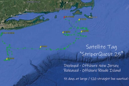
Seaguar is tagged on June 30, with the upload to the Argos satellite beginning on July 25. Soon after its release off Montauk, this 44-inch striper made its way south/southeast approximately into federal waters not far from what’s known as Butter Fish Hole (roughly 190 feet of water). Based on tracking data, Seaguar then travels 80 miles to the east to the lower tip of Nantucket Shoals before heading up past Cape Cod and in and around Stellwagen Bank by the third week in July. At about the same date that the Red Sox traveled to New York to play the Yankees, Seaguar made a hasty retreat back down to Montauk again by the end of the month. On both the trip to and from the Boston area, Seaguar can be tracked along the Nantucket Shoals area.
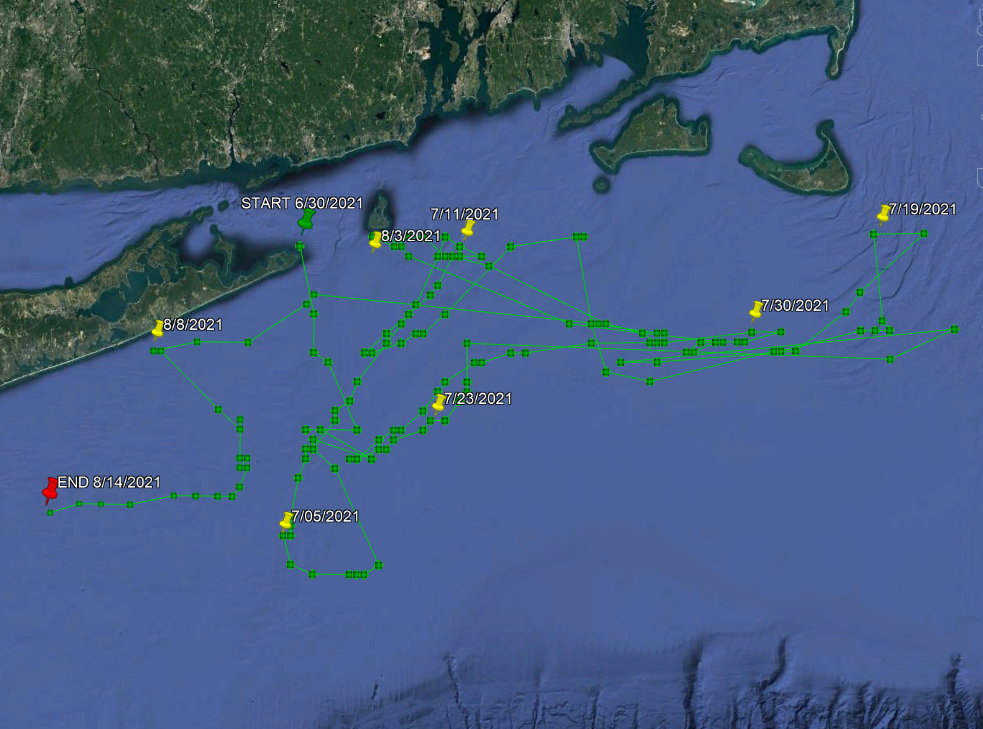
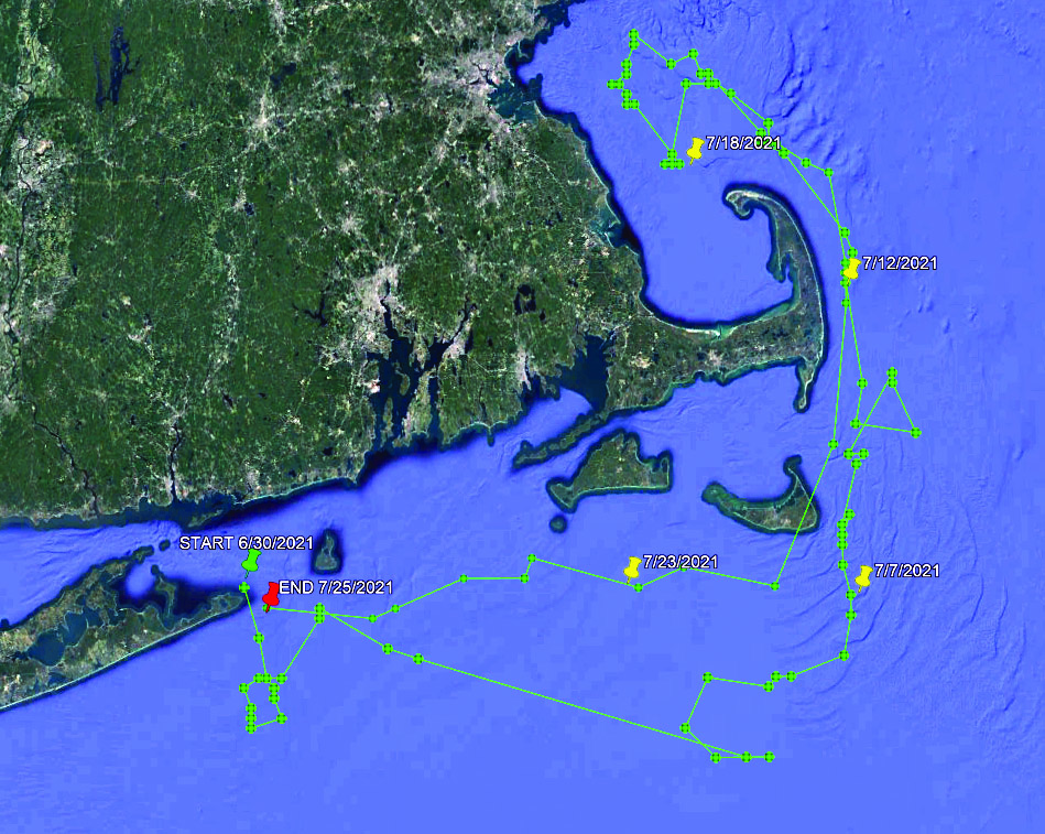
PENN is tagged June 30, with the upload starting August 24. Based on the data, the 46-inch fish named PENN made a voyage similar to that of Seaguar, except that it appears to have traveled deeper into the canyon range out past Block Channel towards areas like The Dip and the wreck of the Sea King. Interestingly enough, while PENN averages depths of 30 to 40 feet, on both July 3 and July 12 PENN shows a descent to depths of 150 feet or more before returning back closer to the surface. Similar to other MiniPSAT-tagged stripers PENN also makes its way to the Nantucket Shoals area in July and covers a lot of water between the offshore grounds and inshore waters off Block Island before the data shows a more parallel path along the south shore of Long Island from Montauk to Southampton in early August. The MiniPSAT device breaks free and begins to feed the Argos satellite on August 24 roughly 17 miles off Fire Island; the final upload came on September 4 roughly 11 miles east of Stone Harbor, NJ.
Hail Mary was caught, tagged and released near Romer Shoal on the Raritan Bay on June 17, and became the third physical tag retrieval of the 2021 tagging season. The tag was shipped from The Fisherman headquarters on Long Island to the Gray Fishtag Research office in Pompano Beach, FL where it was still uploading data as of October 6. Once the battery died on October XX, Gray Fishtag Research Willmer shipped the MiniPSAT device to Wildlife Computers in Redmond, WA where it has essentially been cracked open to analyze the data inside. We’ll have more on this particular striped bass in a future edition of The Fisherman Magazine, after the treasure trove of information has been analyzed.
As for future tagging efforts, we have two more MiniPSAT devices set for deployment in 2021. Details to follow!