 Just introduced for their growing lineup of big-screen color multi-function displays, Humminbird’s new CoastMaster cartography gives their saltwater angling customers a very special new tool in the sport fishing toolbox. Humminbird has been in the charting business for a while, so the new CoastMaster saltwater mapping this is not an overnight sensation. According to Johnson Outdoors’ (which includes Humminbird, Minn Kota and Cannon downriggers) northeast regional sales manager Tyson Alvanos says, “Humminbird is well known for their freshwater mapping division at LakeMaster. We survey our own lakes and pride ourselves on accuracy and quality. More than 10,000 lake maps can be found within our LakeMaster library, spread across 14 regions in North America, including parts of Canada. Over 2,000 lakes are mapped in High Definition and include the most accurate survey data available. Most of our High Definition lake maps were created by our own GIS survey crew who spend tireless hours mapping year round. Their information is then processed, resulting in highly accurate 1 to 3-foot depth contour maps, providing anglers with detail they can’t find anywhere else. The remaining maps in our library are standard definition and include contours typically in 3 to 5-foot intervals. Humminbird LakeMaster creates these maps by using publicly available information as a basemap, and then our GIS cartography analysts apply techniques to ensure accuracy of shorelines and update visible features. Many saltwater customers have been waiting for this same type of mapping detail, which is why we created the CoastMaster charts.
Go Fish
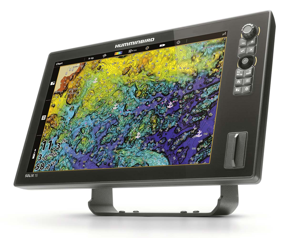
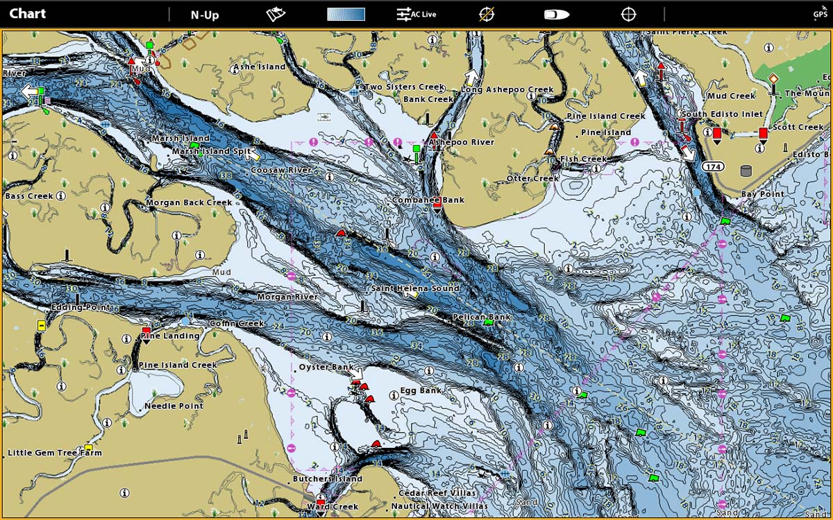
The new CoastMaster chart arms anglers with the very latest information to identify key fish-holding areas by providing accurate spot soundings, depth contours, points of interest, and navigational aids to ensure safe navigation. Anglers will also be able to monitor fishing conditions with a predictive tides and currents tool that offers details about the speed and direction of currents and the direction and height of tides for the vessel’s location. Additionally, multiple depth highlight ranges enable operators to clearly identify productive depth ranges or shallow hazard areas, plus a water level offset feature allows for the adjustment of depth contours and shorelines to match current water levels.
According to Matt Cook, Humminbird’s brand manager, “CoastMaster brings saltwater anglers the ability to quickly locate the most productive areas in any U.S. coastal waters and navigate there safely. It helps eliminate the guesswork and leads to more successful fishing trips.” Designed with ease-of-use in mind, anglers can easily adjust the CoastMaster chart to match their situational needs by selecting from the customizable view presets: Navigation view, Fishing view and a user-defined preset. With a vast offering of fishing and navigational data, the intuitive preset views make it easy to display the most important information.
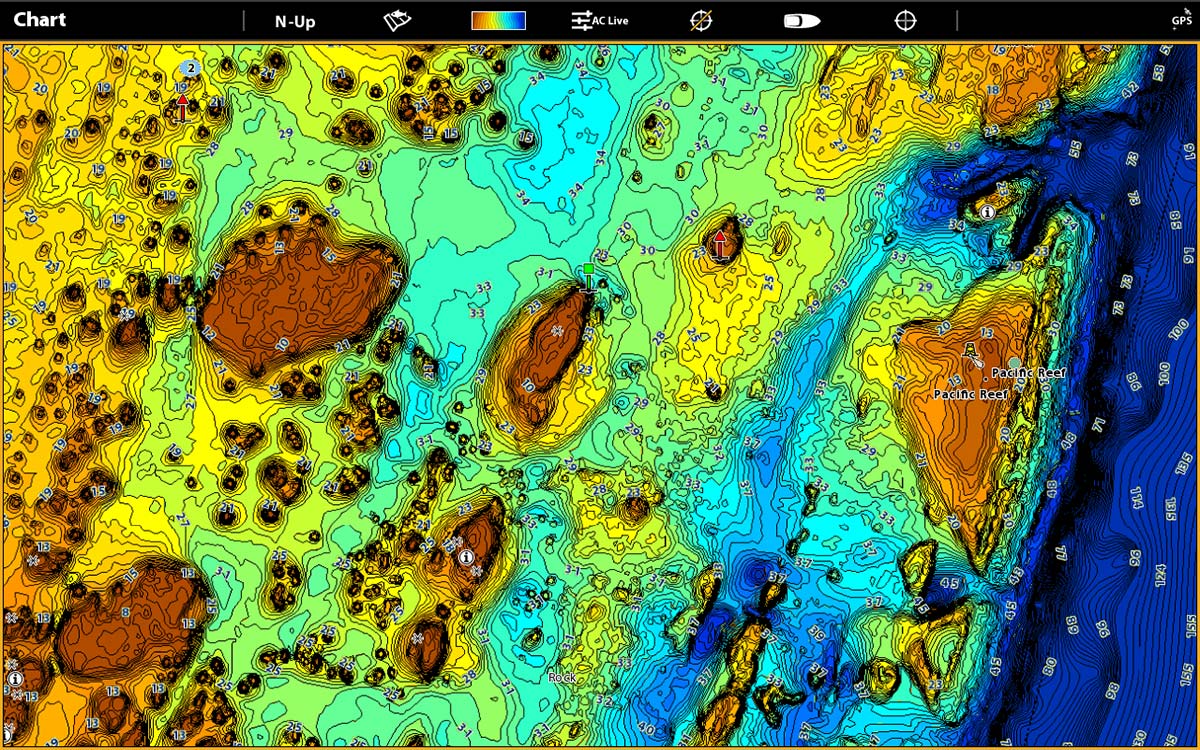
When choosing the Nav mode, the screen is less cluttered, indicating navigation markers, channels and other critical aids to navigation. When the fishing mode is selected, CoastMaster switches to a more detailed screen with 1-foot contour lines, tide stations and numerous other useful fishing features. Operators can select from multiple color palettes to match user preference.
Some of the new CoastMaster advantages include: Highly accurate data, up to 1-foot contours depending on area. Ability to highlight depth ranges in various colors so they stand out on a map (imagine catching tautog or sea bass in 45 to 50 feet of water. You can highlight this range and look for humps and contours quickly that are in the preferred feeding zone) Accurate current station and tide chart data built in. Ability to change between fishing, navigation and user modes to increase or limit the amount of data shown on your Humminbird MFD. Search and Go-To Functions (Find nearest port, find nearest wreck, etc.) This is much easier than having to scan a map with your eyes for various objects and symbols.
For those interested in even more functionality from CoastMaster, anglers can leverage the power of the One-Boat Network by pairing a Humminbird chartplotter, CoastMaster chart and Minn Kota trolling motor. With this integrated system, anglers can control all features of a Minn Kota i-Pilot Link trolling motor from a Humminbird chartplotter, including the exclusive feature of Follow a Contour, which provides the ability to set the Minn Kota i-Pilot Link trolling motor to follow a specific depth contour on the CoastMaster chart.
The new Humminbird CoastMaster is compatible with Humminbird HELIX G3/G3N and all SOLIX chartplotter models. These digital charts will be available in July 2020 and will retail for $149.99. For more information call Humminbird at 800-633-1468 or visit www.Humminbird.com/Coastmaster.