Bright lights were flashing in the sky in the area off Cuttyhunk which caused Westport Harbor residents to wonder if what they saw was a desperate last call for help of the imperiled crew of the Vineyard Sound Lightship sending out distress signals. On that violent evening of September 14, 1944 the entire coastline was ravaged by the ferocious wind and waves of a hurricane. If that was a call for help it was of little consequence other than to alert others of their jeopardy because the crew and the ill-fated ship disappeared that night never to be seen again.
For security reasons and the war effort, the loss was shrouded in secrecy and there was no mention in the national or local press. In my efforts in researching data on the wreck for our upcoming Fishable Wrecks And Rockpiles book at the time, Tim Coleman conducted the research in western Rhode Island to Connecticut while I inspected records from Sakonnet Point, Buzzards Bay and Vineyard Sound. The libraries of Fall River, New Bedford and Cape Cod provided details, most of which was found on microfiche tapes along with very old newspaper clippings. Prior to this I had been looking for that Lightship for over 10 years and it never came up on the screen of my Lowrance X-15 paper graph recorder or my backup bottom flasher. On a few very calm mornings and late afternoons when the tide was near slack we picked up a few small to medium tautog and a few legal cod on the mussels beds around her last known position, but the large image we were looking for eluded us.
It was not until September 18, 1944 that the New Bedford Standard Times published a brief mention that the Vineyard Sound Lightship was off station. Despite the fact that Cuttyhunk residents had been reporting the ship missing to local newspapers and radio stations as well as the office of the commandant of the Coast Guard; that was the only information they would confirm. While everyone along the coast was speculating about the lightships fate the Coast Guard and Navy were busy with a team of divers using the most sophisticated electronic systems available at that time attempting to locate her. One fear was that she might have been torpedoed by a German submarine. After nine days of intensive searching, Navy divers found the 112-foot ship. The masts and funnels of the massive iron ship that housed a crew of 12 were torn off, but the mooring chains were still secure leading them to believe that seawater entered the coal doors where she took on fuel and she sunk on station.
In 1958 the Fairhaven Divers Club announced plans to search for the ship. Over the next five years that group, under Captain Bad Luther, made numerous attempts to locate the ship but their equipment was rudimentary when you consider that the Navy took nine days to find it using the best the USA had in the form of sophisticated electronics. That was until one particular dive in 1963 which led to success. On that day they had Professor Harold Edgarton from the Massachusetts Institute of Technology who brought along his magic box video camera and a new side-scanning sonar device. After five years of intensive searching, using anchor drags, sleds and hundreds of marker buoys, the side scan went over the stern and began recording; in just 15 minutes they discovered the wreck!
When we began searching for wrecks there were very few of those machines in private hands, however Fisherman editor and my co-author Tim Coleman and a group of enthusiastic divers occasionally rented a side-scan unit along with the operator for a day which paid huge dividends. The only catch was that if the device became hung up in the debris field, dragger nets or rusting cables, a team of divers had to go down to untangle it.

The first wreck I discovered was by accident. It was the remains of a small wooden dragger on the northeast side of the Elizabeth Islands. At that time I was targeting stripers, and on my trips to and from the Elizabeths using the same courses I disregarded the blip on the screen which was otherwise extremely flat and muddy bottom. One morning I ran over that general location and noticed a sizable spike and turned around to examine it. My wife and son were on board, and as a light southwest wind pushed us back over the hump our three rods bent under the pressure of a large black sea bass, a jumbo scup and my son rolled a small tautog over the rail. Several more drifts resulted in multiple hookups of sea bass, scup and one short striper. I steamed up tide and set the anchor in the soft mud bottom. The wind and tide lined up perfectly, so our baits dropped right back toward the edge of the spike. We normally fished for sea bass in the deeper, much faster moving waters of Vineyard Sound, but this relatively quiet and shallow location produced our best catch yet of sea bass and jumbo scup along with a 7-pound weakfish; a catch which was quite rare at the time.
After that discovery we began dedicating an hour or two at the end of every trip to check out the nearby wreck symbols on the charts. As you are aware those symbols are PA, or position approximate; but using a dozen marker buoys we set up grids and drifted, fishing as we searched and the more fish we began catching signaled we were closer to the wreck or the debris field, even on very old wooden wrecks. Over the course of three years we ended up with well over 100 wrecks and substantial rockpiles, 75 of which we published in our book in 1989. A few of those wrecks were found rather quickly while some we had information on were never located. Even with the loan or outright gift of a draggers “hang log,” some were never discovered. The reason is when the draggers are fishing they dropped back 500 to 1000 feet or more of cable on their nets so when they hung up the numbers the skipper locked into their Loran A or Loran C machines could be as many as 10 football fields from the actual hang. At well over $3500 for a new net, very few skippers dared to chance hanging up a valuable piece of gear again, so they stayed well away from that area.
Not all of the wrecks held huge numbers of fish, but the vast majority of them provided substantial action and some of the largest specimens of tautog, sea bass and cod with some huge blues and stripers mixed-in at times as well. Despite those successes our numerous trips to the undetermined site of the Vineyard Sound Lightship were discouraging. After years of setting buoys and marking a grid, we had determined where she wasn’t, but not where she was. One beautiful summer afternoon Tim and I were heading in from a trip to Gay Head when he talked me into making one last attempt. I was tired and fished out, but I gave in. After several passes without a sign, I pushed the throttle forward and went about 100 yards when my chart recorder lit up with a huge silhouette. I made an immediate U-Turn, followed my wake and came back up on the wreck. It was almost slack tide, and on the first drop we doubled with bluefish before the lines hit the bottom. I cut some fluke strips and hooked some huge porgies and one jumbo fluke before I looked at my watch and realized I had to be back in New Bedford to meet a client for dinner.
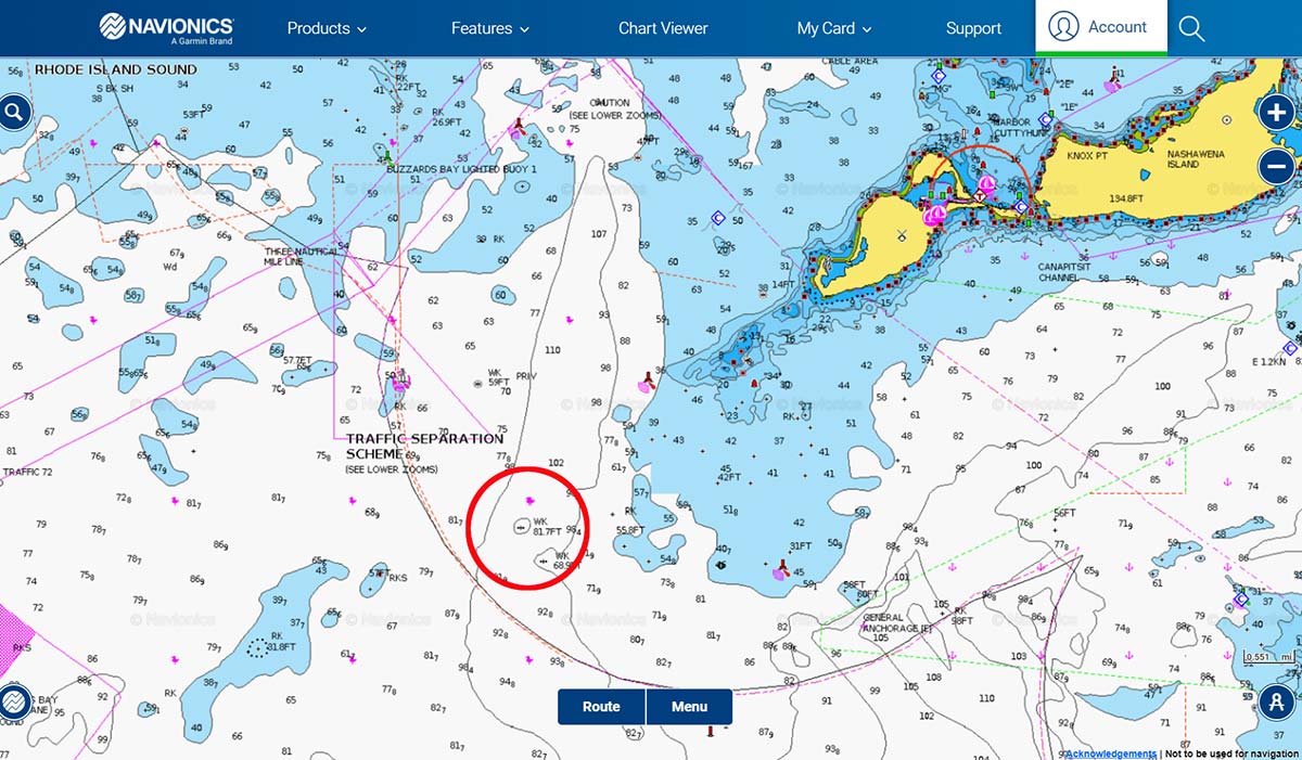
We made numerous trips back to that wreck and enjoyed some great fishing. I was using a Loran-C at the time and the repeatability of that unit was not great. This became one of our favorite spots as the Fairhaven divers said they saw some very big tog and some huge bass swimming around that wreck. Shortly thereafter I moved out of Padanaram and went back to Sakonnet and never did get my own GPS fix for that wreck, but the Loran-C numbers are 14289.6 X 43931.3. Captain Steve Abdow sent me the site that converts Loran-C to GPS. If you visit https://www.fisheries.noaa.gov/resource/tool-app/loran-conversion-tool you should come up with the GPS numbers for that and any other Loran C numbers you have. The GPS fix listed for the Buzzards Bay tower/beacon are N41-23.80 X W071-01.99 which is another great spot for numerous species. Head due east of those numbers to find the Vineyard Sound Lightship a short distance away. Refer to NOAA chart 13218.
With a sonar similar to my 12-inch Humminbird Helix unit with side scan and chirp, I’ll bet I could steam to that location and be on the lightship in short order. I don’t regret all the hours and hard work we put into locating wrecks when this concept was in its infancy; not just because of what I’ve learned but because of years of lock-and-load fishing we enjoyed on virgin pieces of structure which also includes rockpiles. Boulders and gnarly bottom grow mussel beds and marine growth which attract and hold all species of fish that provide great action as long as it is not well known and fished out by too many boats. This is not your launch the boat and drop a line fishing, it requires a bit of work but if you put in the time and effort you will be rewarded!
Editor’s Note: For more information on the Vineyard Sound Lightship, check out this month’s Hot Spot of the Month feature.