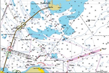
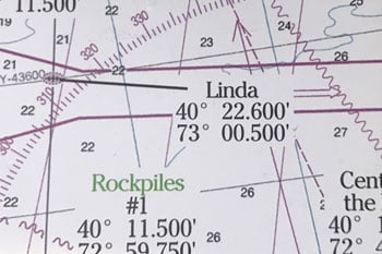
Hot Spots Archive - Page 6 of 17 - The Fisherman

hot spot

THE LINDA WRECK, NY

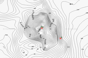
A chunk of bottom that remains a mystery lying 20 miles out of Fire Island Inlet has become known as the Linda wreck (N 40.22.524/W 073.00325) which sits on a clean piece of sandy bottom, situated upright in 135 to 140 feet of water.

TWO TREE ISLAND, LONG ISLAND SOUND, CT

The first thing the astute observer notices about Two Tree Island is there are no trees on it. “According to old timers,” said Mat Hillyer, owner of Hillyer’s Tackle Shop in Waterford, CT, “there were two trees on it at one time, but the hurricane of 1938 wiped them out.” Nonetheless, its wooded name persists.

EAST BEACH, CHARLESTOWN, RI

East Beach is a blanket term that is generally used to include the shoreline from Quonochontaug (Quonny) Breachway to Charlestown Breachway, roughly a 4.5-mile stretch of fishy shoreline.

NORWALK HARBOR, CT HERRING

While they are all often simply referred to under the blanket term of “herring,” there are three primary species of herring seen across the northeast: the blueback herring (Alosa aestivalis), the alewife (Alosa pseudoharengus), and the Atlantic or sea herring (Clupea harengus). The alewife and blueback are protected and can not be legally harvested, but the Atlantic herring may be caught and is sought for both bait as well as table fare across the region. However, at times finding large enough concentrations of sea herring locally to make it worth braving the cold in search of them can be daunting.

THE REGAL SWORD WRECK, MA

It was early September 2013, and the forecast looked good for a run “out east” as everyone seems to refer to the tuna grounds off Chatham. I was joined by New England Advertising Sales Manager, Dale Nicholson and we were fishing with Capt. John Clothier of Fish Chatham Charters. We eased our way out through Stage Harbor, turned east and shot past Monomoy Island with building seas that would eventually be my undoing (but that story is for a different day). Today our destination was for the area generally referred to as the Sword; the target waters of many of the tuna forays of the fleet based out of Chatham and beyond.

STRATFORD SHOAL (MIDDLE GROUND), CT

Sitting roughly mid-way between Connecticut and Long Island, the Middle Ground is an area approximately three miles in radius, surrounding a high spot that is exposed at low tide, and officially known as Stratford Shoal. There is a lighthouse sitting on the shoal that makes it easy to locate from a distance. Six miles north of Pt. Jefferson Harbor, Stratford (Middle Ground) Shoal (41 03 06N / 73 06 01W) consists of a variety of bottom contours creating all sorts of rip lines and drop-offs anywhere from 15 to 65 feet of water, making it an oasis for bass and bluefish, especially from late August and well into November. Diamond jigs are the top choice when drifting the rip lines, however chunking with fresh bunker while anchored up tide of the shoal will certainly put fish in the box as well.

MULFORD POINT, NY

Orient Point, NY is the farthest easterly tip on the north fork of Long Island, and it separates Long Island Sound to the north from Gardiners Bay to the south. The town of Orient is located several miles inland from the point, and it gained a reputation as a honeymooner’s hideaway early in the 20th century. In the late 1980s, Suffolk County purchased a large area of land here to help maintain and preserve the peninsula’s fragile environment of beaches, dunes and tidal marshes. Still the only way to attain the tip of the point is by a footpath, which minimizes impact to the land and offers more pristine fishing conditions.

LONG BEACH ISLAND

At the risk of being labeled a “spot burner,” I thought it best to cover an entire 18-mile stretch as opposed to any favorite bar, point or jetty. Of course, with the eight-week LBI Surf Fishing Classic slated to kick off in early October, you can expect a bit of interloping to occur regardless of what you may see in print!

NOYACK BAY, NY

Nestled between the North Haven Peninsula and Jessup Neck and southward of the western end of Shelter Island and part of the Peconic Bay estuary sits Noyack Bay.

TEXAS TOWER #4, NJ

Here’s the lowdown on why you want to add the Texas Tower to your hit list beginning this month – and why it should’ve always been there!

PATTAGANSETT LAKE, CT

Nestled between Upper Pattagansett Road to its north, and Route 1 to its south, Pattagansett Lake is a 128-acre, lazy-S-shaped body of water in East Lyme, Connecticut.

CONSTELLATION ROCK, NY

Head 2-1/2 miles southeast from the eastern tip of Plum Island and you’ll come to nun buoy 2 otherwise known a Constellation Rock.

FORTESCUE BEACH, NJ

As many of Jersey’s South/Central surfcasters turn up in force at the convergence of the Mullica and Great Bay, roughly 40 miles south as the osprey flies (and arguably a bit closer to the northern migratory arrival of spring stripers) lies Fortescue Beach along the northern bayshore of Delaware Bay.

COLLINS COVE, NJ

Rolling the dice on ice is chancy for sure when contemplating hardwater ventures in South Jersey; doubly so if said swim is influenced by the lunar-driven rise and fall of the tidewaters below the Trenton-to-Point Pleasant demarcation. Ninety-nine times out of a hundred, that’s the Mullica River, or more specifically Collins Cove.

VIRGINIA BEACH, VA STRIPERS

When cold weather finally drives the striped bass to their wintering grounds at the mouth of the Chesapeake Bay, Virginia Beach is definitely the place to be for folks looking to follow the migration.