Glory, the Pig Iron Wreck, Flour Wreck and Southwest of Astra – all are local names for ocean wrecks off Brigantine Shoal. Some wrecks date back before the Revolutionary War. One wreck out there somewhere is Glory of America, a privateer. This brigand (in the eyes of the British) came to an inglorious end during the summer of 1778. It was lost off Egg Harbor during an engagement with the Tyron, an armed vessel which sailed for England under a Letter of Marque. It was licensed by the British to attack shipping, essentially a legalized pirate.
What does this have to do with the wreck known locally as Glory (Site #6, Chart 1)? Absolutely nothing! But it recalls the many wooden vessels that were lost to war, weather, and marine accidents off Egg Harbor.
243 Years & Counting
During the Revolution, the whole area was a hotbed for seizing merchant vessels. This activity led to the British burning of Chestnut Neck along the Mullica River. Chart 1 shows some of the more prominent wrecks which are sandwiched in between the Little Egg Reef to the north and the Atlantic City Reef to the south. File numbers from the Coast Survey’s Automated Wreck and Obstruction Information System (AWOIS) are listed as available. Wreck and local names are shown in parentheses. Wrecks shown in red are illustrated with images. There’s certainly a lot out there to prospect for reef fish.
Hydrographic surveys still find uncharted and unidentified wrecks offshore, although the early wooden wrecks are most likely fragments today or depressions where remains once rested. Such is the case for the 65-foot Newfoundland schooner Sadie and Edgar (AWOIS #11199) which sank on the north side of the Brigantine Inlet bar (Site #2) according to a Notice to Mariners in 1974. The AWOIS viewer records 4 feet of the mast showing in 2002. A later field survey, documented in National Ocean Service (NOS) Descriptive Report (DR) H12597 (2014), reports no evidence was found of the wreck. This is not surprising considering the high energy inlet location. The charted wreck symbol coincides with a depression that appears in “DEM” Color Shaded Relief image when using the Bathymetric Data Viewer (BDV). This National Oceanographic and Atmospheric Administration (NOAA) web application is a valuable resource that provides access not only to bathymetric montage images, but also to the underlying hydrodynamic survey data and reports.
BDV “BAG” Color Shaded Relief image coverage for this reach of the New Jersey shoreline is limited to a narrow band along the shoreline. Most wrecks are farther offshore, although one is covered by the BDV just outside Beach Haven Inlet and one outside of Brigantine Inlet. The wreck of the 36-foot tug Vinnie V (AWOIS #11196) which went down in 1986 is located north of the Beach Haven Inlet entrance close to shore (Site #1).
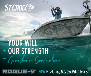
DR H12597 includes side-scan and multibeam sonar images which provide more detail than the BDV “BAG” Color Shaded Relief image which is also available (see Chart 3). As of the 2013, the wreck rose about 5 feet off the bottom. The wreck position shifted from its original position. This condition is also not surprising given its relatively small size and location in the high energy inlet zone as seen in Chart 2.
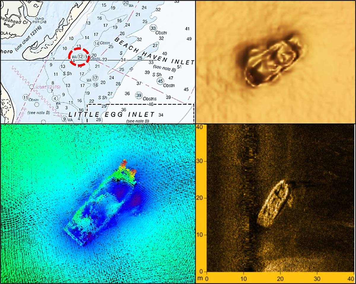
The wreck outside of Brigantine Inlet (Site #3) doesn’t have an AWOIS number. It is included in DR H12597, which reports dimensions of about 70 feet long and 50 feet wide with a rise of about a foot and a half above the bottom. The wreckage presents in the BDV “BAG” image as a possible sailing vessel with what appears to be a bowsprit. As shown in Chart 3, the back portion appears sanded in. The feature is recorded as an Electronic Navigation Chart (ENC) wreck in the AWOIS Interactive Viewer with no other identifying information. This wreckage is close to shore and looks promising. But, it’s also in the high energy zone where pounding by storm-generated waves and covering by sand movement pose continual threats to bottom structures. Nevertheless, it’s worth checking out when passing through the area.
Technological Spot Burn
NOS DR H11242 (2004-2005) documents three unidentified wrecks that provide substantial “accidental” fishing reef structure. One, charted as a 67-foot wreck in 80 feet of water, is the so-called Southwest of Astra (Site #19). A multibeam sonar image included in the report shows a mass of scattered wreckage southeast of the Astra charted position (Site #18), as shown in Chart 4. Anecdotal information from diver websites suggests and a side-scan sonar image by Peter Straub of Stockton University (included on Chart 5) confirm that the Astra may be in two sections with one slightly east of where charted. Perhaps this accounts for the local-name southwest reference for the 67-foot wreck.
The other two unidentified wrecks shown on Chart 4 may have local names, but they didn’t turn up during the literature review for this write-up. Search resources used were the New Jersey Maritime Museum’s wreck database, the AWOIS Interactive Viewer, and wreck coordinates published by multiple sources. The result – no candidates for vessel names in the general proximity of the coordinates recorded by the NOS survey team. These two wrecks present in multibeam sonar images as intact and 300 feet or greater in length. The northernmost of the two (Site #7) is charted as a 40-foot wreck. It bears 099° True, 4.8 nautical miles from Brigantine Lighted Wreck Buoy WR2. A BDV “BAG” Color Shaded Relief image is not available. The BDV “DEM” Color Shaded Relief image shows a large mound.
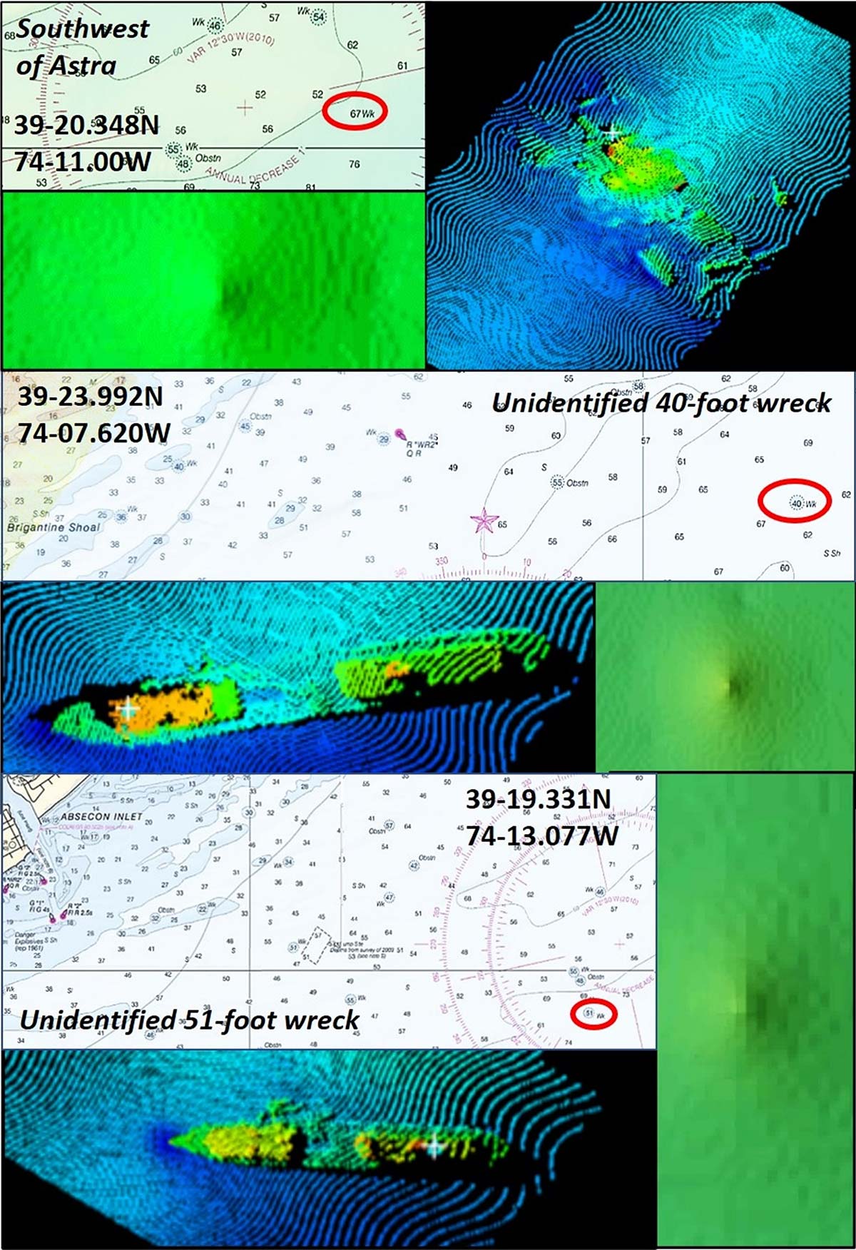
The other unidentified hulk (Site #16) is charted as a 51-foot wreck. It bears 174° True, 5.5 nautical miles from Buoy WR2. A BDV “BAG” Color Shaded Relief image is not available for this one either. The BDV “DEM” Color Shaded Relief image shows a large mound. Maybe they’re fished and dived on, but if so, I didn’t find any Internet chatter. Neither shipwreck is identified on diver websites, which is curious. If there’s a wreck out there not too deep and not too far offshore, divers would normally be all over it! The NOS DR is available, but my guess is that they’re not widely accessed, and the wrecks slipped through the awareness gap! If they’re closely held spots, the NOS DR let the cat out of the bag. Regardless, the two unidentified shipwrecks provide substantial structural habitat for bait and predators and thus fishing opportunity.
Perhaps the two identified wrecks have local names that I missed, or maybe there are mistaken identities and conflicting coordinates (there are a large number of wrecks relatively close together). For example, the Lemuel Burrows, also known as the Collier, was incorrectly recorded in the Navionics Community Layer as the site of one of the unidentified vessels just discussed. The Lemuel Burrows was torpedoed by a German U-Boat in 1942 and sank with loss of life. The hulk was wire swept to clear it as a hazard to navigation in the coastal shipping lanes. Today, the remains are a distributed mass on the bottom. The Lemuel Burrows bears 193°True, 6.8 nautical miles from Buoy “WR2” (Site #14). There are also some wrecks, especially prior to modern electronics, for which coordinates are not known or were only accurate to a mile or more.
Stockton Sampling
Inshore to the northwest of the Collier are the Coal Barge/PET Wreck (AWOIS #1318 / #13), Eugene Moran (AWOIS #11189 / #9), the Pig Iron Wreck (AWOIS #1327 / #11), Car Float (AWOIS #1322 / #10), and even closer to shore, the tug Patrice McAllister wreck (AWOIS #1351) just southwest of Buoy “WR2”. Note that the Eugene Moran is listed in AWOIS at two locations, Sites #9 and #12 on Chart 1. One of these is in error, but I didn’t find any images to help resolve the inconsistency, although Site #9 has the more complete descriptive history.
Side-scan sonar images of the Glory (possibly the Gloria or Lake Frampton), Almirante (“Flour Wreck”), Astra, “Car Float”, “PET” Wreck, and Patrice McAllister are posted on the Stockton University and njscuba.net websites. (Note the same local name is sometimes applied to multiple wrecks. For example, there is also a “Car Float” wreck off of the Wildwood Reef. Also, note that the Stockton University “PET” Wreck side-scan sonar image plots where AWOIS #1318 describes what the file refers to as the “Coal Barge”. These inconsistencies may be associated with positioning error factors.)
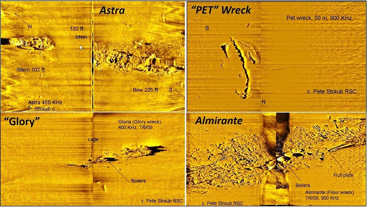
Side-scan sonar images of three additional wrecks are also shown by Chart 5 courtesy of Stockton University Marine Field Station. Many of the wrecks the NOS survey team and Stockton University professors and students examined, as well as wrecks discussed on diver websites, are distributed – that is, scattered – on the bottom. Dispersal of wreckage debris is the result of damage from marine casualties or naval engagements, natural deterioration, wire dragging, use of explosives to clear the wreckage as a hazard to navigation, or in the case of the Almirante (Site #17), depth charging.
According to several diver websites, an aircraft observed something underwater resembling a U-boat early during World War Two. Five depth charges were dropped on the shadow by the Coast Guard. It was the Almirante! The depth charging adding to wreckage dispersal that had resulted from prior use of explosives and wire drags. The wreck is a favorite diver training site because it is relatively shallow, has low relief, occasional artifacts, and fish and lobsters.
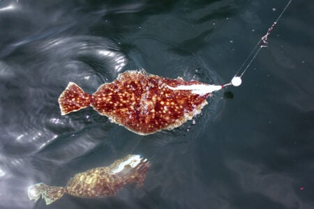
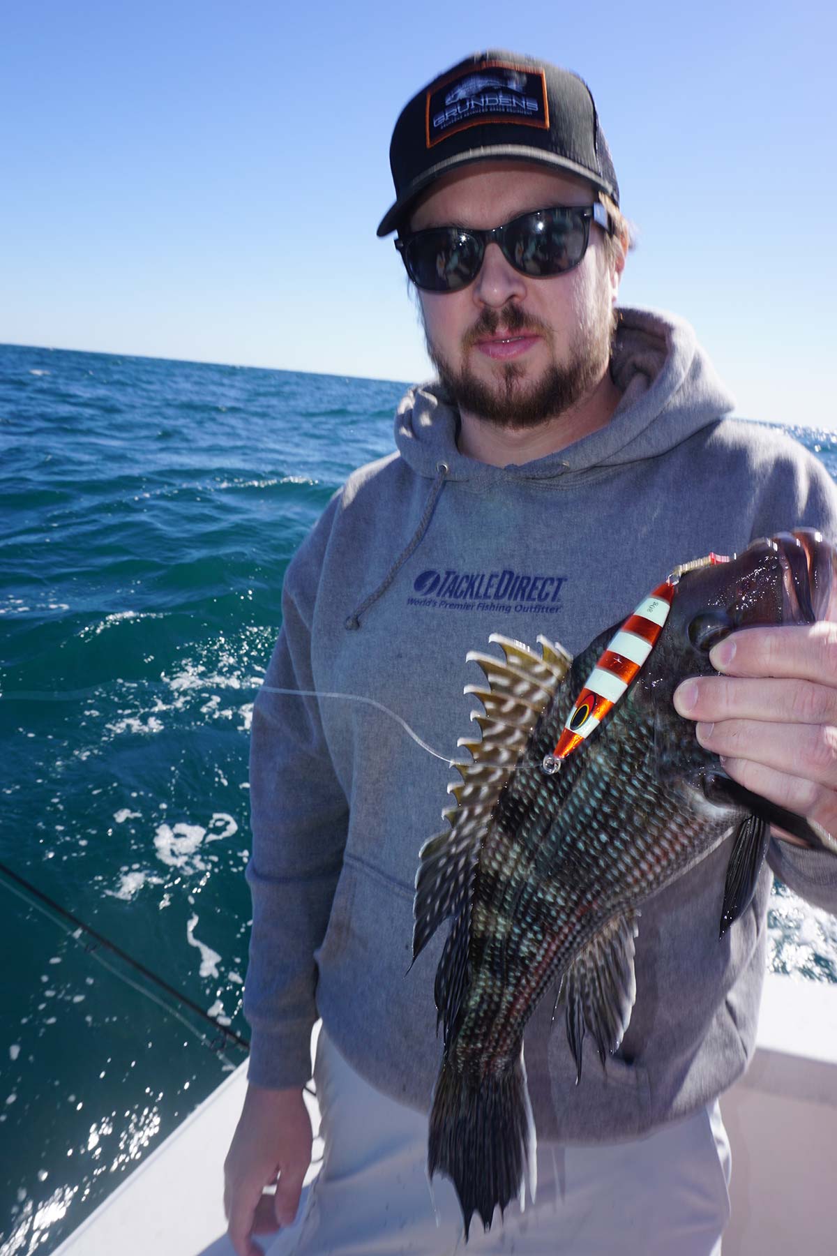
Fish to look for at these and any of the other wrecks discussed include the usual suspects – tautog, sea bass, and summer flounder. Look for other foraging predators seasonally according to migration and summer foraging patterns.
Wayne Young is a former manager of the Maryland artificial reef program for Chesapeake Bay waters. He is the author of “Chesapeake Bay Fishing Reefs: Voyages of Rediscovery” available on Amazon.com. His Facebook page is Chesapeake Bay Fishing Reefs. Look for NOAA’s Bathymetric Data Viewer at https://maps.ngdc.noaa.gov/viewers/bathymetry.