Our Bathymetric Data Viewer series returns for fall of 2021 into the New Year.
“BAG” and “DEM” Color Shaded Relief images displayed by the Bathymetric Data Viewer are now available as user-selectable overlays by some commercial electronic chart products and applications. Some products may include additional proprietary sonar data for certain areas. Screen resolution varies by product and screen resolution. Resolution is generally sufficient to assist in navigating to bottom structure. “The BDV chart display was recently updated to Electronic Navigation Chart (ENC) format and is now available at all zoom levels. A more brilliant color palette was used for shaded relief imaging and depths were changed to the Metric system. Most wreck and obstruction symbols were replaced by sounding “circles”. This write-up uses raster charts showing the former wreck symbols.”
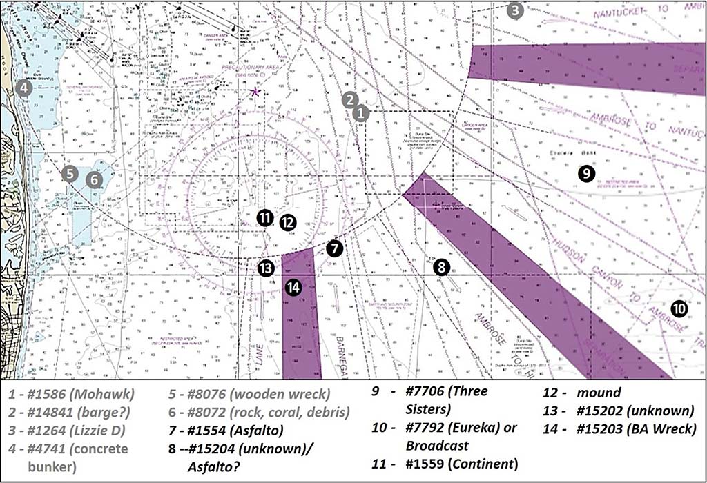
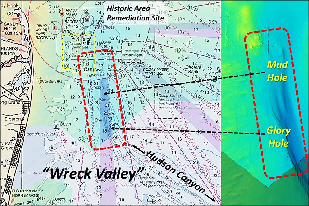
Hudson Canyon is known to divers and recreational fishermen as “Wreck Valley” for the many shipwrecks found there. The approaches to New York harbor claimed many maritime victims as well. Chart 1 shows the location of the more prominent wrecks in New York Bight (Sites 1-6) and Wreck Valley (Sites 7-14). Sonar imaging was found for the features shown by black circles on Chart 1.
The valley is the geological bed of the Hudson River dating back eons to when the sea level was much lower. Over time, the river bed east of New York Harbor’s Lower Bay progressively filled in with sediment. The channel filled in down to the existing northern end of deep water at the head of a steep ravine where it widens and falls into the ocean abyss.
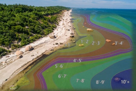
The northern end of the valley, shown by Chart 2, is a very productive fishing area called the Mud Hole. Moving south southeast of there, depths quickly drop off into the Glory Hole. Look for a very steep drop-off on the western side. Then, the canyon runs towards the southeast out to the edge of the Continental Shelf.
Bathymetric highs mark the western edge of the ancient river bed north of the Mud Hole. These high areas are visible Bathymetric Attributed Grid (“BAG”) Color Shaded Relief imaging using the National Oceanographic and Atmospheric Administration’s (NOAA) Bathymetric Data Viewer (BDV). This data is accessible without cost and is also available in some commercial products (see below, NOAA Data User Access.)
Many of the Wreck Valley sites are well-known fishing hotspots. Most are well-documented by diver websites in terms of what’s there, including Rich Galiano’s njscuba.net and Capt. Dan Berg’s aquaexporers.com. But, there is some mystery about which vessels are really there, not the least of which is the Asfalto.
Searching For Asfalto
According to a Steamboat Inspection Service Report cited by Record #1554 in the Coast Survey’s Automated Wreck and Obstruction Information System (AWOIS), the barge Asfalto was under tow by the tug Reliance. The barge struck a submerged object and sank in 1932. The location recorded in AWOIS is shown on Chart 3 as Site 7. However, the originally reported sinking location (at the Mud Hole) had a position error of up to a mile. The wreck AWOIS recorded has never been positively identified. An anomaly where the wreck is charted is also identified as the N. W. Irmac. What is known for sure is that Asfalto was a schooner barge that struck an object and sank.
We also know what it looked like from a detailed writeup on aquaexplorers.com where an excerpt from Capt. Dan Berg’s Wreck Valley CD ROM posted there (also at njscuba.net) contains a description. Dive boat Capt. Berg describes the Asfalto as a 300- by 40-foot steel-hulled schooner that was converted to a barge. It’s also referred to as the Cindy, Rudder, and X-Ray Wreck.
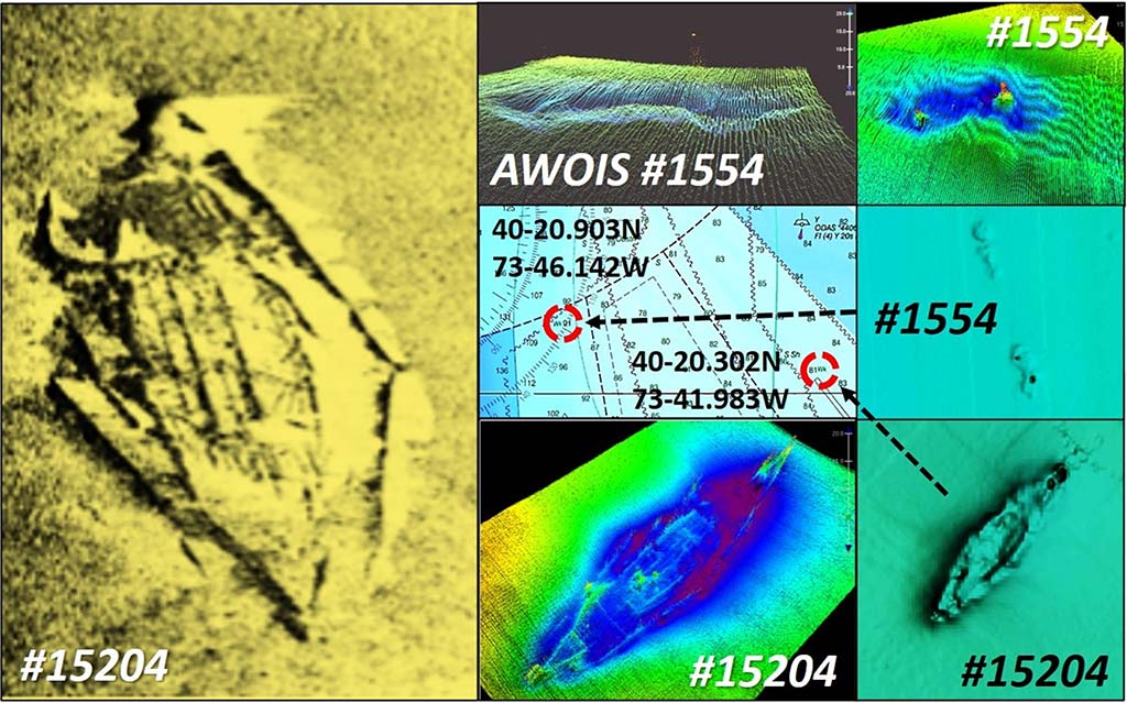
Shown as Site 7, the wreck was investigated during a 2013 hydrographic survey. It was located using Loran C coordinates (see below, Source of Loran Coordinates). Multibeam sonar imaging included in National Ocean Service (NOS) Descriptive Report (DR) H12627 (2013) for #1554 shows two depressions. It is thought the perhaps there are two wrecks at the location and that the tug towing the barge may also have sunk there. A broad range of artifacts have been recovered from this wreck by recreational divers, resulting in the conjecture that the wrecked vessel was used as a garbage dump barge for New York City trash.
Marine historians and archeologists decry souvenir hunting because this practice destroys historical and cultural value. They also have found many historical wrecks damaged by fishing gear and anchors (which is how some of the wrecks were discovered). Snagged artifacts should be turned over to state archeological authorities for preservation and conservation. We should also avoid anchoring in old wooden wrecks to avoid damaging them and losing our anchors.
Although aquaexplorers.com reports that the vessel’s bowsprit was once encountered, color imaging of multibeam sonar data for #1554 doesn’t show anything like that. However, multibeam and side-scan sonar imaging reveals that 3.3 miles to the southeast at Site 8 lies an unidentified wreck with a schooner profile, AWOIS #15204. Diver descriptions better fit this wreckage, which is also about where a njscuba.net map shows the Asfalto. A BDV “BAG” Color Shaded Relief image also shows a schooner profile with dimensions that are consistent with those given by Capt. Berg. NOS DR H12627 included the color multibeam and side-scan sonar image shown on Chart 3.
The DR reported that the wreck deteriorated. However, there is a lot more showing at #15204 than at #1554. Plus, the schooner structure attracts a lot of marine life, according to diver reports. AWOIS is known to contain errors and inaccuracies. Some no doubt the result of positioning inaccuracies of original reports. AWOIS #15204 is the better candidate for Asfalto.
More Mud Hole Wreckage
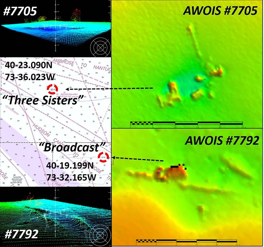
Northeast of Asfalto on Cholera Bank (Site 9) is AWOIS #7706, an unidentified wooden-hulled wreck known as Three Sisters. NOS DR H12629 (2013) reports that the wreck is broken and dispersed. Color multibeam sonar images from the DR included on Chart 4 shows the distribution of visible remnants. Diver reports indicate there are some beams and planking, a boiler, and a propeller. Divers also report that it is a decent spearfishing site – think tautog and sea bass!
Southeast about five nautical miles at Site 10 is another unidentified wreck, AWOIS #7792, known as the Broadcast and the Eureka. Chart 4 shows the location and includes more color multibeam images, also from DR H12629. There is a great drawing of the Eureka site layout by Capt. Berg that is posted on aquaexplorers.com along with a side-scan sonar screenshot. Once thought to be the 128-foot tug Eureka, historical records say that vessel was actually scrapped. The current thought is that the wreck may be a clam dredge. There is a substantial debris field consisting of a mast, shaft, deck gear, and boiler. The latter are reported to rise as much as 10 feet off the bottom. The wreck holds lobsters and provides structure for sea bass and tautog.
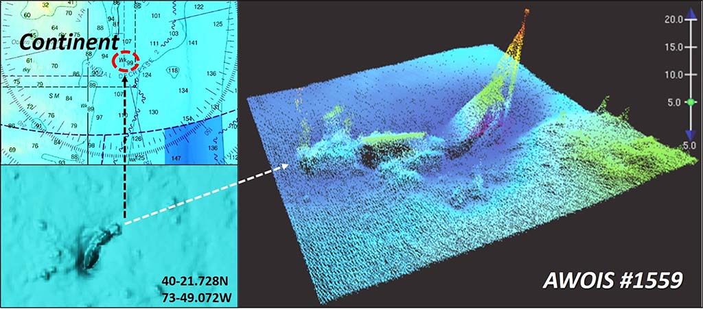
Northwest of Site Seven 2.7 miles at Site 11, just inside the southeast corner of the Historic Area Remediation Site (HARS) boundary, is the wreck Continent. It was a small 149- by 25-foot freighter that sank following a collision in 1942. The hull is broken amidships and is partially buried. Color imaging of multibeam sonar data in DR H12627 and a BDV “BAG” Color Shaded Relief image shows much of the vessel in a scour hole. To the east, at Site 12 on Chart 5, you’ll see a broad mound.
The National Ocean Service hydrographic survey that investigated and located the Asfalto wreck site used Loran C rates provided by Richard Taracka of the Greenwich, CT, Police Department. He is broadly credited by AWOIS for providing Loran C Rates for many shipwrecks in Wreck Valley. Hydrographers, divers, and recreational fishermen are indebted to him for the many wreck coordinates he provided which informed hydrographic surveys and the production of nautical charts.
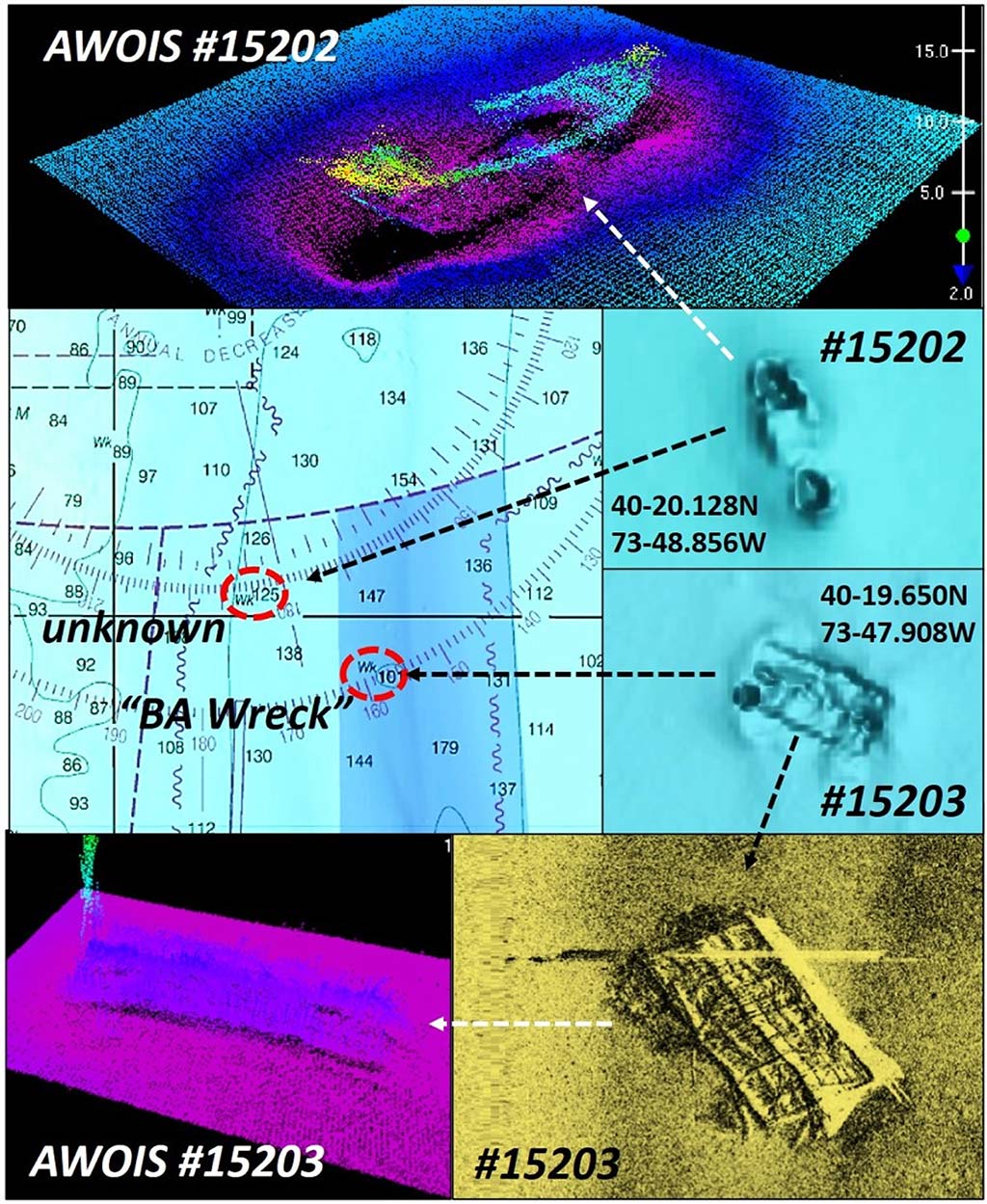
West southwest of Site 7, about 2.3 miles is a small unidentified wreck at Site 13. The wreckage appears intact in both a color multibeam sonar image from DR H12627 and a BDV “BAG” image. A more important unidentified wreck is located 1.8 miles southwest of Site Seven at Site 14 in the Traffic Separation Zone. Known as the BA Wreck, this site is a fishing hotspot. Be aware that divers report the wreckage is festooned with monofilament. The BDV “BAG” color multibeam sonar and side-scan sonar image of this wreck shown in Chart 5 reveal a rectangular barge profile. Planking is missing, and most of the frames are exposed.
The BA Wreck is a place to start when fishing out where the Ambrose-Barnegat and Ambrose-Hudson Canyon Traffic Lanes intersect with the Precautionary Area. It holds fish and is out of the traffic lane. Regardless, when seagoing ships are in the area, keep an eye out for large bow and stern wakes and give them plenty of maneuvering room.
Aside from that—and the weather—enjoy the wreck fishing!