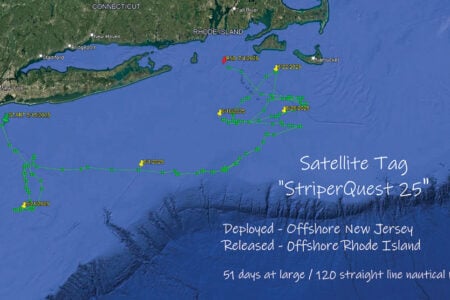
The first satellite tag results of 2019 are in with tales from the edge!
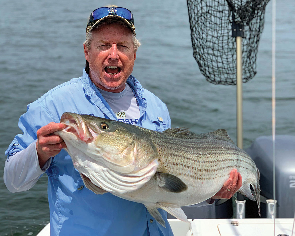
On May 21, 2019, a team of ardent anglers and researchers comprised of The Fisherman, Navionics and Gray FishTag Research staffers set upon New York Harbor to deploy a pair of satellite tags in post-spawn striped bass. At approximately 1 p.m. on the outgoing tide, two days past the full moon, the first satellite tagged striped bass – a 34-incher, which our team named Liberty – was released back into the harbor.
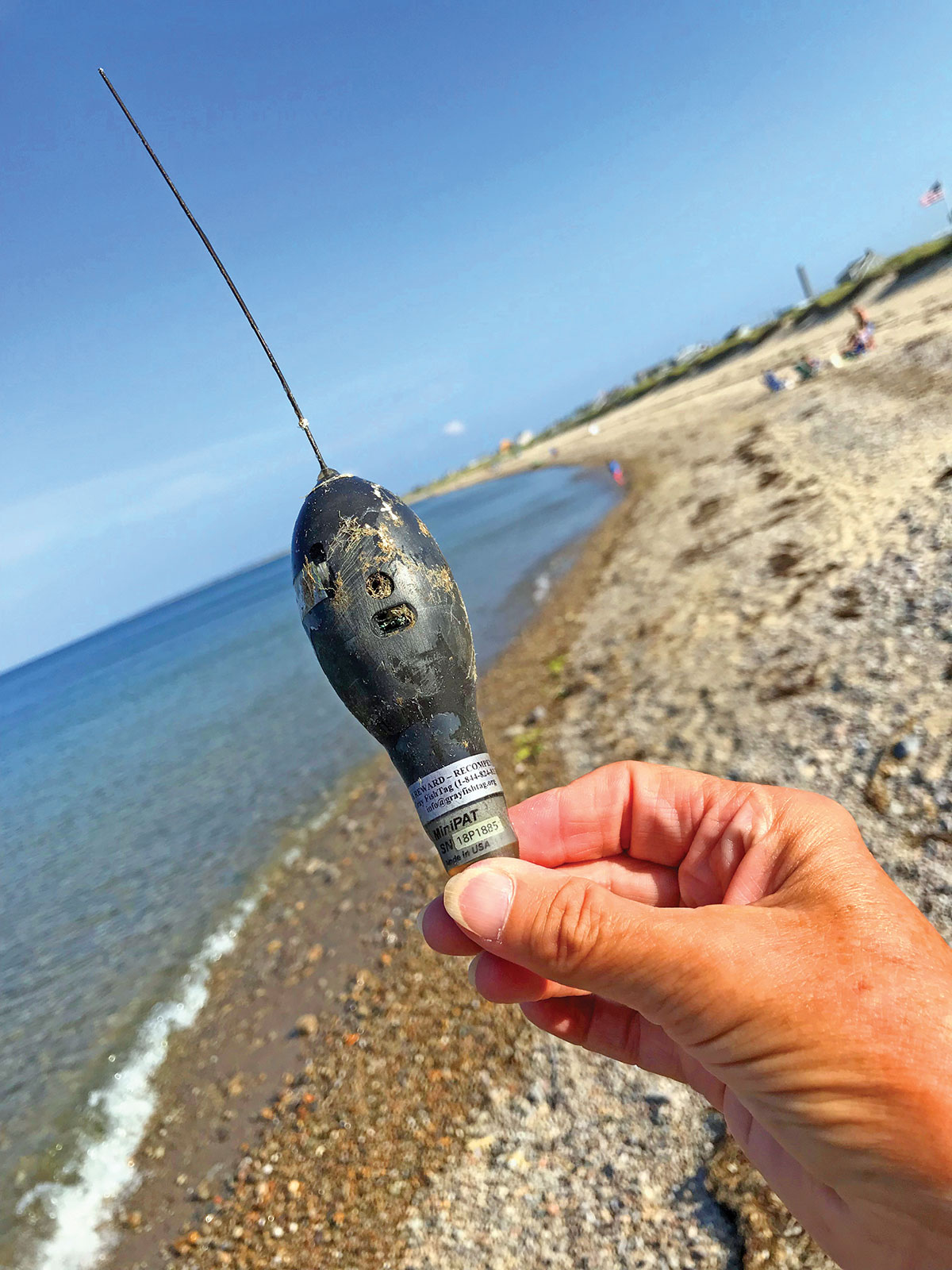
You know all about the best-laid plans; the Wildlife Computer MiniPAT tag deployed in Liberty (a second inserted several hours later into a 42-incher named Freedom) was programmed to “pop off” on October 21. Unbeknownst to Gray FishTag Researchers at the time, Liberty’s tag came free on July 9. The tag began to float freely, and guided by winds and current, it evidently, ultimately ended up along a Massachusetts beach.
“A woman walking the beach recovered the tag and contacted our office,” said Gray FishTag’s Bill Dobbelaer. “She was kind enough to overnight the original tag to us and in return she received a financial reward as well as a pair of 580 Costa Del Mar sunglasses.”
Having a MiniPAT tag physically returned is a little like finding the proverbial needle in a haystack; of course, with all the secrets contained inside that watertight globe, it could be more like the genie in a bottle. By design, the tag once freed from the fish, will float to the surface where it relays summaries of stored data via satellite.
Since Liberty’s tag came off a bit premature, no one back at Gray FishTag Research was actually looking for the data just yet. When Dobbelaer’s crew got the call and received the actual tag, it began a frenetic and extensive process of work with marine biologists and technicians at Wildlife Computers to compile the amazing amount of data the tag collected.
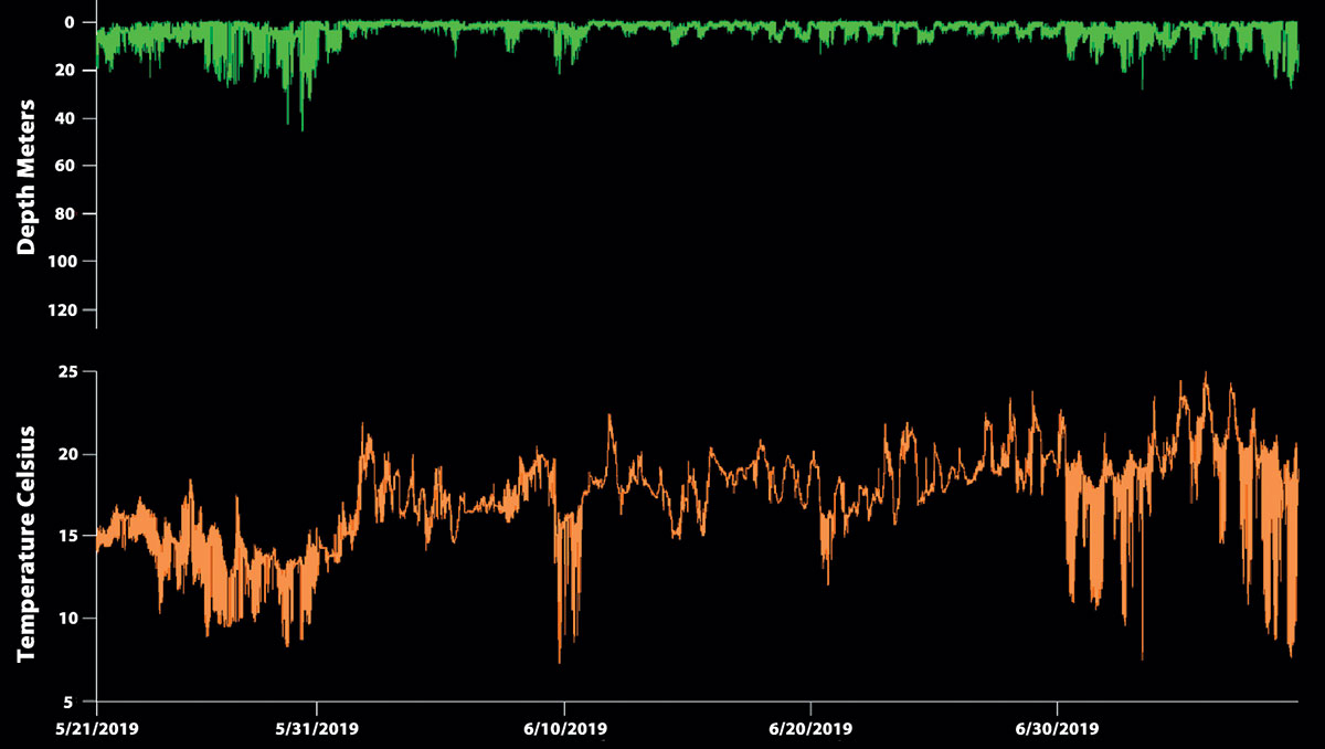
“In satellite tagging, we typically must wait for the tag, which was deployed to release and the data to be transmitted through Argos satellites,” said Dobbelaer. “In this case what was exceptional is the fact a woman physically recaptured the actual tag at the Cape Cod Canal near Sagamore Beach, MA providing us with the opportunity to obtain the entire data set. As a result of the finding of the actual tag our data points were recorded in 15-second intervals.”
Each of the satellite tags deployed have three components to collect data:
Tracking Data: Light-based Geolocation
Diving Behavior: Time-at-Depth Histograms
Temperature Profiles: Profile of Depth and Temperature
In the case of Liberty, the data stored inside her MiniPAT tag show that at no time between May 21 and July 9 did the tag ever lose all three components of light, temperature and depth. That means our tagged striper wasn’t harvested during that timeframe, she wasn’t consumed by a larger predator, and she didn’t simply die and drift along with the currents for two months.
So where was Liberty for those 49 days after her catch and release in New York Harbor? The tracking results may surprise you; they may surprise a lot of people.
Ryan, Nantucket & Clipper
First it’s important to note that the folks at Gray FishTag Research have conducted similar satellite tagging studies on roosterfish, striped marlin and swordfish with pretty significant results. This is the first time that Gray FishTag researchers however had employed a MiniPAT in striped bass, and it’s the first time that it has ever been done on a longer duration effort with striped bass.
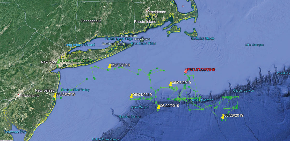
“We must always remember that fish in the ocean or wild never swim in a straight line,” Dobbelaer said, adding “the graphs you see are averages based upon light sensors, temperature and depth information.” In a nutshell, it has taken an experienced team to process the millions of data points to compile averages of physical data in order to create graphs showing Liberty’s movements between May 21 and July 9.
According to the stored data, after a quick trip down along the Jersey Shore, Liberty traveled in a northeasterly direction in federal waters towards the South Shore of Long Island where she spent Memorial Day weekend well off the beach in depths to 100 feet or more. She then meandered in a south/southeasterly direction, spending most of June in parts of Ryan, Nantucket and Clipper canyons, cruising mostly in the 40- to 80-foot depths.
“Based upon the three types of data collected this information has shown and we were able to collaboratively state with great certainty that Liberty has traveled over 300 miles (straight line) from New York in an eight-week period spending most of the time in offshore waters following the contour edge of the continental shelf in the Northeast, also known as the canyons,” Dobbelaer said.
Fact Or Fake News?
Are all striped bass spending parts of the year in the canyons? Scientifically, statistically, that’s impossible to say. “This striped bass study reflects the movement of one fish caught and released in the Hudson River mouth and draws no conclusion of all striped bass behavior,” Dobbelaer warned. “However, the groundbreaking movement lets us know that further work is a necessity from the team at Gray FishTag Research. There is so much more research that needs to be done to study the current patterns and movements of striped bass.”
In the ongoing debate on striped bass management, many coastal fishermen believe that stripers are spending more of their time outside the three-mile line in the exclusive economic zone (EEZ) where they’re protected against harvest. The latest benchmark stock assessment on striped bass, the basis for ongoing management response by the Atlantic States Marine Fisheries Commission (ASMFC) even cites a North Carolina Cooperative Winter Tagging Program that suggests that striped bass distribution on their overwintering grounds has changed significantly since the mid-2000s.
“The migratory portion of the stocks has been well offshore in the EEZ, requiring travel as far as 25 nautical miles offshore of Chesapeake Bay to locate fish to tag,” the report stated, though it also noted how acoustic telemetry work on adult fish that aggregate on Stellwagen Bank located in federal waters and beyond 12 nautical miles also move inshore as part of their normal migratory and feeding behavior.
The accepted research acknowledges that striped bass are spending more time offshore in waters where they’re protected against commercial and recreational harvest; yet it also says that spawning class fish must travel inshore at some point during for the spawn, which is where it’s hoped that catch and trawl surveys will intercept them for ongoing stock assessment efforts. Because those particular survey results have been so poor, it’s proof as per ASMFC that the spawning stock biomass of striped bass is indeed below the threshold for being considered overfished.
So yes, perhaps we’re not seeing sustained coastal striper runs when and where we’ve historically enjoyed a great fishery. But by the same token, those spawning class stripers are programmed to return inshore to the bays and estuaries at some point to perform their evolutionary magic; Liberty may be a scientific example of that very fact, even if she may have spent time with the tuna and billfish offshore.
Reducing Uncertainty
Is there a degree of error in this study? Of course, there’s a certain degree of error in every scientific study. But the technology incorporated into the Wildlife Computer MiniPAT tags used for this study are about as high tech as you could possibly get in a $5,000 research device. “In all fish telemetry, there is always a small margin for error,” Dobbelaer noted. Then again, in this case of the very first tag return actually being physically returned for comprehensive analysis, Dobbelaer calls that margin of error “minimal in this study due to the fact we physically recaptured the original satellite tag.”
This shouldn’t be considered groundbreaking enough to hold up or interfere with the ASMFC striped bass decision for 2020. The Fisherman’s Publisher Mike Caruso, one of the project partners, said there’s a lot more to accomplish through this ongoing effort. “We believe there’s valuable data here for the future, and our hope is that we’ll be providing more of it on an annual basis through upcoming satellite tagging efforts,” Caruso said, adding “it’s our hope that fisheries managers will find this data valuable to their ongoing work.”
And as Dobbelaer noted, this is still just one tag. “At this time, the second striped bass tagged named Freedom is still at large,” Dobbelaer said in late September while analyzing Liberty’s data. “We anxiously await the reporting of Freedom and will share the information once collected.”
All the data collected by Gray FishTag Research is open access and available to the public when requested in writing. Our ultimate goal as a team is to continue to satellite tag many more striped bass in the lower Hudson River during the same time of year in an effort to control the data collected on these great fish. As more “investors” are brought aboard and additional charitable “contributions” from the general public are collected through the not-for-profit Gray FishTag Research, the team hopes to grow the satellite tagging project throughout the region, with future efforts focused on the Chesapeake and Delaware as well.
And whatever data is compiled through this ongoing collaborative research, it will be made available to the public via GrayFishTagresearch.org and hopefully welcomed by ASMFC and NOAA Fisheries for better understanding of the striped bass fishery as a whole.
Now, where have you gotten off to dear Freedom?