Our continuing “BDV” series at The Fisherman heads offshore in South Jersey.
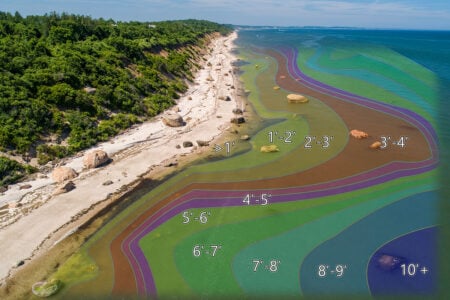
The Bathymetric Data Viewer, or BDV available at maps.ngdc.noaa.gov/viewers/bathymetry can help find uncharted or “under-charted” bottom structure. As the author noted in his first monthly feature on the subject back in February (Ghost of Nuphar), “a BDV side-scan sonar image helped shed light on the identity of a wreck off Townsends Inlet that reemerged from the sand over 125 years after it disappeared.” Next month in The Fisherman the author will turn the Bathymetric Data Viewer on a North Jersey favorite. All bathymetric and chart images are screenshots from the NOAA Bathymetric Data Viewer.
Choosing where to fish off Townsends Inlet during the 1950s and ‘60s wasn’t much of a challenge. We didn’t have a lot of offshore structure to choose from back then. The bottom structure was mostly soft sediment and sand waves.
We had some vertical structure – piers, an inlet wreck, a pound net. But mostly, our fishing choices were which shoals to troll for bluefish, bonito and the occasional tuna, perhaps drift for flounder or jig weakfish. We didn’t know about the wreck of the steamer Nuphar on the inlet outer bar – it was covered with sand (Ghost of Nuphar, February edition).
I’d drift for flounder in the thoroughfares (aka, Intercoastal Waterway) and creeks through the meadows between the island and the mainland, and in the fall, troll in my 14-foot outboard for stripers along the edges of thoroughfare sod banks. Closer to our Sea Isle home, an old, failed concrete bulkhead at the north end of town was a surf fishing kingfish hotspot I could get to on my bike.
Outside the inlet, we drift fished or trolled the Sea Isle City Lump. If it wasn’t too rough, we would run out to the northeast end of Five Fathom Bank when prospecting for bluefish and bonito and along the whole bank when hunting for tuna. The inlet wreck on the Townsends Inlet side of the outer bar and riprap rocks on the Avalon side of the Ocean Drive Bridge were tautog hotspots. Sand fleas dug from the beach were the bait of choice.
We found flounder and sometimes weakfish southeast of the inlet off Avalon around the pound nets. Fishermen from Sea Isle’s Italian community would sometimes make a big haul. One day when I pedaled over to the pound dock to buy bunker, I saw one of their tub-like pound boats filled to the gunnel with fish. I marveled how they somehow made it across the bar and all the way back through Ludlam Thoroughfare to their Sea Isle dock without capsizing or simply losing buoyancy and settling to the bottom!
Bathymetric Data
Far more vertical structure is available today at the State’s artificial reefs, which have greatly expanded bottom habitat increasing the carrying biological capacity. Five of these reefs off Cape May County inlets and the Cape May Canal western entrance provide a huge number of artificial reefs to prospect. There are also two early circular fish havens east of Cape May point. Color-shaded images of sounding data are available for all of these reefs using the National Oceanographic and Atmospheric Administration’s (NOAA) Bathymetric Data Viewer (BDV). The more revealing BDV side-scan-like sonar coverage is available for the two circular reefs. Partial coverage is available for the Cape May Reef, providing an opportunity to compare and contrast the nature of coverage using the two BDV color-shading capabilities.
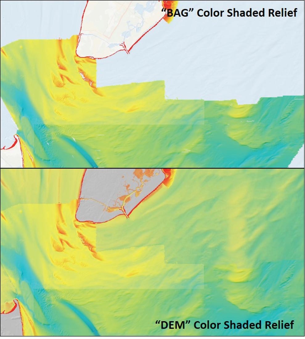
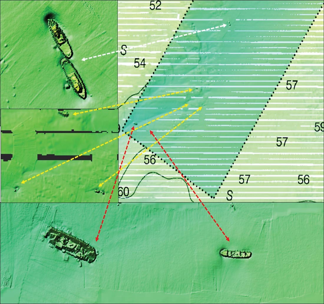
Located on the Atlantic side of the Cape May Peninsula 10 miles southeast of Cold Spring Inlet, this offshore reef should only be attempted in an ocean-capable boat when weather and sea conditions are favorable. A closer alternative is Wildwood Reef, 5 miles east of Hereford Inlet and an 8-1/2-mile run from Cold Spring. The top image in Chart 1 shows the extent of BDV side-scan-like coverage that appears when the BDV “BAG” color shaded relief box is checked. The remainder of the water area shown in blue relief is the Ocean Basemap (Esri, a commercial enterprise that is a leading provider of ArcGIS applications). The bottom image is the display shown when both the BAG and DEM color shaded relief boxes are checked. The DEM display appears to be Esri converted to a 3D-like shaded soundings image.
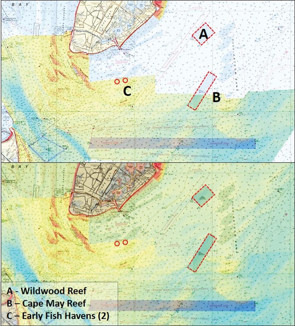
Chart 2 includes the images from Chart 1 overlaid by a translucent NOAA raster navigational chart. The top image shows the extent of BAG image coverage in relation to the fish haven, about the bottom third of the site. The bottom image fills in the uncovered area with the DEM image. My armchair scouting preference is to first use the BAG (top) image since I’m looking for structure. Once I’ve completed that search, I’ll use the DEM (bottom) image to look for additional structure that sometimes presents as mounds, ridges, and holes. For this reason, the DEM color-shaded image is very helpful for scouting New Jersey fish havens that are outside of BAG image coverage.
The DEM image does not include placements after the undetermined date of the image. Nevertheless enables us to identify specific spots with large reef masses that can be correlated with the New Jersey reef program grid drawings.
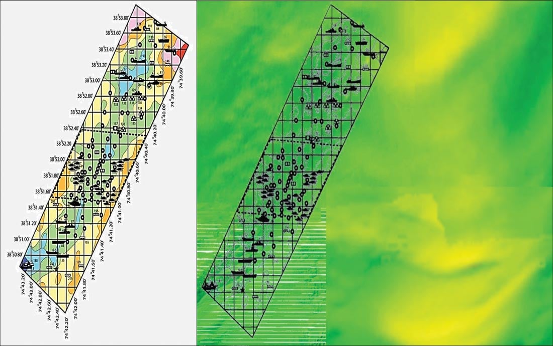
Chart 3 shows how the fish haven and reefs are oriented in relation to the surrounding bottom. The left image is the reef program color grid. The right image shows a grid line drawing with the sounding colors stripped out. The yellowish bottom on the east side of the reef is the southwestern end of Five Fathom Bank. The fish haven lies across a broad east-west depression between high points in the bank. The bottom, especially at the southwestern end of the fish haven, is irregular.
Identifying Structure
Seven of the many vessels donated for this reef are shown in the BAG image. They are barely or not visible when the display is zoomed out, so it’s necessary to zoom in to see what’s there. The date of the BAG image is not specified, complicating correlation with grid data since recent reef deployments occurred after the field survey images were recorded. Chart 4 shows zoomed-in screenshots of all seven vessel reefs. At top left are two vessels configured stern to stern that correlate with the 110-foot long tugs, the Elizabeth and Guido’s Tug. About 600 yards to the northeast is an anomaly, but the image is too grainy to ascertain what it is. However, some Redbird subway cars were deployed in this general area.
The wrecks at middle left correlate, from left to right, as the 56-foot landing craft Peggy Diana, a 250-foot deck barge (and 228 tire units), and the 120-foot trawler Winthrop. The vessel on the left side of the bottom image is the 194-foot ferry Elizabeth; the vessel on the right side is the 106-foot clam dredge Laita. The locations of all these wrecks within the fish haven are shown by arrows. A Guide to Fishing and Diving New Jersey Reefs (www.nj.gov/dep/fgw/artreefguide09.htm) provides geographic coordinates of these and the other donated vessel reefs.
A few scattered small objects are on the bottom just north of these two vessels. Potentially, they could be tire units. Approximate coordinates can also be obtained by placing a browser cursor over an object. The coordinates for this position are shown in the dark grey box at the bottom left of the BDV screen image. The coordinates are coarse, but will get you close.
Tire units, Redbird subway cars, Reef Balls, tanks, concrete castings, and demolition concrete listed on the reef grid detail pages are, for the most part, north and outside of the BAG coverage. Small and low-relief objects typically do not show up on the “DEM” color shaded soundings image. Large wrecks, however, are often portrayed as mounds. As shown in the two Chart 5 left-side images, there are a number of mounds in the northern third of the fish haven. The right image is the bottom left image overlaid by a line drawing of the grid aligned as close as practicable with the fish haven boundary. The overlay demonstrates close correlation with the grid icons.
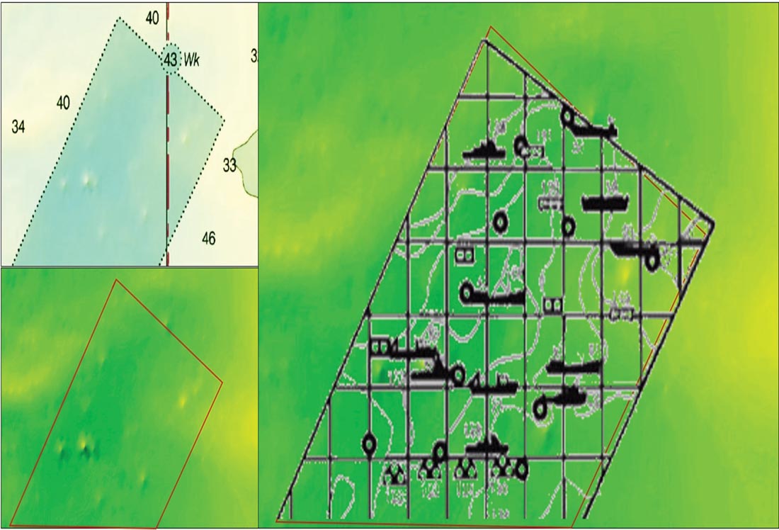
The charted wreck along the north boundary is probably the 205-foot tanker Onandaga that was deployed to the fish haven in 1993. It was probably placed just outside the boundary as a result of error associated with navigational equipment available back then, which also may affect positions recorded in the reef program grid. Found outside the boundary by a field survey team, NOAA charted it as a wreck.
Modern navigational equipment enables use of waypoints to target specific reef structures. Also, major structures listed in the reef guide for all of the state’s ocean reefs have been entered into the Navionics Community Layer. For fishermen using other charting software, the basic information from the Community Layer can be viewed online using the Navionics Chart Viewer application at webapp.navionics.com.
Regardless of the navigation software used, modern technology allows us to scout them from home and when on the water, to get on the reefs without extensive searching, increasing our fishing time.
Wayne Young is a former manager of the Maryland artificial reef program for Chesapeake Bay waters. He is the author of “Chesapeake Bay Fishing Reefs: Voyages of Rediscovery” available on Amazon.com. His Facebook page is Chesapeake Bay Fishing Reefs.