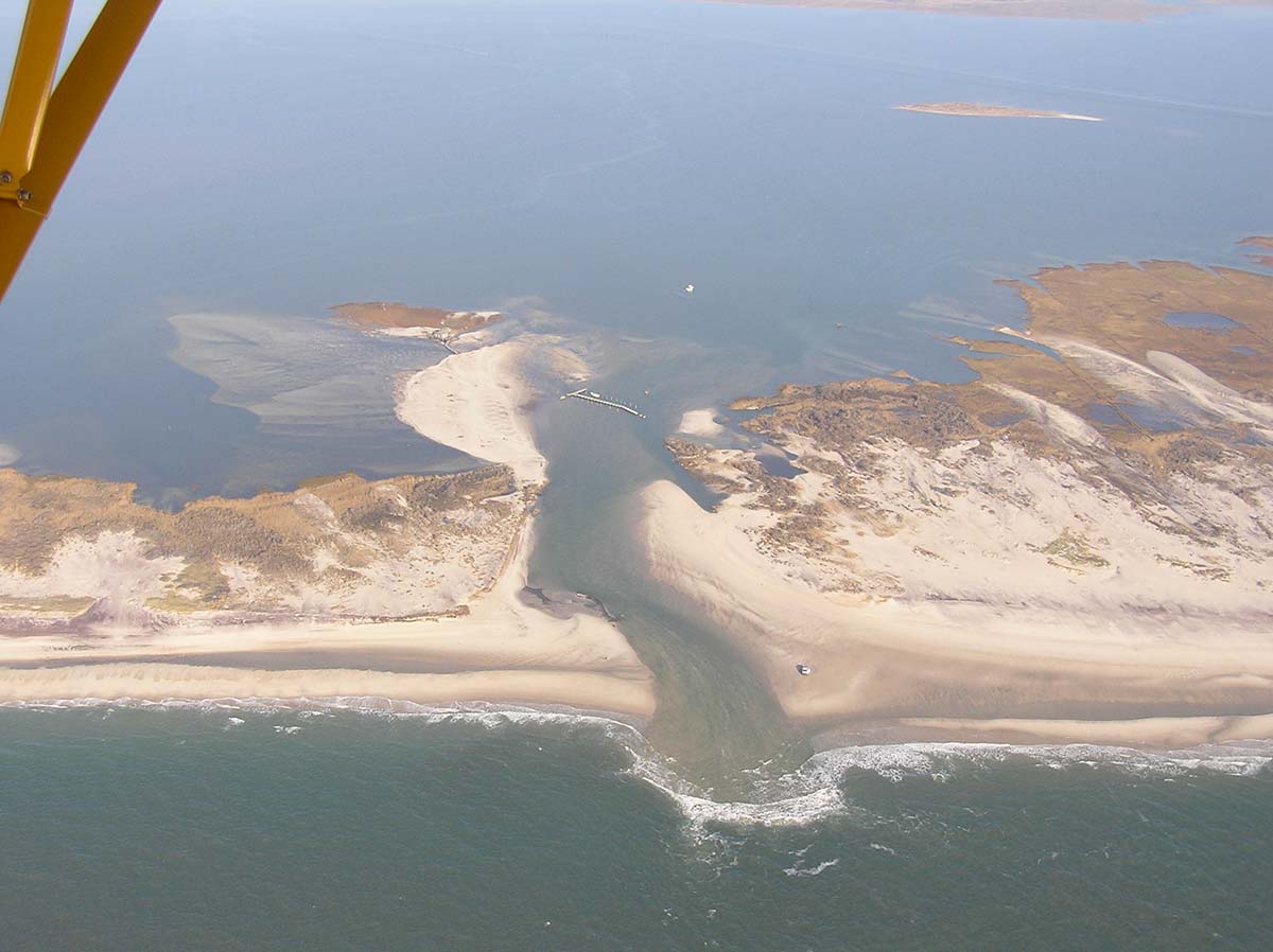
During the end of October in the year 2012, Hurricane Sandy made landfall along the shores of Long Island. The abnormal high tides due to the moon phase in combination with the arrival of the storm devastated the barrier island that protects the mainland along our South Shore. Part of the devastation included the opening of the Old Inlet, afterwards known as the New Inlet about a mile west of the Smith Point pavilion on federal land.
The site of the “breach” was no stranger to opening though. From the 1700s to about 1826, the inlet was used as an entryway for ships delivering goods into the ports of Bellport and Patchogue. That is until two shipwrecks occurred and the inlet was deemed non-navigable according to historical documents and then closed up again until Sandy hit. The low-lying area was always prone to breaching but it took a perfect storm to reopen it.
Initial concerns about the opening immediately worried the local residents who lived on the bay. The concern of course was that, due to the increased water flow into the bay, waterfront properties were more prone to flooding. This of course was proven to be false over the years since the flow had minimal impact on tide levels. Once thing was proven though was the fact that the increased water flow in Bellport and Great South Bays greatly benefited the brown tide problem. After some time of better water flushing, the water quality was very noticeable to anyone who took a trip to this area. With this water quality improvement came better fishing, shellfishing and overall quality of marine life.
There were some campaigns to try and have the breach artificially closed which were shot down since the inlet was on federal land. On the other side of the things, there was also talk about wanting the breach dredged to prevent it from closing on itself which was also denied for the same reason.
The inlet has gone through many changes over the past 10 years. I found myself lucky enough to live close to Smith Point so between a quick drive and 45 minute walk I was at the site of the breach. Over the years I personally observed the inlet go from shallow to deep to wide to narrow to wide at one end and narrow at the other and then sadly, closed. At one point the width of the inlet appeared to be much wider that it’s neighboring inlet, Moriches.

And aside from witnessing the many stages of the inlet, I also fished it for both striped bass and fluke from the shore and a boat. The fishing was spectacular at times. A secret at first, but a little packed in its later years—the inlet consistently produced.
Sadly as I hinted already, the New Inlet closed at the same time of the year, 10 years later pretty much to the day. This past summer it wasn’t looking too good and wading across it was possible at low tide. The last trickles of water went through it during the end of October, signifying the end of an era…for now.
Can this inlet open again? Absolutely, with the right storm coming through. Will it be 150 plus years from now like the last time? Maybe so. For now the site of the New Inlet as we all knew it is once again known as then Old Inlet until Mother Nature decides to do her thing.
To see photo progression of the breach from opening to close over the years, visit po.msrc.sunysb.edu/GSB/.