Scouting a historical “hot spot” using modern day technology.
Notoriously treacherous ocean inlets along the Atlantic Coast collected their share of wrecks. Townsends Inlet is no exception. Some interesting wrecks adorn its entrance. Always unpredictable, the inlet was a great place to learn reading currents and rips and how to handle a small boat in tough conditions! It was also where I learned to respect Mother Nature.
The entrance channel runs out along the north shore of Avalon about a mile. Nowadays, from there it continues southeasterly to the ocean. Back in my youth, the ebbtide bar ringed the inlet from the Townsends Inlet north shoreline on Ludlam Island east for a mile or so, then curved south off the Avalon shoreline. We had to run south along Avalon beach until we found an opening through the ebbtide bar, which could change location or close off almost entirely overnight.
Sometimes, the south entrance would close off, and a slough would open up to the northeast. Rarely, a slough along the Townsend Inlet side would open up, then close off. When open, it was the quickest route to the Townsend Inlet wooden wreck, a tautog haven. We could also sneak in and out on a 13-foot Boston Whaler during fall northwesters when the water nearer shore was flat except for low breakers. Trolling along the beach yielded snapper blues feeding on bunker at the surf line.
Once, the inlet sanded in after we went out in my stepfather’s 30-foot skiff for a day of bluefishing offshore. Approaching the inlet on the way back in, all we could see was a solid wall of 3-foot combers. It was getting late. Thunderheads were building off to the west over the Delaware Bay across the Cape May County peninsula and headed our way. Searching more intently, we found a spot where the swells weren’t breaking. The gap between combers was only 20 feet or so, but its consistency indicated a slight depression in the bar. My stepfather buried the bow in the back of a swell and followed it across. As we went through the narrow opening, our neighbor, another seasoned fisherman, thrust an oar into the water. The top of the blade was above the surface!

Navigating Townsend’s
The inlet channel today is more consistent, influenced by extensive riprap shore protection structures along the Avalon north shoreline all the way to the island’s northeast point, which direct outgoing currents. But, the inlet is still treacherous. A huge volume of water from the meadowland creeks and channels behind the barrier islands discharges between Ludlam Island on the north and Avalon on the south. There is a very deep scour hole with lots of turbulence under the lift span of the Ocean Drive Bridge, which crosses at an angle. This configuration and a shoal immediately east on the north side makes it necessary to zigzag into and out of the span, especially challenging when currents are running strong. Our skiff was low enough to go through a wider side span on the south side. Riprap on the Avalon side of the bridge offers another tautog fishing spot.
East of the bridge approaching the bar, a strong ebb can create standing waves on the inside of the inlet channel. The interaction of strong ebb currents and standing waves with ocean swells can create some really nasty operating conditions. When this occurs, sometimes it’s better to wait it out until conditions moderate.
|
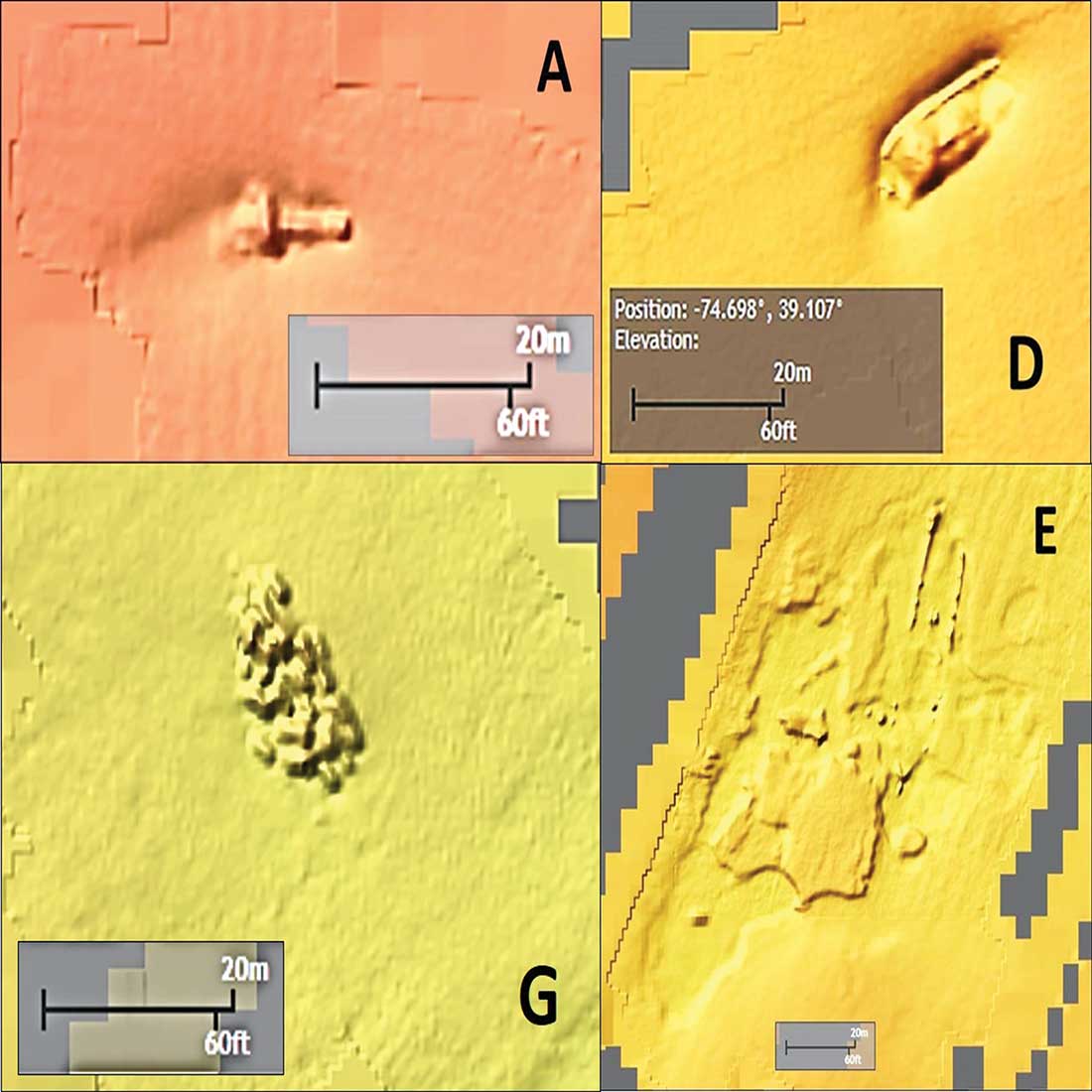
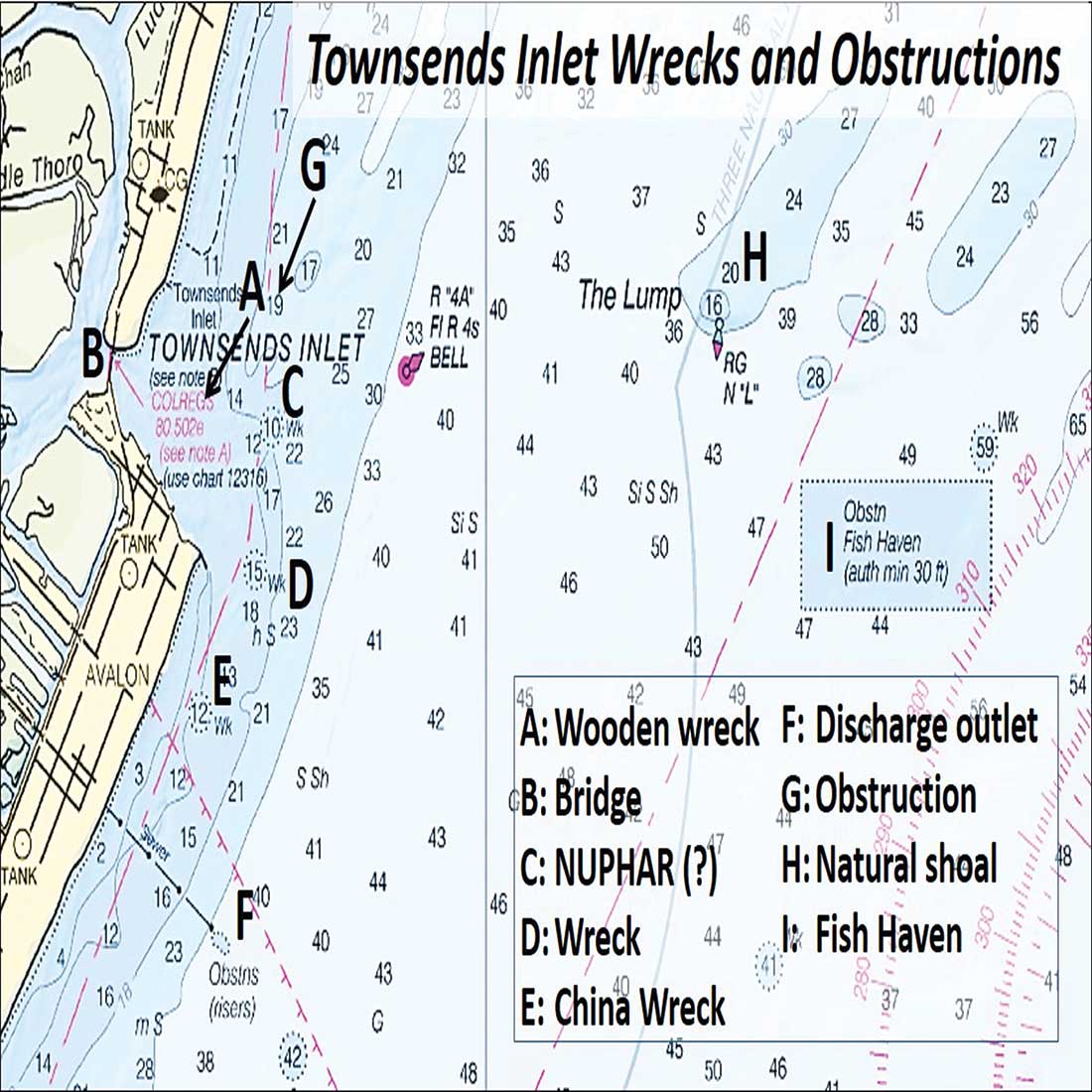
NOAA’s Bathymetric Data Viewer (BDV) shows piece of structure surrounding Townsend Inlet, including (A) a wooden wreck, (C) what could be the wreck of the Nuphar, (D) wreckage that might be the Selina W. Brunnell or St. Jago, and (E) the China Wreck. |
  |
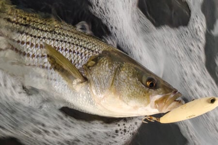
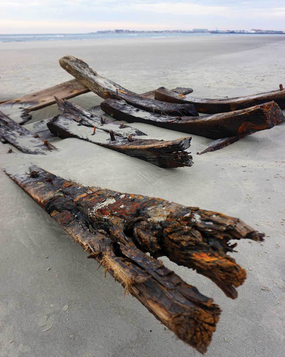
A “go to” fishing hole was the inlet wooden wreck. It was on north side of the ebbtide shoal more or less where the wreck symbol is shown on the inlet chart. Current boils suggested three wreck sections. However, the National Oceanic and Atmospheric Administration (NOAA) Bathymetric Data Viewer (BDV) shows a single object. History records that the British vessel Guatamoozin grounded off Townsends Inlet in 1809 with a cargo of silks and tea. This wreck is shown as closer to shore at about 39 07.12N 74 42.44W by the New Jersey Maritime Museum’s wreck database. Regardless of what vessel met its end, the wreck held tautog. Although the wreckage would sometimes show its location by those current boils on the surface, getting on it back then required lining up chimneys, spires and gables of old shoreline mansions.
Our wreck anchor was an expendable concrete block shackled to an old, rusted 3-foot length of chain bent on an anchor line. We would drop to block into the wreck. If it didn’t come free when it was time to leave, a strong tug on the anchor line would break the block. Sand fleas dug from the beach at a secret spot between Sea Isle City and Townsends Inlet was the bait of choice.
By the Numbers
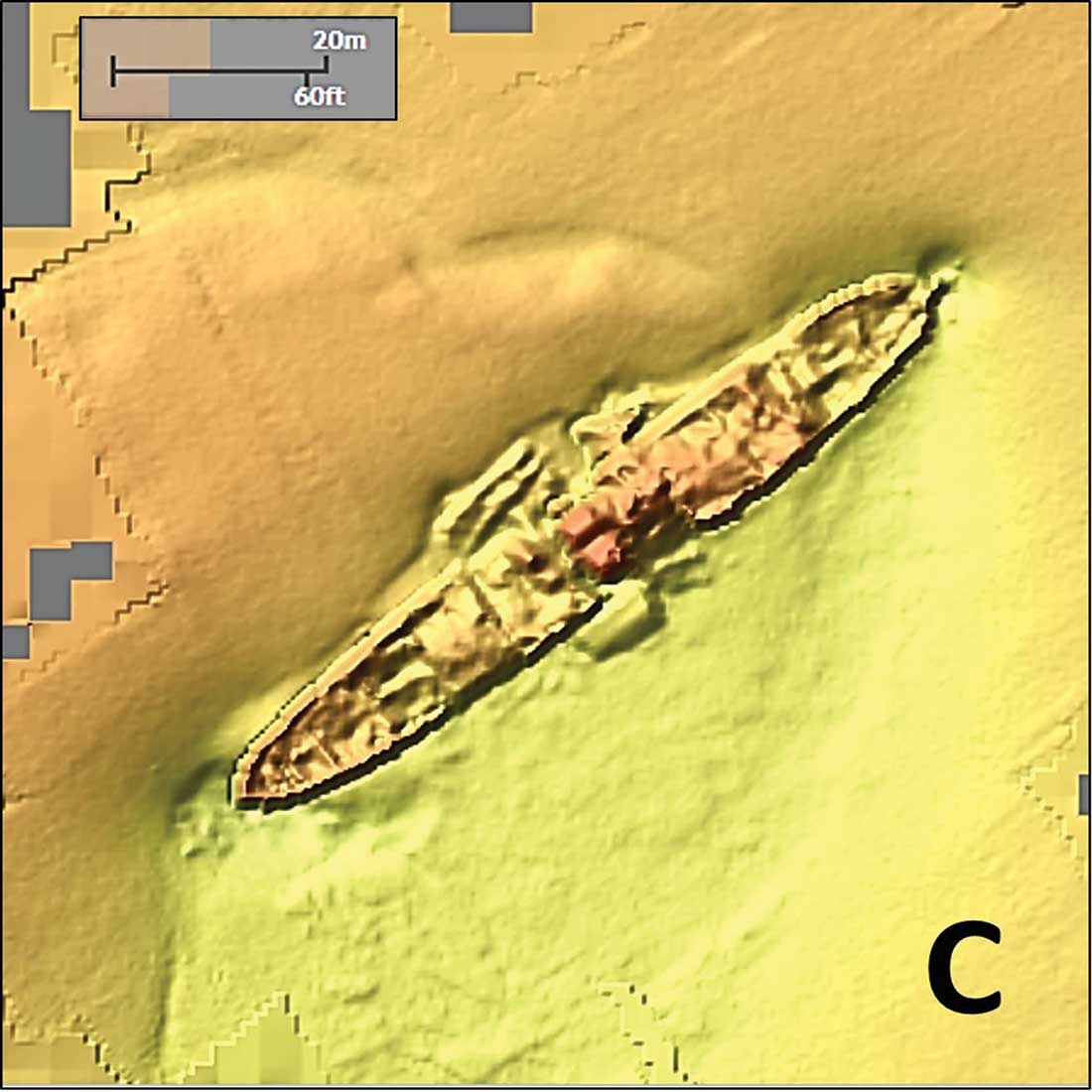
Anticipating a future trip to visit family in the area, I looked for the wreck using the BDV. Looking for other anomalies, what also showed up was a big surprise: a huge shipwreck on the northeast side of the outer bar that we didn’t know about. Located on the north side of the inlet, it is far enough away from the channel as to defy casual detection while passing by. According to the NOAA Coast Survey’s Automated Wreck and Obstruction Information System (AWOIS), the clam fishing vessel Rebecca Snow snagged an obstruction in this vicinity in 1975. She reported it to the Coast Guard as a submerged object where a least depth was 4 to 5 feet.
A government survey in 2002 classified the object as a dangerous sunken wreck with a least depth of 10 feet at Latitude 39 06-54.4N, Longitude 74 41-39.84W. Subsequent side-scan sonar surveys posted in the BDV subsequently captured an image of a large wreck, now charted at 39 06.888N / 74 41.686W. From the image, it has a steamer profile about 270 to 280 feet in length and 30 to 35 feet wide. At the time the sonar image was taken, there was a mound on the outer bar (northwestern) side of the hull and a large scour hole on the ocean side. The wreck lies oriented approximately northeast to southwest on the north side of the inlet about where the outer bar and northeast slough were formerly located. The bow appears to be at the southwest end. The starboard and port gunnels are damaged at the center of the wreck under its superstructure.
The unidentified wreck is so large, how did we miss it? The evidence indicates an old wreck buried under the outer shoal that reappeared like a ghost from the past due to changed physical conditions.
History records that the British vessel Nuphar, a new 287-foot long iron steamer with a 37-foot beam and about 22-foot draft, grounded on the outer bar in late 1882. The crew, assisted by lifesaving station crews, jettisoned cargo of pig iron and drugs to lighten ship, but to no avail. The crew was rescued and assisted with an unsuccessful commercial salvage effort. Then, heavy swells from the southeast broke over the vessel, causing her to break up and sink after about two weeks of pounding.
The wreck was positioned across the channel and considered a dangerous obstruction to vessels using the inlet. She was also yielding many large blackfish and sea bass. By late 1883, she was on the inside of the north outer bar and contributed to the loss of the schooner Selina W. Brunnell. Period fishing reports reveal the aft section had broken off behind the bridge by 1884 and was 8 to 10 feet below the surface. All that was left above water by this time was the ship’s bridge.
Nuphar’s Ghost
The Office of Chief of Engineers awarded a contract in 1891 to Enoch Townsend for removal of the wreck. This work was reported as completed in 1892. Perhaps by the time of the removal contract, the wreck was already heavily sanded in. If so, there may have been little showing to remove, leading to what can now be surmised as an inaccurate completion report. Enoch Townsend must have been smiling all the way to the bank. It’s a bit late for the Corps of Engineers to ask for a refund!
The next encounter was the clammer’s obstruction report. The supposed wreck site coordinates at 39-06-18.41N / 74-40-34.57W were investigated in 2002. Nothing was found, and the wreck was considered “disproved” in the area that was investigated. Diver information on the Internet shows the wreck well south of the inlet entrance off the Avalon shoreline, and report that the wreck was never been found and probably completely covered by sand. No longer. NOAA found and the BDV records a wreck matching the description of the Nuphar about where history says the vessel grounded across the channel on the north outer bar. While this isn’t positive identification, there aren’t any other iron steamship candidates.
But, when did it uncover? During the Ash Wednesday Storm of 1962, there were three tidal surges over two days that covered Ludlam’s Island except for the Townsends Inlet community. Another large discharge through the inlet occurred as a result of Superstorm Sandy. Perhaps the extraordinary discharges from these surges scoured some of the sand that covered the wreck. The “training” of inlet ebb currents by the shoreline protection structures also contributed to shifting current patterns. The net result – the outlet channel runs along the Avalon shoreline towards the east southeast and the outer bar has moved about a half mile closer to the Ludlam Island shoreline. This in turn would have exposed the wreck site to physical energy from large ocean swells. The net effect of changed conditions is a scour hole under and south of the wreck site in which the uncovered wreckage sits. Regardless of why it’s showing now, the wreck is there waiting for fishermen to drop a hook. Blackfish, sea bass, and sheepshead found the wreck quickly before, and now that she’s showing, should be liking it again!
There are two other wrecks nearby. What appears to be about a 50-foot long vessel with what appears to be a pile of sand on top of what might be a cabin or pilothouse. The wreck is unidentified. Perhaps it’s the 1883 wreck of the Selina W. Brunnell or the 1868 wreck of the schooner St. Jago, which also sank in this general area, perhaps not. Just south of this wreck is the well-known China Wreck, also called the China Junk Wreck. The BDV image shows a faint image of the bulwarks along with widely scattered wreckage. Rather than a Chinese junk, it’s the remains of a wooden vessel with a cargo from China. Some reports say the vessel is an unidentified late 19th century wreck with a cargo of China plates, some of which were recovered by recreational divers. Regardless, the wreck gets its name from the cargo it carried. There is also a report that this wreck was blown up in 1942 as a danger to navigation. If so, that could account for the widely dispersed wreckage.
South of the China Wreck look for a sewer outfall where the BDV shows a long line of objects offshore. The configuration suggests an effluent diffuser outfall. Another interesting obstruction on the Townsends Inlet Wrecks and Obstructions chart at location “G” appears to be a “patch” reef of concrete rubble or pipe. A bit father offshore is The Lump; marked by a nun buoy, this natural shoal was one of our go to bluefishing and bottom fishing spots, as it is today.
Wayne Young is a former manager of the Maryland artificial reef program for Chesapeake Bay waters. He is the author of Bridges Under Troubled Waters: Upper Chesapeake and Tidal Potomac Fishing Reefs, available on Amazon.com. His Facebook page is Chesapeake Bay Fishing Reefs.