What’s in a name? Some historic fishing locations on the Delaware!
Whether you’re new to the area, or new to sportfishing, reading fishing reports can sometimes be frustrating; and asking where the hotspots are marks the inquirer as a fishing newcomer, an area greenhorn, or a hotspot grabber. As a service to readers, here’s a little crib sheet to assist in correlating fishing reports with hot spots on Delaware Bay.
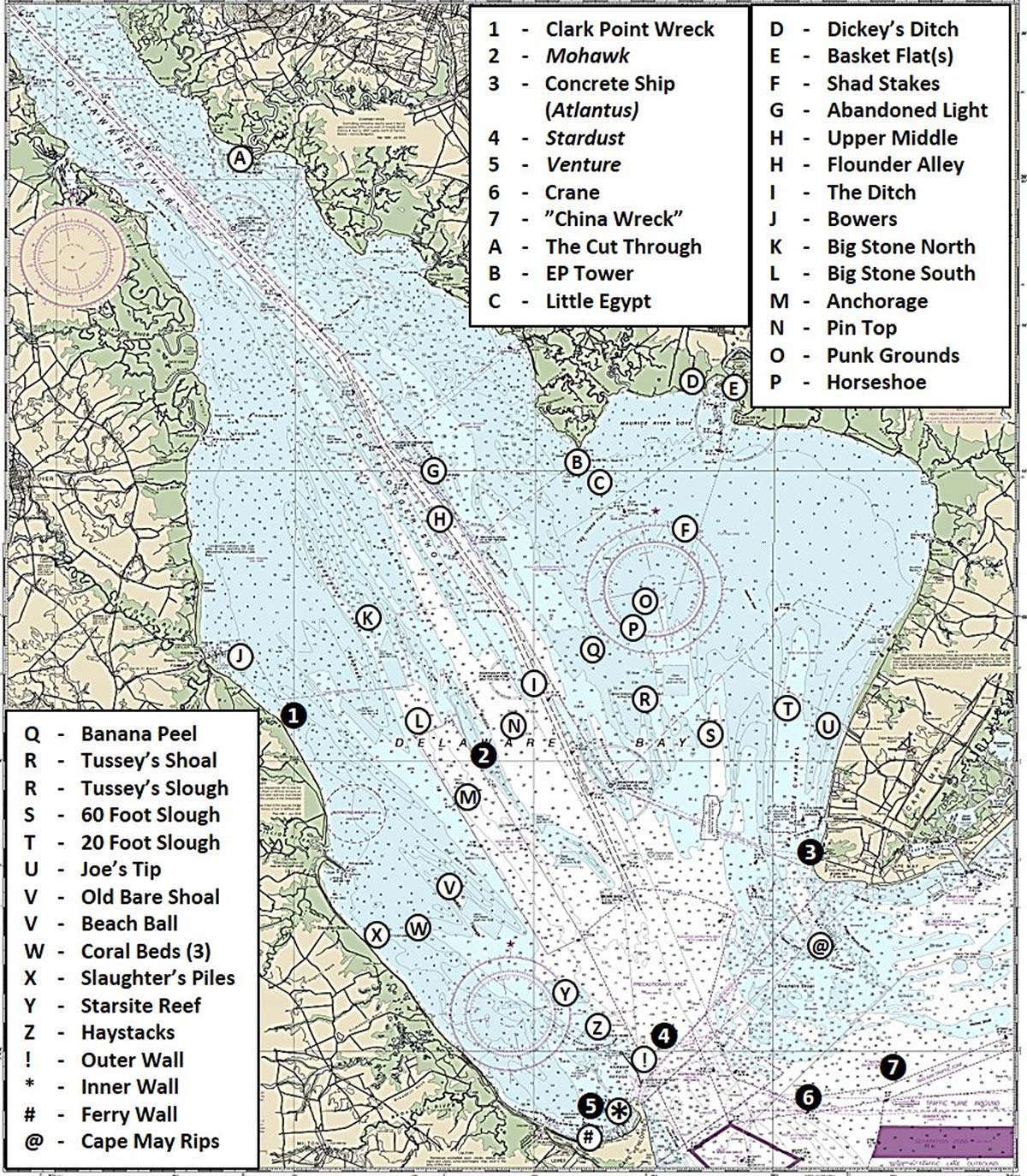
Place names, description, and geographic locations presented in Chart 1 took advantage of research results from our BDV Spotlight series. There are other place names, some obscure, and some which are not fit for print; but this should provide a good head-start in building local knowledge of Delaware Bay locations.
Various old names may be encountered when digging through historic charts and reports to help identify old structural features, as early names have changed over the years. For example, a very early chart lists Cross Ledge as Crof’s Ledge. Who Crof was and why the ledge was named after him are lost to history. Old names are sometimes, corrupted through mispronunciation, dialects, or misheard and passed on to others. So, Crof became Cross.
In another example, several old charts list Delaware’s Murderkill River as Mother Kill Creek. The U.S Department of the Interior’s Geological Survey Bulletin 1245 Delaware Place Names (1966) records that “The earliest form of the name appeared on Lindstrom’s maps as Mordare Kijhlen, Swedish for “the Murderer’s Creek””. Although the actual name derivation isn’t known, it’s easy to envision how the old Swedish name became a corrupted translation in the English language.
The middle of the Delaware Bay is a muddle when it comes to place names. Some older geologically oriented feature names changed over time to those of individuals or alternative descriptions. For example, the underwater ridges that we know as Joe Flogger Shoal, The Lower Middle, and Hawknest were “Shears Outer Fork,” “Shears Inner Fork,” and “Long Western Flat” respectively. The Shears just north of the Harbor of Refuge was “Part of the Shears.” The term “shear” was an inexact use of a geological term to identify the now submerged underwater ridgelines that separated tributaries and feeder creeks.
What is now charted as the Elbow of Cross Ledge Range and Miah Maull Range was earlier known as the “Upper Middle”. The lower end was marked by the Upper Middle Light Boat. When it was replaced by Cross Ledge Light, a buoy was established across from the Elbow of Cross Ledge and charted as “the buoy of the middle”. A few early charts also applied the term as an alternate name for Cross Ledge. “The Lower Middle” was used to denote the lower half of the middle of the Bay, and is now applied to the shoal which is the lower half of the Shears Inner Fork.
Although where some of the names came from and who named them may be obscure to unknown, what’s important to recreational fishermen is the linkage of the names to the geographical locations to fishing hotspots.
20-Foot Slough (North end of Bayshore Channel / Site T). This natural feature is off the west side of Cape May County. Look for Black Drum to forage in this slough.
60-Foot Slough (Site S). The remaining deep-water section of the geologic Maurice River bed southeast of New Jersey’s Delaware Bay Fish Haven.
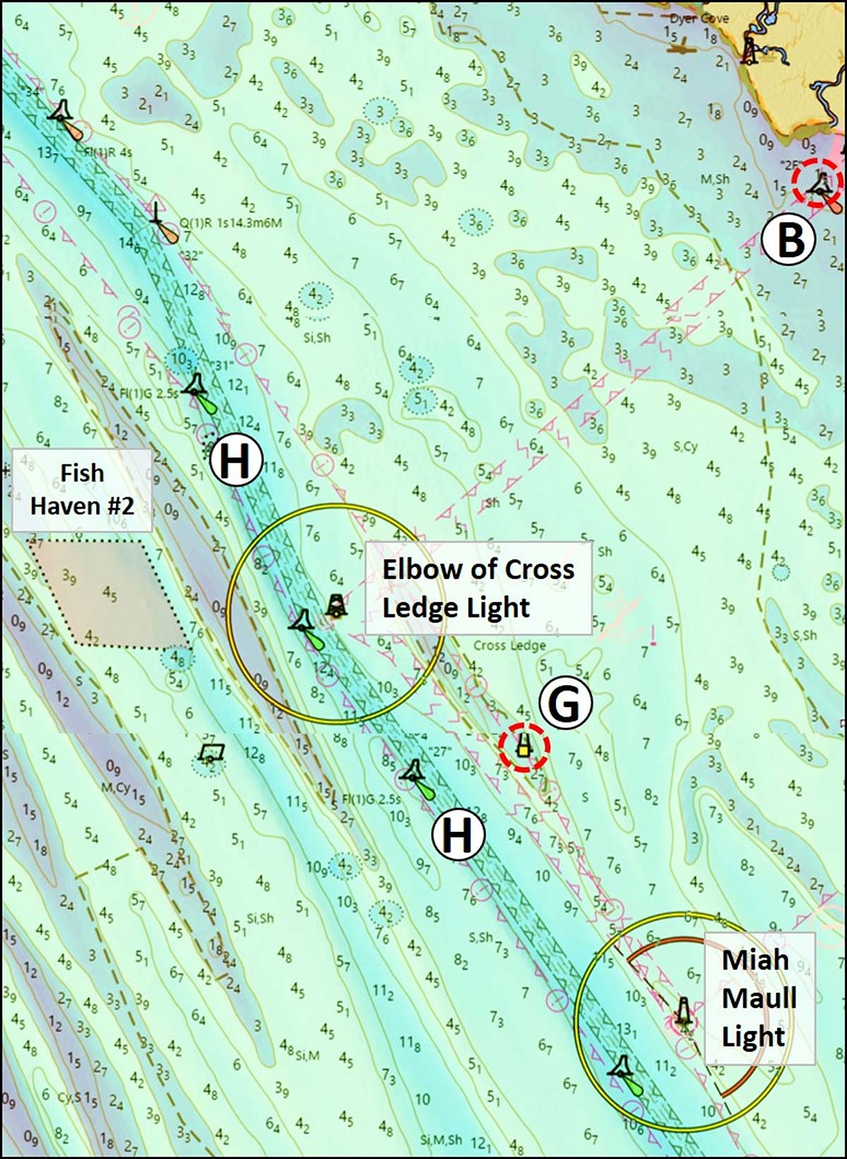
Abandoned Light (Site G, Chart 2). Foundation pier and platform ruins of the former Cross Ledge Lighthouse. Watch out for (and cast to) large riprap protective rocks around the base which uncover at very low water.
Anchorage (Site M). A charted and buoyed tanker anchorage. It’s on the southwest side of the ship channel in the deep-water geologic Southern Valley just southwest of Delaware Fish Havens #6 and #7.
Banana Peel Slough (Site Q). A narrow slough across the ship channel northeast of Fourteen Foot Bank around coordinates 39° 04.036N / 75° 07.501W.
Basket Flat(s) (Site E). A former peninsula that was eroded away just inside the entrance to the Maurice River north of East Point. The southeast end was protected by two steel barges filled with rocks. Both are still there and awash forming an unofficial artificial reef.
Beach Ball (Site V). A hotspot located at the northwest end of Broadkill Slough northwest of Delaware Fish Haven #5.
Big Stone North (Site K). Black Drum fishing grounds off of Big Stone Beach, DE northwest of Delaware Fish Haven #3 and west of Hawknest Shoal.
Big Stone South (Site L). Black Drum fishing grounds off of Big Stone Beach, southeast of Delaware Fish Haven #3 at the extreme lower tip of Hawknest Shoal.
Bowers (Site J). Entrance to and off the southern jetty of Murderkill River inlet. It takes its name from Bowers Beach, DE.
Cape May Rips (Site @). Disturbed water over shoals southeast to southwest of Cape May Point in the northern two thirds of the Delaware Bay Entrance. Historic striped bass location, though it’s been a few years.
China Wreck (Site 7, Chart 3). This is a 32-foot least depth wreck that had chinaware in its cargo that is located outside the Bay Entrance north of the traffic lanes at coordinates 38° 49.239N / 74° 54.973W. It’s thought to be the British cargo vessel D. H. Bills.
Clark Point Wreck (Site 1). An unidentified wreck that was marked by a buoy (since disestablished) in 1948. It was awash at half-tide in coordinates 39° 01.507N / 75° 19.934W, but is now below the surface.
Concrete Ship (Site 3). The Atlantus was a World War One concrete cargo ship that was sunk in 1926 as a breakwater just south of the entrance to the Cape May Canal at coordinates 38° 56.651N /74° 58.338W. What’s left today are broken up large concrete chunks, one of which breaks the surface. The remainder are in an elongated pile more or less perpendicular to the beach.
Coral Beds (Site W). Natural colonies of tube worms rather than corals. Found at multiple locations, including two prominent spots off of Slaughter Beach, Delaware, between Slaughter’s Piles and Delaware Fish Haven #3.
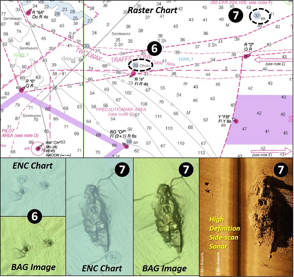
Crane (Site 6, Chart 3). A crane that was lost off a barge at coordinates 38° 48.009N /74° 58.809W. The feature is recorded as an obstruction with File Number 8977 in the Coast Survey’s Automated Wreck and Obstruction Information System (AWOIS). The wreck site was investigated by divers during a 1993 hydrographic survey. According to AWOIS, “Divers describe metal structure resembling a crane in Boom lies ENE x WSW and extends 1.8 meters off bottom West end tapers into the sand toward the east.”
Dickey’s Ditch (Site D). Creek with entrance on the west side of Elder Point along the north shore of Maurice River Cove.
EP Tower (Site B, Chart 2). Egg Island Point Light on the west side of Maurice River Cove at coordinates 39 10.333N / 75 07.885W, about 1,400 yards south southeast of the point. About 800 yards northwest is the charted wreck of the oyster boat Darlene. It sank after striking a stone pile, an 8-foot obstruction which marks the remnants of a long-submerged breakwater that had protected the former Egg Island Lighthouse. Foundation ruins of the lighthouse are charted as a 1-foot obstruction south southwest of the point.
Ferry Wall (Site #). Long breakwater extending northerly from Lewes which provides a protected harbor for the Cape May-Lewes Ferry.
Flounder Alley (Site H, Chart 2). The ship channel north and south of Miah Maull Shoal spanning the Elbow of Cross Ledge and Miah Maull charted ranges.
Haystacks (Harbor of Refuge Icebreakers) (Site Z). Eleven stacked stone piers (including marker piles at each end) northwest of the west end of the Harbor of Refuge. Four additional stacked rock piers that were in aligned with the breakwater in the gap between it and the northeastern-most icebreaker were removed to clear the ferry route. Some scattered rocks from three of these former icebreakers remain on the bottom.
Horseshoe (Site P). Refers to an area on the west side of the upper 60-foot slough just east of a long underwater finger that extends down from Egg Island Flats around approximate coordinates 39° 04.665N / 75° 05.865W.
Joe’s Tip (Site U). The north end of the narrow northeastern slough off the Bay Shore Channel around coordinates 39° 04.410N / 74° 55.799W. Look for black drum working their way through this slough in the spring.
Little Egypt (Site C). The edge of a low profile broad mound that is about 2,000 yards southeast of the Egg Island Point Light (“EP Tower”) around coordinates 39° 09.796N, 75° 06.801W.
Mohawk (Site 2). This is the demolished wreck of the large passenger ship Mohawk (AWOIS #11941) that sits on top of The Lower Middle. It’s just below the surface and immediately northwest of Buoy RN “LMW” at coordinates 39° 00.147N, 75° 12.316W.
Old Bare Shoal (Site V). Charted name of a narrow submerged ridge line east to southeast of the Mispillion River along the eastern side of Broadkill Shoal. The Beach Ball is off to the southwest.
Pin Top (pintop) (Site N). A small shoal with a sharp bump southeast of Buoy R “16” at coordinates 39° 1.449N / 75° 10.690W.
Punk Grounds (Site O). North end of a broad slough north northwest of New Jersey’s Delaware Bay Fish Haven around coordinates 39 05.004N / 75 05.165W.
Shad Stakes (Site F). An area about halfway between the Maurice River entrance buoy and the north side of the New Jersey Delaware Bay Fish Haven around coordinates 39° 07.833N / 75° 03.347W.
Slaughter’s Piles (Site X). A charted cluster of piles off of Slaughter Beach.
Stardust (Site 4). This is a 104-foot least depth wreck of the Fishing Vessel Stardust. It sits upright and intact on the bottom.
Starsite Reef (Site Y). This is the commonly referred to name for Delaware State Fish Haven #8.
The Cut Through (Site A). Breach in the former peninsula at the entrance to the Cohansey River that now serves as the access channel.
The Ditch (Site I). Alternate name for the portion of Flounder Alley below Miah Maul Shoal, beginning about Buoy R “16”.
The Inner Wall (Site *). The Delaware Breakwater inside Cape Henlopen and southwest of the Harbor of Refuge breakwater.
The Outer Wall (The Wall) (Site !). The Harbor of Refuge breakwater.
Tussey’s Shoal (Site R). A shoal immediately southwest of the southwest corner of the New Jersey’s Delaware Bay Reef at coordinates 39 02.157N / 75 04.797W.
Tussey’s Slough (Site R). North end of the slough on the west side of Tussey’s Shoal.
Upper Middle (Site H). Old name for the Elbow of Cross Creek Range and Miah Maull Range. The Upper Middle Lightship (“Light Boat” on 1848 chart) marked the southern end of this reach until 1875 when it was replaced by the Cross Ledge Light. After that, a buoy was established on the west side of the ship channel about halfway between Elbow of Cross Ledge and Miah Maull Shoal and named “The Buoy of the Middle”.
Venture (Site 5). Scattered wreck of the Fishing Vessel Venture off the northwest end of Delaware Breakwater at coordinates 38 48.173N, 75 07.3244W.
Find the National Oceanic and Atmospheric Administration’s Bathymetric Data Viewer at www.ncei.noaa.gov/maps/bathymetry or simply by Googling “NOAA Bathymetric Data Viewer.”