The other day, while perusing the colorful landscape that is my Facebook feed, I came across a post that I thought Fisherman readers would find interesting. On a page called “LiDAR and Aerial Technology,” there was a scan of Dutch Island. I think New England anglers might be surprised by how much history hides in the scrub and beach rose that lines our shores and after exchanging messages with the page owner I obtained his permission to share the images and his write-up…
“The earthworks of Dutch Island in Narragansett Bay and were constructed between 1897 and 1908 as part of the Endicott-era coastal defense system, protecting Newport Harbor. Named for First Lieutenant John Trout Greble, the first West Point graduate killed during the Civil War, the earthworks housed disappearing guns, rapid-fire artillery, magazines, barracks, and supporting military infrastructure designed to defend Rhode Island’s strategic waterways.
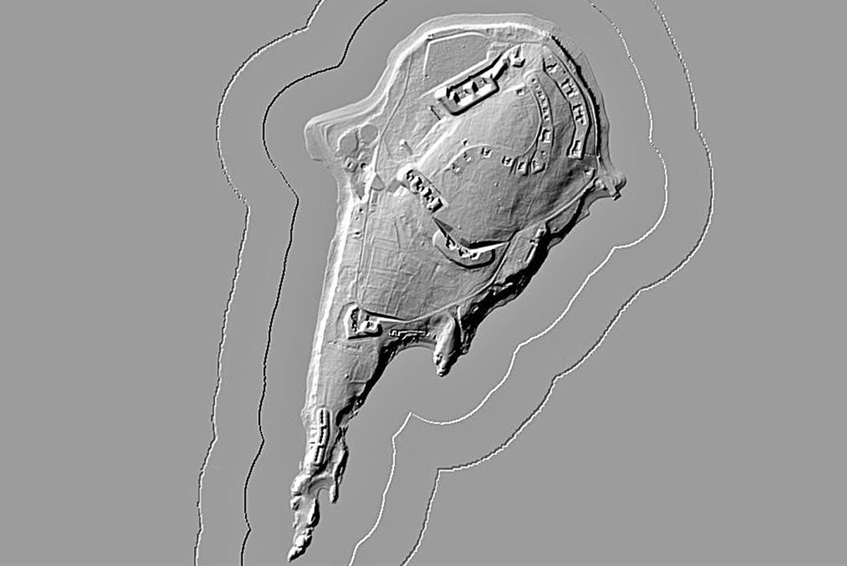
LiDAR reveals the remarkably preserved layout of the fort, including gun batteries, roads, earthworks, and building foundations that remain visible across the island more than a century after the fort’s construction. The imagery highlights how extensive the installation once was and how much of its footprint survives, despite decades of abandonment.
Dutch Island itself has a much longer military history… during the American Revolution, British forces occupied the island as part of their control of Newport and Narragansett Bay. By the late 19th century, the same strategic location was selected for a new generation of coastal defenses as the United States prepared to protect its harbors from modern naval threats.
Today, Fort Greble stands as one of the best-preserved coastal defense sites in Narragansett Bay, with LiDAR providing a unique view of a military landscape that is often difficult to appreciate from the ground.”
For those unfamiliar with LiDAR technology, NOAA states that the acronym stands for Light Detection and Ranging, and it is a remote sensing method that uses pulsed lasers from airplanes or helicopters to generate precise, three-dimensional information about the Earth’s surface. NOAA scientists utilize this accurate technology to produce shoreline maps, create digital elevation models, and assist in emergency response operations.
And for those who would like to know more about the fishing that can be found at Dutch Island, check out the Hotspot Article I wrote about it a few years back.