A hotbed of summer striper action, this spot is more than just bass country.
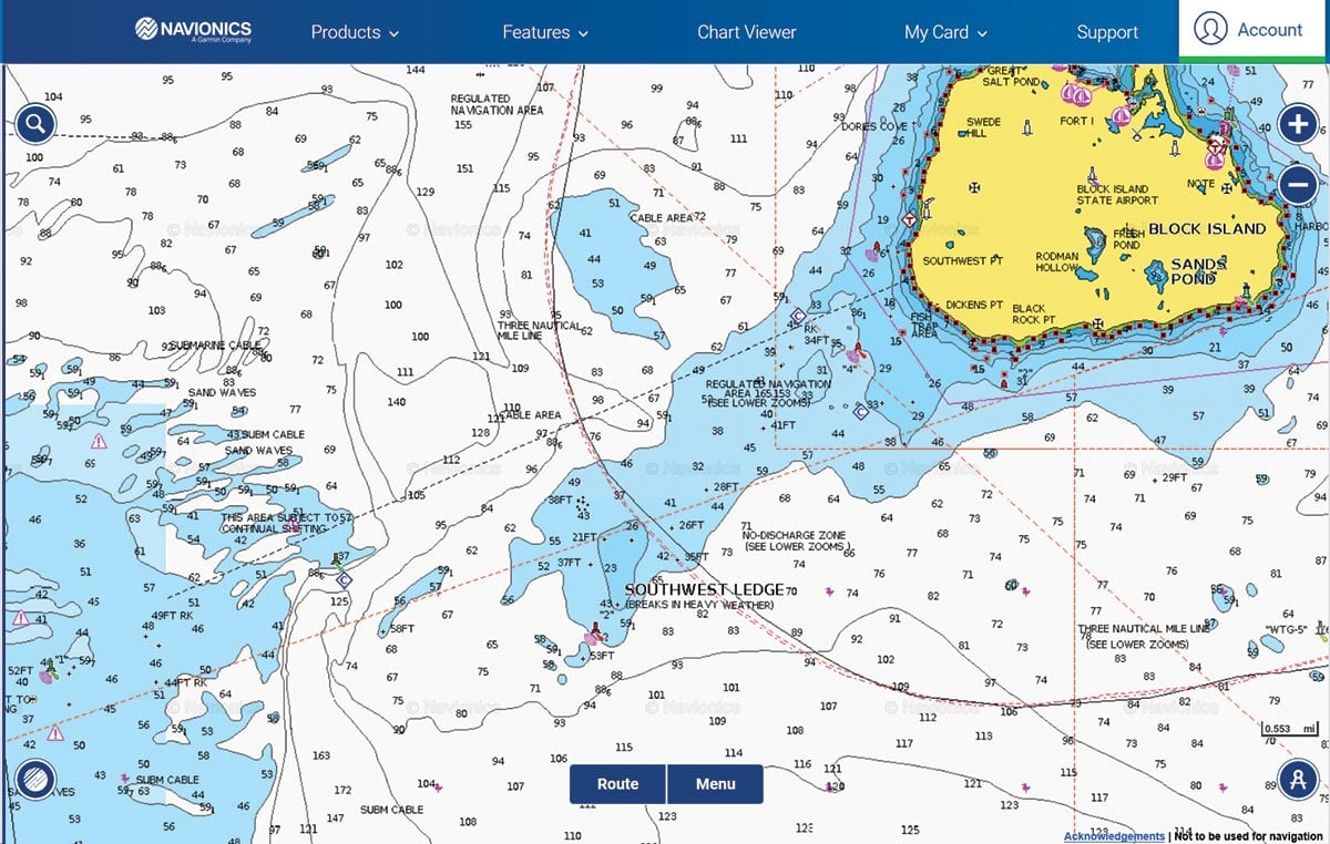
Without a doubt, Southwest Ledge has become one of the premier locations to catch striped bass on the East Coast, if not the planet. We are very fortunate to have it in our neck of the woods. It seems like year after year a tremendous number of stripers, some well over 50 pounds, are caught here either by boats trolling or fishing eels. While it’s a fairly large area, on any given weekend day in the summer you can literally count a hundred or more boats fishing here, both charter and private, from RI, CT, NY, and even MA.
The ledge itself is located just off the southwest corner of Block Island. The bottom is a mix but contains many rocks and boulders. The three main things to watch out for while fishing here are 1) rough weather, 2) lobster pots being pulled under with the tide, and 3) the three mile limit for Federal/State waters (EEZ). The ledge is a shallow area facing out into the open ocean so when you get heavy wind or seas they can begin to break on the ledge – making it a nasty place to be. Lobster pots pulled under with the tide can cause havoc with your lines and potentially your prop. Because it’s illegal to fish for or possess stripers in Federal waters you need to pay attention to the three mile line so that you don’t go over it. Good charts or chartplotters will display the limit line for you so that you can make sure that you stay inside of it. There’s a lot of good bass territory just inside this line.
The ebb tide runs to the SE and the flood tide runs to the NW. Look for the ebb to begin about 20 minutes before the Race and the flood to begin simultaneously with the Race. I prefer to fish it on the flood tide, but the ebb can also be productive. We’ve caught our share of stripers while fishing just inside the 3-mile line around 41-06-58.2/71-39-08.3 and around 41-07-15.7/71-39-33.3.
“The Peanut” is a popular rocky section on the ledge and gets its nickname from the shape it forms on some charts. I say “some” charts because it’s obvious to you if your chart shows it that way. For those whose charts show it more like a boulder they keep scratching their head and asking where it is. For reference, it’s located at 41-07-34.1/71-38-52.4 and tends to hold a good number of striped bass at times.
“The Drop” is located to the northeast around 41-08-01.8/71-39-35.3. This spot drops from 45 feet to a 90-foot-plus deep sandy pocket. On several occasions we have found some rather large stripers sitting here ambushing bait being pushed across the ledge on a flooding tide. These fish were susceptible to eels fished near the bottom but keep an eye out for dogfish. You’ll need some considerable weight (5 to 8 ounces) to keep your baits down near the bottom here, and because the current can be stiff the key is to begin well up-tide and drift back through. Since you’re dropping off an edge into deeper water you’ll need to continually check the amount of line out to stay with the bottom. We’ve also caught our share of fish drifting eels through the boulder field around 41-07-59/71-38-47.
You can find black sea bass on most of the boulders, especially out on the main part of the ledge by the buoy. There’s a rock pile located at 41-07-17.3/71-39-53.9. Keep your sounder on and you will inevitably run over some rocks to stop on and prospect. The high spots of the ledge just outside the 3 mile line also can produce decent sea bass. From December to April you may even find a codfish or two around 41-07-22.1/71-39-29.1. In addition we’ve caught blackfish around 41-05-50.9/71-40-25.4 in the fall so don’t overlook its rocky terrain.


