This month’s BDV Spotlight looks at one of our local Mohawk wrecks!
Are there drums along the Mohawk? Walter D. Edmond’s historical tale about trials and tribulations of living on the early upstate New York frontier along the Mohawk River was one of my favorite grade school reads. So, not one to pass up an opportunity for a play on words, the book inspired the title for this write-up about the wreck of the Revenue Cutter (USRC) Mohawk.
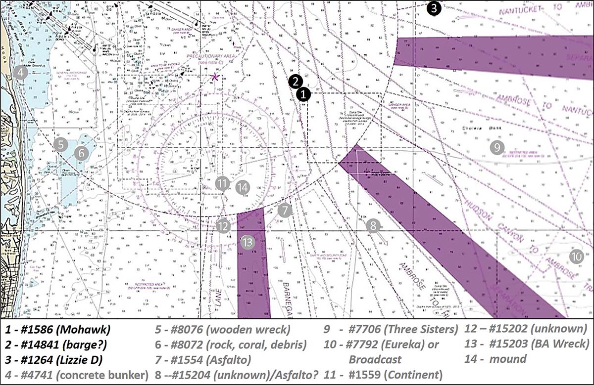
The remains lie in deep water 400 yards west of the northwest corner of the 12-Mile Dump Site on the northeastern slope of the Hudson Canyon, also referred to as “Wreck Valley” (see Chart 1). That said, the New York Bight is within the northern range of both the black and red drum species; some are caught in coastal waters each year, although Delaware Bay waters offer better opportunities for finding and catching these species; more likely, recreational fishermen will find tautog and sea bass hanging out at the wreck site.
The Revenue Cutter Service under which Mohawk served, along with the U.S. Lifesaving Service, Steamboat Service, and Lighthouse Service, were folded into the U.S. Coast Guard. Today, the 270-foot USCGC Mohawk (WMEC 613) based in Key West, FL is carrying on the search and rescue and security tradition of her two cutter namesakes which bore this name. With family ties to the Lifesaving Service and Coast Guard plus over three decades of Coast Guard active duty and civilian service, a Revenue Cutter wreck is like a magnet to this old sailor!
If that weren’t enough, one dark night back in the early 1970s while on an anti-drug smuggling operation, my patrol boat was almost run over by a Navy transport due to piloting error by the officer of the deck. The fate of the Mohawk strikes close to home, plus it’s a good example for illustrating on-line resources available for armchair scouting of ocean wrecks.

Exploring Wrecks Online
A comprehensive list of shipwrecks with vessel type, dimensions, location, and other basic information is maintained by the New Jersey Maritime Museum. The list is accessible at njmaritimemuseum.org/shipwreck-database. For actual on-site conditions, a detailed discussion with pictures and side-scan sonar images is found on Rich Galiano’s njscuba.net website. Another great diver website with extensive wreck data is aquaexplorers.com. For wreck histories and high-definition scans, check Ben Roberts’ Eastern Search & Survey (ESS) Google wreck map which can be accessed via a browser search. I can’t say enough about the value of these and other wreck and diver websites to informing recreational fishermen about fishing conditions they may encounter. The websites contain detailed information about bottom structure at wreck dive sites and artificial reefs that is not otherwise available to sportfishermen.
A very helpful government web resource is the Bathymetric Data Viewer (BDV) web application maintained by the National Centers for Environmental Information (NCEI), a component agency of the National Oceanic and Atmospheric Administration (NOAA). Descriptive Reports (DR) prepared by or for the National Ocean Service (NOS), another NOAA component, are accessible using the BDV.
NOS DRs are a particularly valuable resource. They document the results of field surveys made for the purpose of updating nautical charts. Survey parties are also often tasked to check out specific reported wrecks and obstructions as well as report uncharted wrecks and obstructions discovered during field work. Over the past dozen years or so, reports have included a selection of side-scan sonar and alternative imaging of multi-bean sonar data that enables an improved understanding of the features that were investigated.
DR details were a primary source for field report information that appears in call-up boxes embedded in the Coast Survey’s Automated Wreck and Obstruction Information System (AWOIS). Although AWOIS is no longer updated, it remains a valuable, easy-access resource for scouting wrecks and obstructions. Using AWOIS data call-up boxes is a whole lot easier to use than working through detailed technical reports to find nuggets of information, although the DRs are more complete.
Offshore Mohawk History
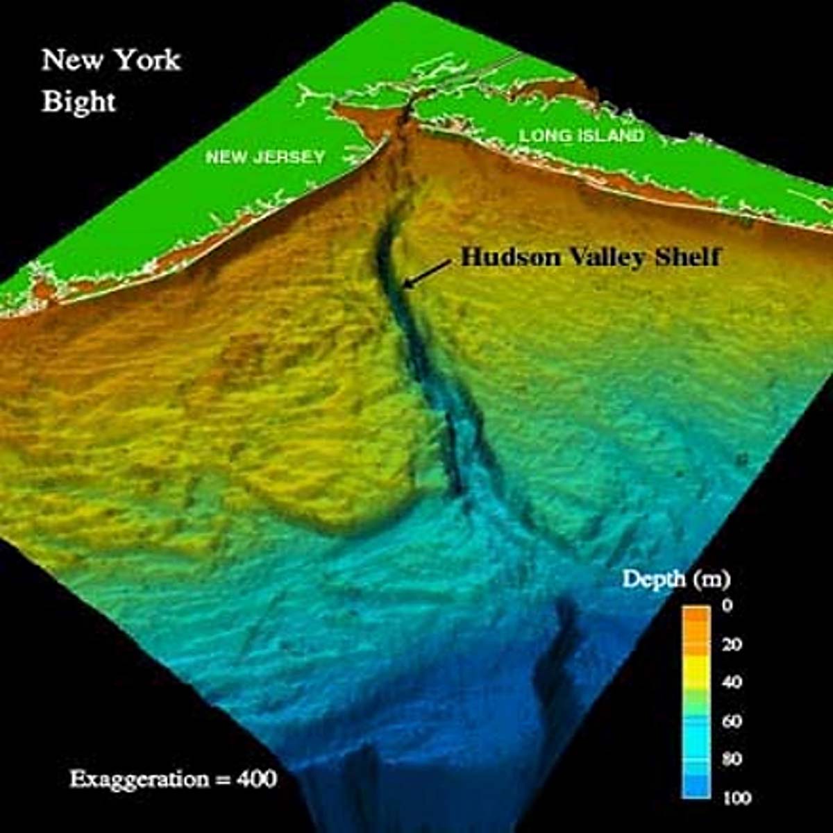
What may look like unpromising as fishing structure when using BDV “BAG” Color Shaded Relief images is actually just the opposite when compared with images in the NOS DRs which have additional detail. Some DRs also selectively feature interesting structure with intriguing images. Such is the case for a number of wrecks and obstructions in and around the New York Bight. A sample selection of structure for which revealing images are discussed in this narrative are shown on Chart 1 in black. The deep ravine which runs through the Bight, the Hudson Canyon, is known as Wreck Valley for good reason (see Chart 2). Now, the rest of the Mohawk story.
USRC Mohawk was built in 1904. Dimensions were 200 feet long with a breadth of 32 feet. The ship carried a complement of 77 officers and crew. It primarily conducted safety patrols and search and rescue. The cutter was temporarily transferred to the U.S. Navy with its Revenue Cutter Service crew in 1917 for service during the First World War. On the night of October 1 of that year, the cutter was struck amidships in a collision with the British tanker SS Vennacher. Damage was too severe for effective damage control. The cutter sank where it now lies roughly 10 miles south of Jones Beach on Long Island and 12.5 miles east of Sandy Hook at the Jersey Shore. Too badly damaged to salvage, the wreck provides habitat and sportfishing opportunity.
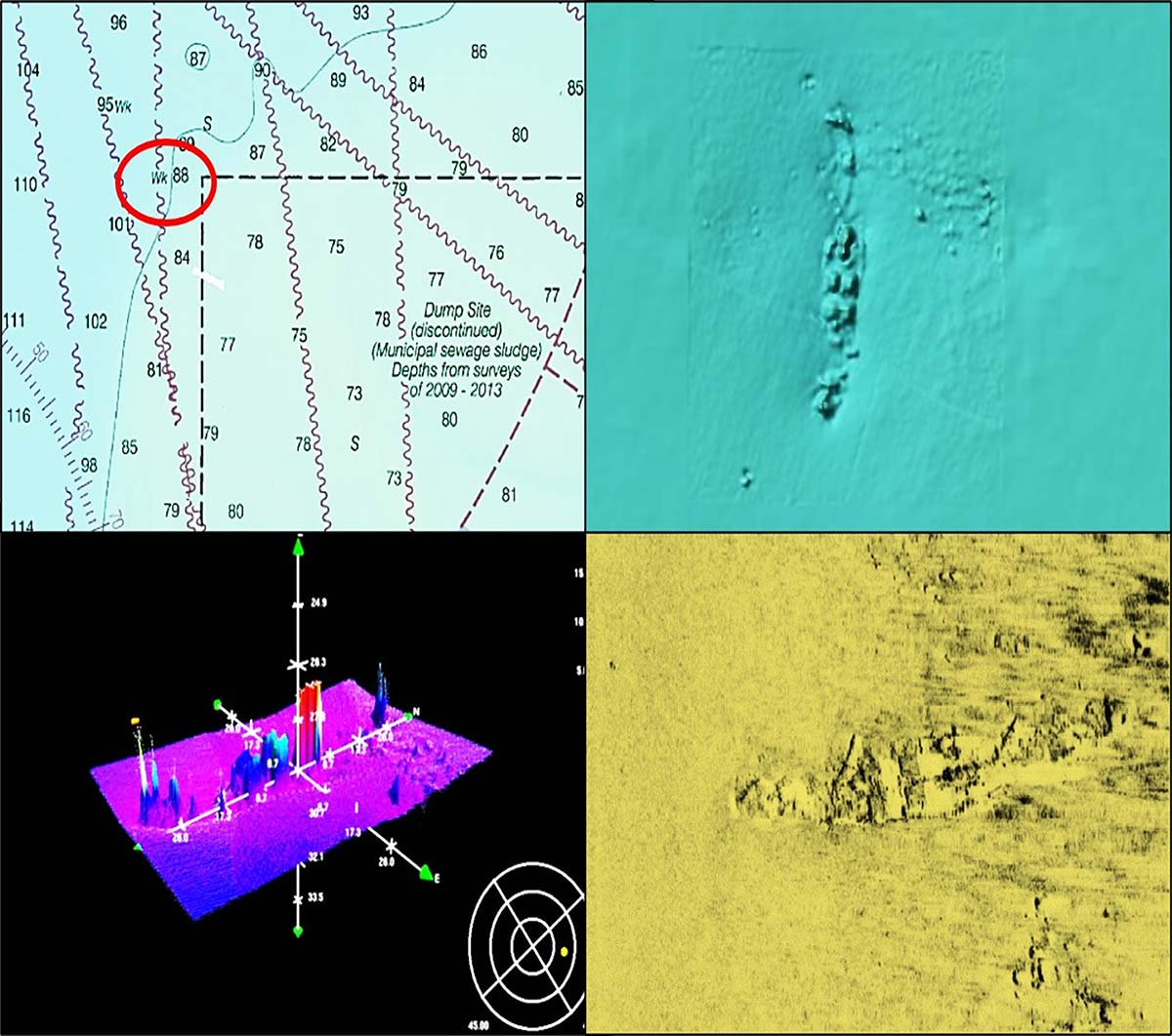
A side-scan sonar-like birds-eye view of the wreckage is available by checking the BDV’s “BAG” Color Shaded Relief box. The hull appears covered by sediment with some remains sticking up from the bottom (see Chart 3). NOS Descriptive Report (DR) H12036 (2009) recorded the wreck as decomposed with a maximum vertical relief of about 14 feet. The report contains a side-scan sonar image and a Teledyne CARIS 3D image of the wreck. The side-scan image, recolored to enhance the image, shows heavily weathered wreckage. The CARIS 3D image, which has a somewhat exaggerated vertical scale, confirms that most of the hull is covered with protrusions upward into the water column.
From all available information including diver reports, what is there are the deteriorated remains of the pilothouse, smokestack, and deck rigging. Diver websites report the site attracts lobsters, sea bass, and tautog.
Wreck Valley Finds
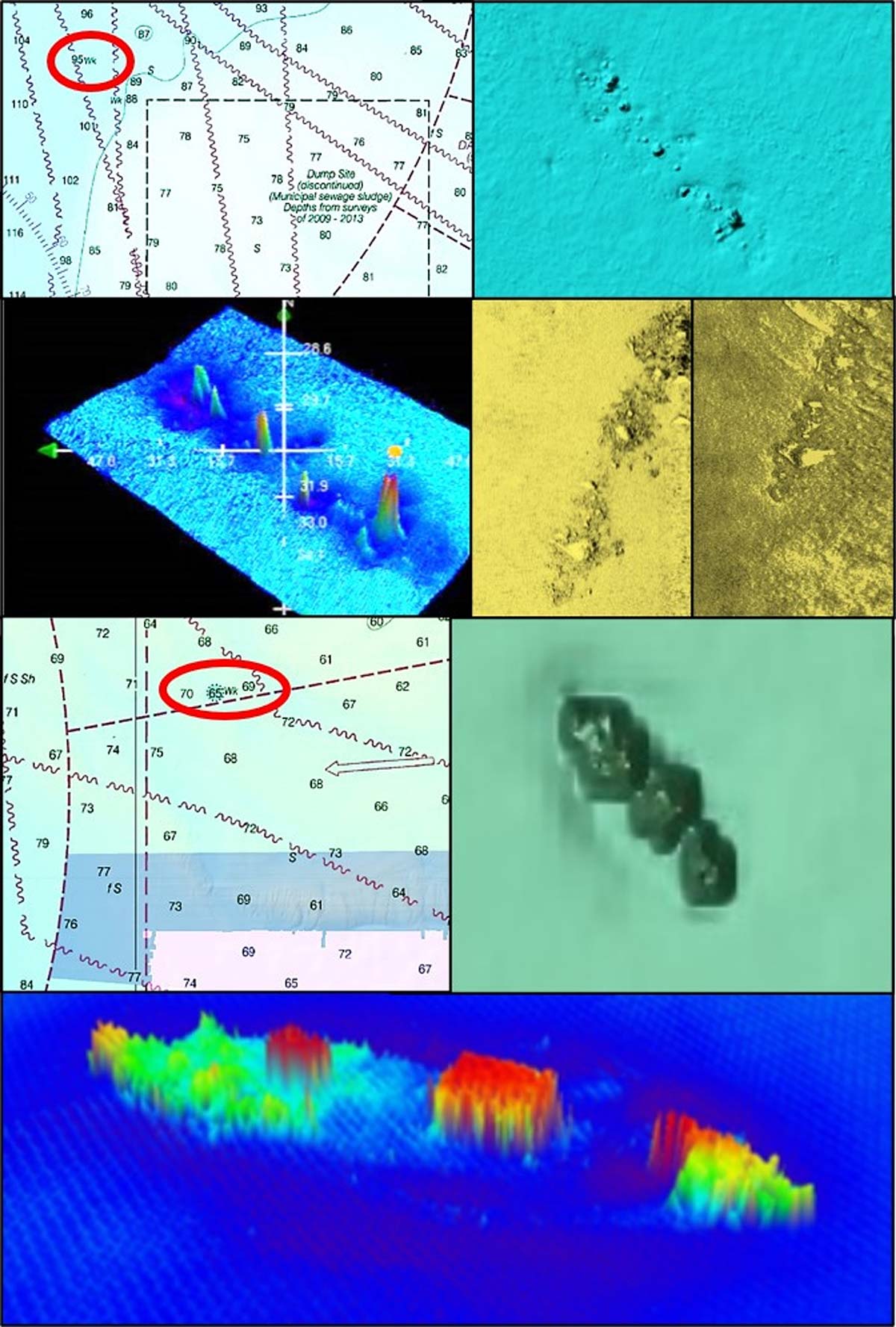
An unidentified wreck lies 1,400 yards northwest of the Mohawk (see top half of Chart 4). The survey party reported a possible wreck about 275 feet long. The BDV “BAG” Color Shaded Relief image shows relatively smooth distributed wreckage with most of what’s there covered with sediment. The DR contains two side-scan sonar images and a CARIS 3D image. All three images show rugged wreckage. One of the side-scan images has dark coarse areas around the wreckage. This suggests possible spilled cargo or ballast. All three images show that there was more there in 2009 when the images were taken than indicated by the BDV BAG image. I found a more recent image (unavailable here due to copyright), which also suggests more wreckage above the bottom than indicated by the BDV image. If in the area checking out the Mohawk, this wreckage is close enough for a quick check out as well.
Another offshore wreck to investigate is the Lizzie D, AWOIS Record #1624, reported by NOS Descriptive Report H12526 (2013) as a converted fishing boat. In fact, she was an 84-foot steam tug that was converted into a rumrunner. The wreckage is located just north of the Nantucket to Ambrose Traffic Lane just east of the circular Precautionary Area (see bottom half of Chart 4). It bears 084 degrees True from Buoy RW “A” at a distance of about 8.5 nautical miles. The location is a shorter run for boats dropping down from Long Island, but still within striking distance for North Jersey anglers.
| MULTIPLE MOHAWKS |
| In an October ’19 Hot Spot of the month author Nick Honachefsky keyed in on another wreck called the Mohawk, an inshore wreck approximately 7-1/2 miles east of Manasquan Inlet that he tabbed “a stop by destination” for sea bass in the fall on their move to the offshore grounds. “Sea bass will colonize the area; many times you can see them ‘haystacking’ above the wreck,” Honachefsky wrote, adding “Savvy anglers targeting humpbacks over 3 pounds will bounce hammered diamond jigs around the debris as the low profile structure doesn’t claim gear like higher relief wrecks will.”
Porgy fishing can also be productive at this particular Mohawk wreck (N 40 1.412’ / W 73 54.265’) in October when according to Honachefsky, “true poke chop size fish up to 3 pounds are hanging around the structure.” He advises to rig up with size #1 beak hooks and use very small pieces of clams for baits as porgy are adept at nipping away at big baits and picking them off the hook. For more about porgy and sea bass at the Jersey Shore this month, check out Nick’s latest article. |
The wreck provides an example of the value of CARIS 3D images in characterizing bottom features. In this case, the BDV “BAG” image shows large rounded objects. The CARIS 3D image depicts a vessel with most of the hull sides and superstructure above the bottom. Lizzie D lies in 70 feet of water with a least depth of 59 feet. The wreck was extensively explored by divers in the late 1970s, and many artifacts were recovered. A detailed description with pictures and graphics is posted at aquaexplorers.com.
By using the resources presented, sportfishermen can obtain an improved understanding of wrecks and obstructions for which more data are available than commonly known. A comparison of available sonar images and renditions can reveal details that show a seemingly nondescript feature as a suitable fishing destination. All three wrecks described above are a bit of a run offshore, so a boat capable of ocean operations is essential.
Always watch the weather and leave the fishing grounds in time to safely reach sheltered waters ahead of threatening conditions. And, always wear a Personal Floatation Device (PFD), even while on a charter boat. It’s too late to put one on after slipping and falling overboard.
The author is former manager of the Maryland artificial reef program for Chesapeake Bay waters and author of “Tidal Delaware River Wrecks, Reefs, Rocks, & Ruins: C&D Canal to Trenton Falls (Mid-Atlantic Fishing Reefs)” available at Amazon. Charts and bathymetry images are processed screenshots from the National Oceanic and Atmospheric Administration’s Bathymetric Data Viewer which can be found at www.ncei.noaa.gov/maps/bathymetry or simply by Googling “NOAA Bathymetric Data Viewer.”


