Tips for improving your personal predictions in the year ahead.
There have been many days when I have seen a car load of hopeful anglers drive up to a boat ramp, tackle shop or pier to find flags standing straight out and the only people around are captains or mates doing maintenance work on their boats or sleepy clerks in the tackle shop.
So how did these fishermen not know that the weather at the shore or beach was going to be bad? Because they listened to the blow-dry weather guy or gal on the TV at home.
The fact is, a beautiful summer day with a cool northwest breeze in Harrisburg can be a complete blowout on Delaware Bay. A strong low-pressure area 200 miles off of Atlantic City will have little or no effect on the weather in Philadelphia, but boy it sure will kick up the waves out of Cape May.
| NOAA ONLINE |
|---|
| The National Oceanic and Atmospheric Administration (NOAA) is the scientific agency within the United States Department of Commerce that focuses on the conditions of the oceans, major waterways, and the atmosphere.,You can find their main marine weather page and map at www.weather.gov/marine from which to choose the coastal National Weather Service Forecast Offices for regionally focused marine webpages that contain coastal forecasts, predicted tides, and buoy observations.,For inshore and offshore forecasts for Southern Monmouth County in New Jersey south down along the Delaware Coast, go to the Philadelphia office forecast; for Raritan Bay and coastal New York select the New York City office. |
Highs & Lows
I am sure there are books you can read that will explain in great detail how weather works, but you really don’t need to be a meteorologist to figure out what kind of weather to expect when you want to go fishing. There will be a weather map in the daily newspaper that I read online and most TV newscasts have weather maps along with the weather report. Pay attention to the H and L symbols. The H means a high-pressure system. The air around a high-pressure system flows in a clockwise direction. When a high-pressure system is sitting on top of you the weather is usually pretty nice—light winds and moderate temperatures.
A low-pressure system has air that moves in a counter-clockwise direction. Low-pressure usually brings in rain and wind. Hurricanes are low-pressure systems.
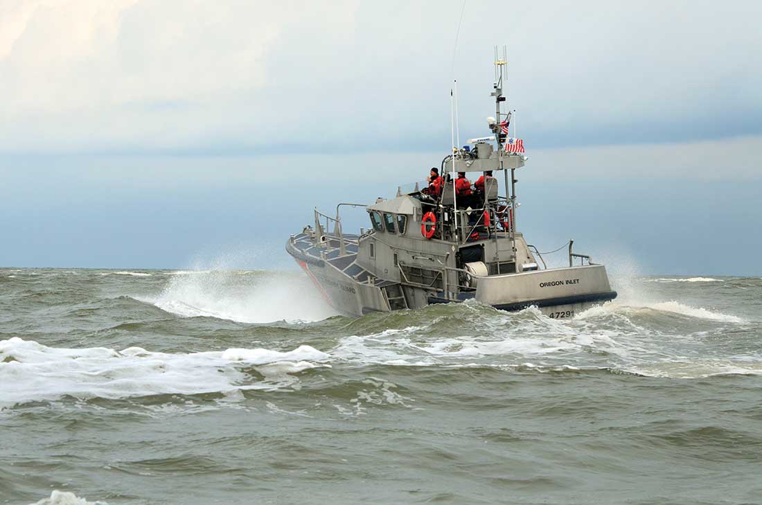
One situation that often occurs off the New Jersey/Delaware coast is a high-pressure system to our north and a low-pressure system to the south. The clockwise direction around the high will combine with the counter-clockwise direction on the low to bring in a strong onshore wind. There may or may not be rain with this wind. When there is no rain, we have a dry nor’easter. Call it whatever you want, the end result is no fishing. There is a strong possibility the local weather report may not mention the fact that seas in the ocean will be running 6 to 8 feet because of the 15- to 25-knot onshore wind.
Of course, you can always go online and check the marine weather forecast for the area you plan to fish. I must check the Marine Forecast for Cape Henlopen to Fenwick Island at least five times a day. This forecast will have the wind speeds when we have a high to the north and a low to the south.
What a marine forecast will not have is the effect the current has on the seas. Take Delaware Bay, when the wind is northwest and the current is going out the seas are generally manageable. But boy, let that current start in against a hard-northwest blow and you are looking at a very nasty ride up the bay. Back in the day when we used to have striped bass in the Cape May Rips a hard northwest wind and an incoming current would build up some very impressive standing waves at the mouth of the bay.
Wind or Fog
The wind direction will also affect the amount of water we get in certain parts of the bay and ocean. A strong northwest wind combined with a low tide will blow the water out of inland bays from North Jersey to Rehoboth Bay. Just the opposite will occur when we have a northeast wind and a high tide.
I have heard people say we won’t have a high tide today because we have a northwest wind. We will always have high and low tides unless the moon falls out of the sky. The water may not reach as high on a northwest blow as it would on a northeast blow, but it still arrives at a high and low point twice during most 24-hour cycles.
Anglers need to know the affect the wind has on water levels in order to get their boats out of the marina, through narrow cuts and over sand bars. I am most familiar with Indian River and Rehoboth bays where some areas are impassable on normal low tides let alone on a hard northwest blow.
And then there is fog. Nothing scares me quite as much as fog. I can deal with rough water because I can see and feel the danger, but with fog I can’t see anything. I can still recall a trip to Brandywine Light with Lark Benelli many years ago when we were both young, brilliant and indestructible. We left Bay Shore on White’s Creek in Lark’s 21-foot Grady-White and headed across Rehoboth Bay towards Indian River Inlet. Once through the inlet it was up the coast to Delaware Bay where we hit a dense fog. No problem. We had laid out a compass course right up the middle of the shipping channel to Brandywine Light.
As we slowly made our way up the channel it suddenly became very dark. I looked up and saw the bow of a very large tanker directly overhead. The only thing that saved us was the tanker’s bow wake. We were pushed aside and cleared the ship’s hull by inches. Then he blew his fog horn. As if we weren’t scared enough.
At that point we headed for Brandywine Shoal and didn’t stop until we were in very shallow water where no tanker could follow. We did catch a cooler full of weakfish, but we came home through the Lewes and Rehoboth Canal and across Rehoboth Bay. A slower, but safer route.
We get fog when warm air meets cool water usually in the spring. It is seldom forecast on local TV and may or may not be in the marine forecast. I have seen fog appear in parts of the ocean and not others that are within sight of each other. Pockets of cooler water meeting warm, moist air will create this and swallow up boats and other objects like jetties.
If you don’t have radar all you can do is slow down and post people on the bow to keep a sharp look out. Turn off radios and stop all conservations. If you find fog at the boat ramp, don’t go out until it clears.
Coastal Temps
Those of us who live at or very close to the ocean or bay realize what an effect these large bodies of water have on our weather. While the land does not hold heat or cold for a long period of time the ocean or bay does. Also, when the wind blows offshore the water close to shore cools and when it blows onshore the water close to shore warms.
This is important for surf fishermen because bait and fish follow the water temperature where they are most comfortable. Depending on what you are after, you may want the water along the beach to be cooler or warmer and that will depend on the wind direction.
Another weather situation common along the ocean is the sea breeze. This is why so many people love to come to the shore in the summer beginning with the Native Americans who came here long before the white man built condos with air-conditioning and running water. As the summer sun heats up the land, the ocean water remains cool and this develops a pressure difference between the land and water. Where there is a pressure difference, the wind will blow.
Now, this may be great if you are on the beach looking for a little relief from the heat, but not so great if you have been on a 22-foot Mako since 4 a.m. and are now taking a beating during the last five miles to the inlet. This is why I now fish inshore and plan my trips to be back at the dock no later than 2 p.m.
The other reason is thunderstorms. Most occur in the afternoon, so having survived more than one and not wishing to push my luck, I don’t stay on the water past the magic hour of 2 p.m. Sometimes they are forecast and sometimes not. I count on them any day when the weather is hot and the humidity is high.
Use all the information you can gather then include your local knowledge to make weather decisions when planning a fishing trip.