Modern marine technology compared to what we used when I was fishing the thoroughfares and creeks behind Ludlam’s Island in the middle of last century is science fiction becoming reality!
My technological baseline was based on stories from the Great Depression when my stepfather rowed a heavy garvey from Sea Isle City north into Ludlam Bay to rake the shallows for clams. His technology and my starting point – boat, oars, wire baskets, and a Shinnecock clam rake. The little gas engine in the double-ended boat that he brought into the family was started with a hand crank! He taught me basic navigation using a chart, course lines, an
An electronic flasher depth finder, astounding in its day, along with a basic AM marine radio, were the major technological advances for his new boat, a 30-foot Troth hand built with white cedar on the banks of Cedar Swamp Creek by old Mr. Troth and his son. I got to see a depth sounder with paper recorder when a summer neighbor put one in his boat.
HIGH TECH ANALYSIS
My first exposure to radar, gyrocompass, and loran came while at the Coast Guard Academy in the mid-1960s. We were also taught ocean navigation using a sextant. Why? The loran set would sometimes stop working, and the sextant was necessary for long-range search and rescue missions and for position keeping aboard ocean station vessels (the Coast Guard provided mid-ocean floating waypoints for trans-ocean commercial flights back then).
For coastal piloting, we also set buoys by taking lines of position using alidades and radar bearings and ranges. Loran C readings were very consistent, but the error factor was beyond geographical tolerances for some coastal and bay waters. Sextant angles using landmarks as reference points were sometimes used to set certain buoys and to double-check positions. Horizontal sextant angles were at the time still the most precise positioning capability in coastal waters.
The side-scan and down-looking high definition sonars in the electronics box on my 20-foot walkaround and now my 18-foot retirement skiff weren’t even science fiction fantasy when I grew up. Dick Tracy’s wrist radio, the stuff of wild imagination for us, is lame when compared to the Global Positioning System (GPS), computer technology, and the Internet which revolutionized modern navigation and armchair scouting. All we have to do is punch some waypoints into a GPS electronic chart and steer to the marks. Or, for boats equipped with an automatic pilot, let the boat take you there!
Once at the fishing destination, scan with a combination of side-scan and down-looking sonar to see the structure and position the boat. More can be discovered in a few hours of scanning than would have taken months or years of boating and fishing to learn, before this technology. See for example a side-scan sonar image shared with The Fisherman by Ben Roberts, Eastern Search & Survey (ESS), of the San Jose wreck (BDV Spotlight: The Winds Of War At A.C. Reef, May 2022 edition).
SEAMLESS MOSAIC IMAGERY
Optimizing fishing time consistent with safety is always a priority for me. So, before getting on the water, I’ll scout promising fishing structure in comfort at home using the Internet. Identifying structure with the greatest mass is my starting point, notwithstanding that smaller reefs also produce. What I’m looking for is a cluster of spots to prospect.
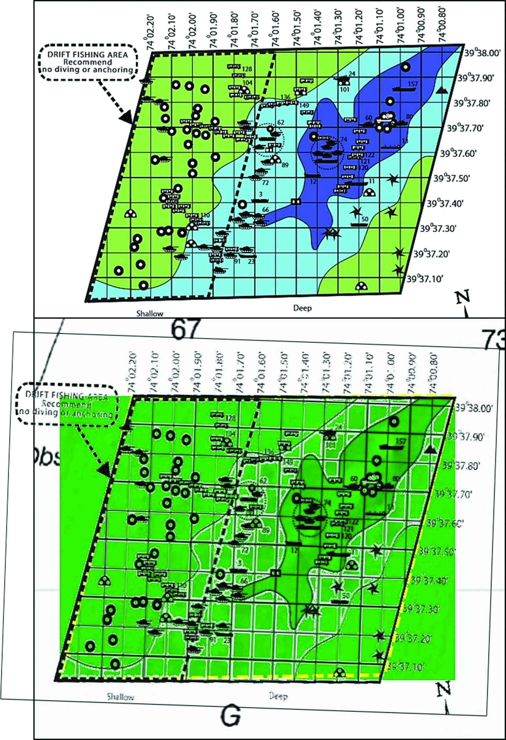
Primary computer scouting applications are the National Oceanographic and Atmospheric Administration (NOAA) Bathymetric Data Viewer (BDV), the Coast Survey’s Automated Wreck and Obstruction Information System (AWOIS), the NOAA ENC Viewer, Goggle Earth, and the Navionics Chart Viewer’s sonar charts and community layer. The latter includes data developed from user uploaded sonar logs. Although not complete, reef masses are sometimes disclosed. And, some enterprising person(s) have already entered the location of most, if not all, the artificial structures at New Jersey’s official artificial reefs in the community layer. I’ll take screenshots of NOAA BDV images, prepare chartlets and graphics, slip them into plastic sleeves, and put them in a binder for quick reference. The workup for the Garden State North Reef presented in Chart 1 illustrates what goes on my crib sheets.
NOAA BDV imagery, an invaluable resource available to the public courtesy of the NOAA National Centers for Environmental Information (NCEI), provides a seamless mosaic image of bathymetry in two formats – Bathymetric Attributed Grid (BAG) and Digital Elevation Models (DEM) color shaded relief. The “BAG” image is a modest definition side-scan-like mosaic of the bottom for some coastal areas and estuaries. The “DEM” mosaic image, which covers all coastal and estuary waters, presents a 3D-like image of bathymetry showing mounds, ridges, and holes. Both include features that were present when the underlying data were collected. Colorizing makes anomalies stand out.
The “DEM” mosaic can sometimes be used to identify reef structures with the greatest mass, even where bottoms are relatively flat and a more detailed “BAG” mosaic image isn’t available.
GET STARTED AS GS NORTH
Most of the New Jersey artificial reefs present irregular bathymetry with high spots when viewed using the “DEM” image. Thus, this data format enables us to identify specific spots with large reef masses that can in turn be correlated with the New Jersey reef program grid drawings. The Garden State North Reef images accompanying the article offer examples of what can be learned. Two charted wrecks which also present as distinguishable anomalies in “DEM” mosaic image are circled in red. Neither are identified by AWOIS. A reef diagram found at njscuba.net places the wreck of the 74-foot clam dredge Adriatic in proximity to the red circle closest to the shoreline in Chart 1.
IMAGE 1 shows the “DEM” image for Garden State North. Irregular relief exists throughout the site and is consistent with the layout of reef materials. The areas with the greatest vertical relief are inside the white dashed lines drawn on the screenshot. IMAGE 2 presents the New Jersey reef program color layout grid and a basic version of the grid superimposed over the “DEM” image. This enables correlating grid reef data with the prominent mounds. Chart 2 shows the result of this correlation. The numbers shown are those used in the reef program grid system table in Chart 1 and Chart 2.
Armed with this information, the next step is checking wreck research and diver websites, along with books that may contain additional details and inconsistencies along with fishing reports. My new first stop is the ESS Google map with side-scan and color multibeam sonar images. Diver websites for New Jersey dive sites and reefs include various surface and deployment pictures for donated reef materials, underwater photos and videos, and diver reports which reveal what to look for on the fishfinder and sonar scans. For example, videos and photos of “Redbird” subway cars show substantial deterioration such as missing tops and partially collapsed sides, leaving thin vertical steel sheets with sharp edges. In contrast, heavy structures such as tanks, tugs, and steel deck and tank barges are often intact and heavily biofouled.
Once on a reef site, I’ll start my fishfinder and sonar scans and fishing where the more durable reef structures correlate with the large mounds shown by BDV images. Note that njscuba.net records Reef #60 as the tug Wagners Point while the wreck identification shown in the grid table is the party to whom the reef is dedicated.
When wreck fishing, unless I’m casting surface and shallow running lures, high cost gear stays in the tackle box if my armchair scouting reveals a configuration that is a major hook snagger. I tie my own bottom rigs and use hooks bought in bulk to conserve costs, and also taking into account that some fishing guests are not seasoned fishermen. I’ll also shift from braid to more abrasion resistant mono and bend on heavier mono leaders than used for light-tackle casting and jigging.
The author is former manager of the Maryland artificial reef program for Chesapeake Bay waters. He is the author of the newly released “Tidal Delaware River Wrecks, Reefs, Rocks, & Ruins: C&D Canal to Trenton Falls (Mid-Atlantic Fishing Reefs)” available at Amazon. Charts and bathymetry images are processed screenshots from the National Oceanic and Atmospheric Administration’s Bathymetric Data Viewer which can be found at www.ncei.noaa.gov/maps/bathymetry or simply by Googling “NOAA Bathymetric Data Viewer.”
NEW FOR ’22?
Located 6-1/2 nautical miles offshore (7.7 miles from Barnegat Inlet at a compass bearing of 170°), Garden State North encompasses roughly 1-square-mile of area in a depth of between 66 and 83 feet. While few deployments have been made to Garden State North by the New Jersey Division of Fish & Wildlife in recent years, the Beach Haven Charter Fishing Association (BHCFA) is actively working to add new components to this Central Jersey reef through work with The Sportfishing Fund. For more information visit bhcfa.net or thesportfishingfund.org