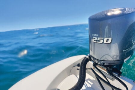
This is definitely the golden age for marine electronics that gets better every year. This year is no exception.
This is a great time to be in the market for marine electronics. Technological advances in the world of PCs, laptops, portable tablets and smart phones are all filtering down into the world of marine electronics at a rapid rate. Big screen color multifunction screens are off the charts, with displays getting larger, more sunlight-viewable, with enhanced touch capabilities. System memory and operating speed are bigger and faster, with software becoming more user-friendly and intuitive with each passing season. Advancements in transducer design, combined with bigger screens, more powerful chips and software upgrades have led to some real paradigm-shifting breakthroughs in fish-finding technology. Many marine VHF radios now come equipped with both onboard GPS and AIS as standard features. Just about every manufacturer now offers a Bluetooth app to control your onboard electronics from a smart phone or tablet. So sit back and enjoy the ride as we explore some of the latest E-gadgets from the major electronics manufacturers.
Furuno
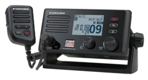
 The Furuno FM4800 is a new all-in-one marine VHF radiotelephone with built-in Class D DSC, GPS receiver, AIS receiver, and simplified loudhailer with intercom. The unit is waterproof to an IP68 standard, the highest waterproof rating for this class of marine electronics. That means it can withstand the IP’s laboratory testing of full immersion for over 30 minutes, making the unit an ideal candidate for vessels with an exposed bridge, where it can be bracket or flush mounted, or even mounted overhead.
While its safety and reliability ratings are impressive, the extensive list of features is what makes this latest Furuno offering so spectacular. The FM4800 is not only a 25W VHF with built-in DSC, it also features a host of other built-ins that make it one of the most versatile VHFs on the market. With its built-in GPS receiver, the FM4800 does not require an external GPS source to enable its DSC functionality, and the unit can be used as a backup source of GPS positioning for other onboard electronics. Its built-in AIS receiver can be used to overlay AIS targets with networked GPS plotters or MFDs, such as Furuno’s NavNet TZtouch and NavNet TZtouch2, or their new GP1871F/GP1971F combo units. You can also share GPS, DSC and AIS information via NMEA0183 or NMEA2000. What’s more, when connected via NMEA2000 to any NavNet TZtouch2 MFD, DSC calling can be initiated directly from the TZtouch2 display by merely tapping on the AIS/DSC target and selecting DSC Call. Additionally, when Man Overboard (MOB) is activated on a TZtouch2 MFD, the FM4800 enters a special mode where you can initiate a distress call by simply pushing the rotary knob.

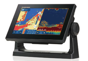
Introduced earlier in 2018, Furuno’s new touchscreen combo units, the GP1871F and GP1971F, have taken on the sleek look and advanced features of their award-winning NavNet TZtouch2 MFDs, but at a truly affordable price. We covered these in detail in a recent Fisherman product review last fall, so check it out. For more information, visit www.furunousa.com.
Garmin
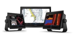 Garmin recently announced the introduction of the GPSMAP 8600/8600xsv series, an extension of its flagship GPSMAP 8600 series that brings premium features like built-in sonar and new BlueChart g3 coastal cartography and LakeVü g3 maps with Navionics data and built-in Auto Guidance1 to smaller, more affordable display options. Available in 10-, 12- and 16-inch displays that feature full HD in-plane switching (IPS) screens with multi-touch control, the GPSMAP 8600/8600xsv series is Wi-Fi enabled and offers full connectivity and networkability so mariners can completely customize their marine electronics system based on their needs and preferences.
With built-in support for sonar, the GPSMAP 8600xsv series includes support for dual-channel 1kW traditional CHIRP, CHIRP ClearVü and CHIRP SideVü scanning sonars, plus ultra high-definition scanning sonar, giving anglers the greatest sonar detail available from a Garmin system to date. These chartplotters also support the full Garmin Panoptix all-seeing sonar product line, including Panoptix LiveScope. Transducers are sold separately. Non-sonar capable versions of each new display, the GPSMAP 8610, GPSMAP 8612 and GPSMAP 8616, are also available.
The new GPSMAP 8600/8600xsv series is the first to come preloaded with Garmin’s exclusive BlueChart g3 coastal charts and LakeVü g3 inland maps with integrated Navionics data and auto guidance technology. For superior clarity and sunlight readability, the new GPSMAP 8600/8600xsv series offers full-HD IPS touchscreen displays that provide consistent, accurate colors that can be seen from all viewing angles, even with polarized sunglasses. The maximum glass design can be yoke, flush or flat-mounted, enabling edge-to-edge installation of multiple displays. The premium processing power found in the GPSMAP 8600/8600xsv series significantly benefits all onboard sensors like sonar, radar, cameras, video and digital switching, and enhances the user experience across the entire network. With SmartMode, these MFDs are designed to give the user quick, one-touch access to the information they care most about. Users can configure and customize their entire system for activities ranging from docking, cruising, fishing, and anchoring with just one touch. These newbies are fully network capable with NMEA 2000 connectivity and the Garmin Marine Network to easily build a customized electronics suite including sonar, radar and autopilots to instruments, cameras and multimedia. The screen can even be spilt to show up to six different features simultaneously, including HDMI video input. For more information, visit www.garmin.com.
Humminbird
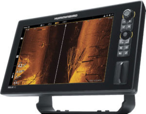 The new SOLIX Series second generation (G2) units continue to build on Humminbird’s commitment to giving anglers a more complete picture of the water beneath them to help them find and catch more fish. MEGA+ Imaging extends Humminbird’s imaging capabilities down 200 feet for MEGA Down Imaging+ and 200 feet to each side with MEGA Side Imaging+. Humminbird’s MEGA+ Imaging technology offers three times greater performance than traditional 455 kHz frequencies. It provides their clearest, sharpest imaging returns ever, unlocking more fish and structure with 20 percent more detail than the standard MEGA Imaging technology.
SOLIX G2 units also come equipped with Dual Spectrum CHIRP sonar, engineered to help anglers see individual fish, clearly identify bait and structure and reach greater depths. Anglers can easily see fish, lure and activity along the bottom in more detail with fewer setting adjustments. Dual Spectrum CHIRP allows anglers to choose between wide mode, showing bigger and better fish arches, or narrow mode, maximizing detail and target separation. The SOLIX G2 comes standard with Humminbird’s Cross Touch Interface, letting anglers operate the unit via touchscreen or keypad, all while customizing the screen with up to four independent viewing panes. In addition to providing sharp imaging returns, the SOLIX G2 units offer advanced mapping capabilities to identify fish-holding areas and eliminate non-productive water. The SOLIX G2 units come equipped with AutoChart Live technology that creates and saves structure maps on any body of water.
Bluetooth is built into every unit, allowing anglers to sync smartphones to the units. Text messages, missed calls, signal strength and other notifications appear right on the Humminbird display, so phones can stay safely in pockets where they belong for hands-free fishing. It creates a flawless on-board network of electronics and connectivity. Wi-Fi is also included. For plug-and-fish networking, high-speed ethernet provides easy connectivity to Humminbird 360 Imaging, Minn Kota i-Pilot Link, Humminbird CHIRP radar and additional SOLIX or select HELIX units. The new units are fully compatible with Humminbird LakeMaster charts, SmartStrike and Navionics+ and HotMaps Platinum+. Users are also able to sync each unit with their smartphone using the Humminbird FishSmart app, to search for available software updates and send the files wirelessly to the fishfinder. All SOLIX units come with a two-year manufacturer’s warranty. For more information, visit www.humminbird.com.
ICOM
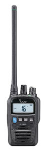
 The new ICOM M330 series gives you the same performance and feature set as the M324 series, but now within a smaller package to fit in tight spaces. With an affordable price tag that should enable the M330 VHF to find its way on a variety of coastal sport fishing craft, this marine radio doesn’t skimp on user features and offers ICOM’s exclusive AquaQuake draining feature, 25 watts of power, an6 IPX7 waterproof rating, scan/select scan functionality and ICOM’s exclusive user interface for ease of use. The M330G model includes a GPS receiver and an easy to install external GPS puck antenna for better accuracy and performance. The small compact GPS puck antenna provides your location, bearing and speed by using information from GPS, GLONASS and SBAS. This information is used for digital selective calling (DSC) calls. Hook up the GPS puck antenna for the most accurate GPS and DSC functionality to work.
The M330’s small size makes it easy to install into vessels with limited space. The dot-matrix display is clear and easy to read. A combination of the directional keypad and soft keys provides simple, smooth operation. Most used functions are assigned to soft keys for quick one push function access. Additional features include AquaQuake draining function to shed water from collecting on the speaker; built-in Class D DSC with a CH70 dedicated receiver; common NMEA interface for external GPS/NAV connection; tag scan and favorite channel functions; dual/tri-watch function for monitoring CH16 and/or call channel; a priority scan function; display and keypad backlighting; weather channel with weather alert; plus a 3-digit or 4-digit channel display select function. For more information, visit www.icomamerica.com.
Lowrance
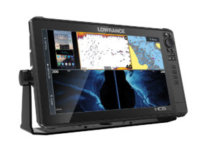 Lowrance recently introduced its new HDS LIVE high-performance line of fishfinder/chartplotters, delivering powerful real-time sonar, charting and next-gen connectivity features. Active Imaging 3-in-1 sonar combines Lowrance CHIRP, with SideScan and DownScan Imaging allowing anglers to quickly search fish-holding structure, and enhances FishReveal with higher-level clarity and target separation. Active Imaging 2-in-1 sonar includes Side and DownScan Imaging and is perfect for use with a separate traditional sonar transducer. Simple to use without the need to change frequencies while fishing in most conditions, Active Imaging 800 kHz provides crystal-clear detail with uncompromised range. For anglers needing to see further than 120 feet, Active Imaging can also operate at 455 kHz. Active Imaging enhancements, including greater resolution, a cleaner 3D view and a new Custom Depth Shading feature, are available to existing StructureScan 3D modules through a free software update.
LiveSight sonar delivers the most detailed views of fish, down to every turn and flip of the tail, as they swim in and around cover. You’ll be fishing in real-time as you watch fish react to your lure, see how they are relating to structure and gain insight on what will work, what won’t and what to do next. When using LiveSight forward in conjunction with the Lowrance Point-1 GPS antenna, an innovative on-chart indicator shows the direction the transducer is pointed, allowing anglers to line up on a waypoint or pinpoint the structure they are trying to fish.
Genesis Live charting delivers real-time, custom-mapping capabilities, which uses digital depth to create depth-contour overlays on charts. Incredibly easy to use, users can control contour transparency, density of contours drawn on the screen up to unprecedented half-foot intervals, depth and safety shading color palettes and more. Charts can quickly and easily be saved to an SD card for continuous use.
HDS LIVE allows anglers to display important fishing information and entertainment from their smartphones on their sunlight viewable displays. Users can view their smartphone in full-screen or split-screen windows via HDMI connection allowing them to stream video, view Google Maps and fishing data on the HDS LIVE touchscreen, all while their phone is safely stowed. HDS LIVE features a stunning new low-profile design with edge-to-edge glass; a SolarMAX HD screen; bracket, flush and rear mounting options; user-programmable keys; and an optional fully-programmable Bluetooth remote. HDS Live MFDs are available in 7-, 9-, 12- and 16-inch display sizes. Active Imaging can be purchased as a bundle with HDS LIVE or as a separate accessory. For more information, visit www.lowrance.com.
Raymarine
 FLIR Systems recently announced the introduction of the Raymarine Element, a new generation of advanced, combination sonar and GPS displays. Featuring the acclaimed Raymarine RealVision 3D and new HyperVision sonar technology, the Element series delivers lifelike imaging and helps meet the demands of coastal anglers with advanced sonar, versatile mapping capabilities and a highly intuitive user experience.
Building on the success of FLIR’s award-winning Raymarine Axiom navigation displays, the Raymarine Element incorporates integrated patent pending RealVision 3D sonar technology, improving anglers’ underwater views with 3D bottom imagery and more precise location of fish targets. Element also introduces new patent pending HyperVision 1.2-megahertz sonar technology, featuring ultra-high Compressed High Intensity Radiated Pulse (CHIRP) sonar frequencies. HyperVision enhances the DownVision, SideVision and RealVision 3D sonar, allowing anglers to see structure, vegetation and fish with lifelike detail.
Optimized for a simplified user experience, Element’s new LightHouse Sport operating system and intuitive keypad controls let anglers quickly mark their favorite fishing spots and create their own high-definition bathymetric maps using the new Raymarine RealBathy real-time sonar map generator capability. Element’s user experience is further enhanced by an onboard quad-core processor, delivering instantaneous chart redraw, smooth RealVision 3D imaging and fast response while on the water. The new Raymarine Element series takes Ramarine’s most advanced sonar technology and operating software and makes it available to a larger audience of recreational boaters in an affordable, all-in-one package. The Element series consists of 7-, 9- and 12-inch display models. For more information, visit www.raymarine.com.
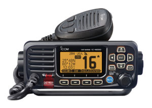
Simrad
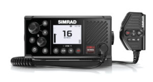 New for 2019 is the Simrad RS40 VHF radio. Featuring a sleek design with wireless handset capability, removable microphone, Class D DSC functionality and built-in GPS, the Simrad RS40 replaces the RS35 with significantly upgraded VHF radio functionality. With its integrated GPS receiver, the Simrad RS40 now has four ways to ensure GPS reliability in the event of an emergency. A GPS antenna in the face of the radio is perfect for open-air installations and the SMA connector can be coupled with a GPS-500 antenna. NMEA 0183 and NMEA 2000 connections allow the user to get GPS data from a chartplotter or from another antenna that’s already in the system. The Simrad RS40 also answers the call for increased situational awareness on the water. The built-in dual channel AIS receiver monitors the position of nearby AIS-equipped vessels to assist in collision avoidance in crowded waterways. The information is clearly viewable on the Simrad RS40’s screen or can be overlaid on top of a chart or radar through a compatible multifunction display. Users can share recreational cruises and sportfishing trips with up to five friends using Track Buddy, which requests the location of another VHF radio using a digital selective calling (DSC) position request.
The new Simrad RS40 offers the option to pair up to two wireless handsets, sothe radio can be taken anywhere onboard. The removable fist microphone can beconnected to the front or rear of the radio and an optional extension cable allows the radio and mic to be mounted separately. Other unique features include a Navigation mode, which displays speed and course, and a Man Overboard (MOB) function, which drops a waypoint in the current location and provides distance and steering instructions to retrieve a person in the water. The waypoint is also transmitted over the NMEA 2000 hub to the rest of the network. The RS40 offers an increased level of safety in all conditions with DSC for easy calls to friends and in emergency situations even if the rest of the on-board electronics are powered down. Simrad RS40 is simple to install with a low-profile, front-mount design that matches perfectly with Simrad GO, NSS and NSO navigational displays for a sleek and cohesive dash. Easy channel scan and a “favorites” option enhance the user-friendly functionality of the large, clear white dot-matrix LCD screen. For more information, visit www.simrad-yachting.com.
Si-Tex
 Si-Tex Marine Electronics has added two powerful, feature-rich MFDs to its 2019 product line up, the NavPro 900 and the NavPro 1200. The new Si-Tex NavPro Series offer coastal anglers everything they need to navigate, catch fish and enjoy their time on the water.
The NavPro 900 features a 9-inch LCD display and is ideal for boats ranging from small center consoles and pilothouse fishing boats, while the 12-inch display NavPro 1200 is a great choice for larger bluewater center consoles. Both feature rugged IPX6 waterproof construction and NMEA 2000 and NMEA 0183 connectivity for easy integration with other onboard electronics. Whichever NavPro unit they choose, boaters will enjoy versatile Hybrid Touch Control for easy, intuitive operation using either the touchscreen display or a combination of robust hard keys, four-directional pad or rotary knob controls. For added versatility and use throughout a boat, the NavPro “Mirror Control” feature and companion app enable compatible mobile devices to serve as a remote display and/or remote control for operating the MFD.
Both units feature an integral 10Hz GPS/GLONASS receiver (with external GPS option) and run the latest C-MAP 4D cartography for the utmost in chart detail and advanced navigation features. Serious fishermen will appreciate the option of integrated or Black Box CHIRP sonar available in 46-65kHz, 100-140kHz or 160-200kHz frequency ranges for superior fishfinding and bottom structure detail under a wide range of conditions, environments and fishing situations.
Today’s tech-savvy boaters like to stay connected, and the new NavPro Series delivers with powerful built-in WI-FI and Bluetooth. This allows for easy software updating over the Internet without requiring a PC or special app. It also provides boaters with automatic storage and synchronization of critical data using Captain Cloud, eliminating worries about losing precious waypoints, fishing hot spots or routes. With Captain Cloud activated, the MFD will automatically transfer data to secure cloud storage when the vessel is in range of a WI-FI connection. The new NavPro Series is affordably priced and backed by the company’s two-year warranty and customer-friendly Long Island-based service department. For more information, visit www.si-tex.com.
C-MAP
 C-MAP has released a new feature for its C-MAP chart cards:coastal high resolution bathymetry (HRB). Offering anglers the latest and most detailed contour data for their C-MAP charts, Coastal HRB enhances current MAX-N+ cards with the highest resolution depth contour detail available. Combined with the custom depth shading available in all Navico chartplotters, it is especially helpful to the fisherman who is looking to highlight those areas where fish gravitate. Available now, Coastal HRB comes with new chart purchases from data version v42. For more information, visit www.c-map.com.
 Navionics
 Navionics
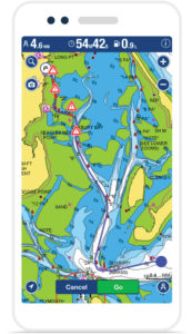
The popular Navionics Boating App offers the same great detail found on GPS chartplotters and transfers it to your favorite Apple and Android devices. The app is available as a free download from the iTunes App Store and Google Play for Apple and Android mobile devices. Navionics Boating users can conveniently shop In-App for affordable charts of anywhere in the world and have the ability to purchase and seamlessly merge additional coverage as needed. Advanced feature upgrades such as Nav Module, Autorouting and Advanced Map Options are available across all regions providing added savings and convenience. For the latest compatibility with Apple and Android devices, visit the Navionics website at www.navionics.com.