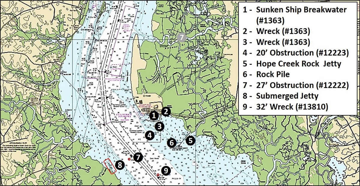
Artificial Island, home to the Hope Creek and Salem Nuclear Generating Stations, is a diked manmade island. It was originally constructed as a spoils area for dredged material from river navigation projects. The southern portion was traded with the parent company of the power plants to enable their construction. Large bottom structures marked as Sites 1 to 6 on the Chart are immediately south of the facilities at the plant.
Located in New Jersey waters, Site 1 is a massive unofficial artificial reef that was originally established as a breakwater. This substantial feature isn’t part of the New Jersey artificial reef program, but is a sunken ship breakwater formed by WWI freighters and tankers constructed from wood and referred to as “woodies”. Wood was used because of shortages in steel. Seventeen ships comprise this “ghost fleet”. The feature is recorded as File 1326 in the Coast Survey’s Automated Wreck and Obstruction Information System (AWOIS).
These ships were part of a larger build program. A few woodies saw service after the war, but all were obsolete. About a 100 were salvaged in the Potomac River. Their burned-out hulks, most part of the so-called Mallows Bay “Ghost Fleet”, recently were incorporated in a new National Marine Sanctuary. The 15 ships in the charted breakwater off the power plants were left intact. All however have succumbed to progressive deterioration and are now awash or sunk.
There is a charted Coast Guard security zone off of the nuclear plants where. The eastern edge just touches the western end of the breakwater. Check the status of restrictions before fishing (or duck hunting) here and along the shoreline clear from Alloway Creek down to the Hope Creek area. For reference, the east-west outer line of ships is more than 1,000 feet offshore.
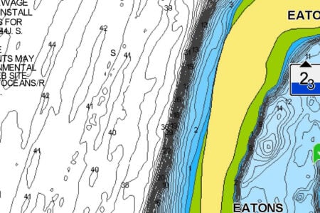
Site 3 marks a single wreck that covers and uncovers. Best guess, this woodie broke free and stranded at coordinates 39° 27.311N, 75° 31.487W. Google Earth is a very valuable resource for scouting shoreline ruins, wrecks that uncover and uncover, and subsurface features in very shallow water. The historic images generally go back to the mid-1980s. Although quality varies, especially for older images, sometimes features are shown when water levels are low which aids in their characterization. For some wrecks and ruins, it’s also possible to view progressive deterioration to help better understand what’s there now. Nearby at Site 4 is a 20-foot obstruction (AWOIS #12223) of uncertain extent at coordinates 39° 27.254N, 75° 32.236W.

The Hope Creek entrance channel is protected by a very long rock jetty now variously submerged or awash. There’s a large rockpile around the Hope Creek Jetty Light at the southeast end of the jetty, marked as Site 6. Check here for stripers. Site 7 (AWOIS #12222) is a 27-foot obstruction in Delaware waters. This feature displays as a dimple in Digital Elevation Models (DEM) Color Shaded Relief when using the Bathymetric Data Viewer (BDV). This National Oceanic and Atmospheric Administration online application provides close to shore-to-shore “DEM” coverage. The dimple indicates that something is there rising above the bottom.
There’s another submerged jetty over on the Delaware side in front of Rays Ditch inlet at Site 8 (AWOIS #3255). The northwest (outer) end was at approximate coordinates 39° 26.150N, 75° 33.604W. It is covered in most satellite images. A number of ditches were dug during Delaware’s early history to support agriculture. The presence of a jetty at this location protecting the inlet entrance suggests that agricultural or fish products were at one time shipped through the inlet. Try casting to the northwest end for stripers when current is running, especially an ebb when baitfish may be swept out of the creeks out towards the jetty.
Site 9 is a 32-foot wreck (AWOIS #13810) at coordinates 39° 25.716N, 75° 31.513W, just north of Buoy R “48”. This puts it on the New Jersey side of the line. This unidentified wreck was found with side-scan sonar during a 2002 survey, although no images are posted. However, it displays as a prominent dimple in “DEM” Color Shaded Relief, so there’s something there to prospect.
This section of the lower river has a lot of structure. When fishing it, pay attention to the security zone, weather, and fishing license jurisdictions. Also be alert for ship and tug and barge traffic. Ships are constrained to the federally maintained navigation channels, so give them their operating space.
Dig deeper into this and other locations with NOAA’s Bathymetric Data Viewer (BDV) at www.ncei.noaa.gov/maps/bathymetry or simply by Googling “NOAA Bathymetric Data Viewer.”