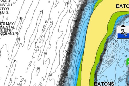
It doesn’t require much imagination to guess how Long Sand Shoal earned its descriptive name. Stretching 6 miles from its east-end bell to its west-end gong, Long Sand Shoal spans the towns of Old Saybrook and Westbrook, Connecticut, and its midpoint rests 1-1/2 miles south of Cornfield Point. The shoal is composed of a narrow band of bottom deposits, which oceanographers describe as coarse sand formed into “sand waves” and “megaripples” from the strong currents sweeping through eastern Long Island Sound. The shoal is a popular destination for anglers from Niantic to Clinton.
The shoal’s eastern half averages about 14 feet at the high points, while the central portion and western half average only 4 to 9 feet deep. Waters to the north side of the shoal average about 40 feet deep; however, waters to the south side plummet to 100 to 150 feet deep. The combination of abrupt shoaling and swift currents, when coinciding with a stiff, opposing breeze, can stack up great lengths of treacherous rip lines here.
“The eastern end of the shoal,” said Q Kresser, manager at River’s End Tackle in Old Saybrook, “is the better area for striped bass fishing. This section runs northeast and southwest. Most guys expect to drift directly across it. But one has to remember that the current runs east/west, so, in fact, you’ll drift diagonally across the shoal.”
Try trolling surgical-tube rigs or parachute jigs for keeper bass here, but the larger bass usually only want bunker. Three-way rigging live bunker or eels has been the most productive method for the biggest fish. Bluefish often invade the same areas as the stripers, which offer good action once the water heats up and the bass go off the bite.
“If you invest a little time searching on the east end of the shoal,” said Kresser, “you’ll find some large boulders. There’s also an old range I refer to: If you line up the two lighthouses at the mouth of the Connecticut River and run to the rip, it’ll put you in a generally productive area where you’ll find a bowl in the sediment formation. It’s a good location to get you started.”

On the western end of the shoal, fluke are the most commonly targeted species. “They tend to be plentiful but short,” said Kresser. “If you’re looking for a spot for the kids to reel-in a bunch of fluke for catch-and-release; in other words, if your goal is quantity not quality, this is a good place to take the family for a day on the water. Even the inexperienced can often catch enough short fluke on a squid-tipped bucktail to get sore.”
But if you work the shoal early in the season before the doormats get picked over, you can have a decent shot at legal fish. You can catch fluke along the entire shoal, but the action is usually best on the western end when drifting along the slope with the diagonal current. Some days, you may never drift over the shoal but ride along parallel to it if the breeze is right, which keeps you in the sweet spot for a long time.
“The surprise fish here is sea bass,” said Kresser. “The south side drops off quickly, and there seems to be structure everywhere, including some wrecks. The skilled angler can accumulate some sea bass spots if he explores the deeper water. I prefer a high-mid-low rig with 2/0-3/0 bait-holder hooks sweetened with squid chunks or clams.”
The best ramp for Long Sand Shoal access is located under the I-95 bridge in Old Saybrook. For up-to-date information, tackle and bait, visit nearby River’s End Tackle www.riversendtackle.com.