Roffer’s Ocean Fishing Forecasting Service (ROFFS™) provides an overall update of the spring oceanographic conditions offshore of the Northeast, focusing in on the Mid-Atlantic Bight region and its canyons. They utilize mainly satellite derived sea surface temperature (SST) and ocean color/chlorophyll images. This article presents the present ocean conditions and what it means for the upcoming late-spring to summer fishing season for the New Jersey/New York to Massachusetts area.
For forecasting short-term oceanographic conditions related to finding fish, ROFFS™ uses real-time direct observations. Evaluating the preseason conditions provides insight into future seasonal trends for fishing. Experience and understanding the ocean – atmospheric dynamics – has resulted in moderate success in forecasting seasonal trends of fishing productivity based on the stepwise progression in the location of the fishes’ preferred habitat based on SST and water color.
The good news is the atmospheric temperatures are finally starting to warm and the SST will start to increase at a more rapid pace as May progresses into June. Recent reports have already confirmed a number of yellowfin tuna, sharks, wahoo and even mahi catches off of Oregon Inlet to Cape Hatteras, NC. Based on historical observations, we anticipate that these fish, along with other tuna, dolphin, wahoo and then billfish will move to the Northeast region from the Gulf Stream and into the relatively large eddy features that move over the canyon areas.
Nowcast Analysis
One of the most valuable features when trying to forecast the Northeast Region is the number, size and location of clockwise rotating, warm-core Gulf Stream eddies that are located north of the Gulf Stream region from south of Georges Bank to offshore of New York, New Jersey to Delaware areas. These are eddies that have broken off from the Gulf Stream and tend to slowly drift westward toward the Atlantis Canyons to Hudson Canyon and then in a southwestward direction toward the Norfolk Canyon before being pulled back into the Gulf Stream. The environment associated with warmer water and the mixing boundaries of the eddy features provide valuable habitat for highly migratory pelagic fish that enter this region in the spring and early summer seasons. This year already looks more promising than 2017.
The spring 2018 satellite data shown in Figure 1 and 2 may provide insight into the upcoming fishing season. Figure 1 was derived from a variety of U.S. (NOAA and NASA) and European (ESA) satellites to show the SST during May 01-03 period. Figure 2 was derived from the NASA MODIS ocean color satellites showing the ocean color/chlorophyll image data during this similar May 01-07 period with some of the data being provided by the University of Delaware.

The most exciting news is that we observe a few of these clockwise rotating warm core Gulf Stream eddies stacked up north of the Gulf Stream from south of Georges Bank to south of East Atlantis Canyon and most importantly is the larger eddy centered offshore between Hudson Canyon to Block Canyon. This main eddy south of Block Canyon is the one to watch as is drifts west then southwest. This could be the feature that the New Jersey crowd will be targeting for good fishing conditions over the Toms Canyon to Lindenkohl Canyon, then Wilmington Canyon to Baltimore Canyon during the summer. These eddies, although still relatively cool and greener in color, will start to warm and blue rapidly over the next few weeks. Also, depending on proximity, these eddies will interact with the Gulf Stream and will be pulling new warmer Gulf Stream water toward the canyon areas and providing the pathway for the tuna and other migratory fish to enter the canyon areas. In fact, we have already heard of signs of life (mainly shark and bluefin tuna reports) in the northern and western eddy water in the Hudson to Block Canyon and flowing toward Toms Canyon area. Some of the water’s SST is already up to 64°F to 65°F near the Fish Tails and further southwest the water over the 500 fathom contours have already had reports of life in them in and around the Baltimore to Poor Mans Canyons.
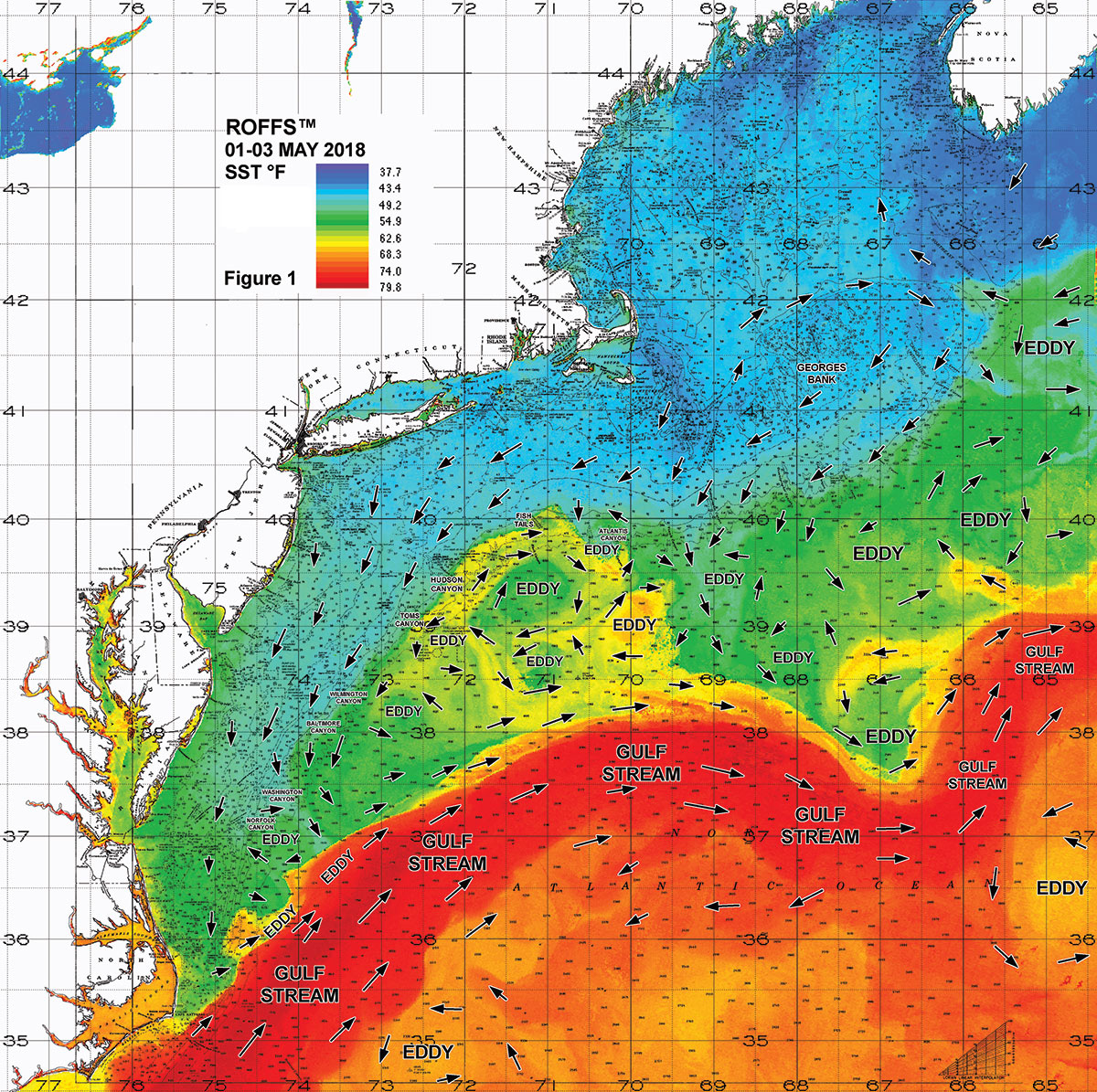
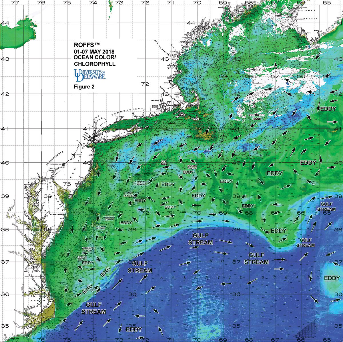
It is important to look further east to the conditions forming east of Veatch Canyon to Oceanographer Canyon and southeast of Georges Bank. As these will likely be the features that progress west, then southwest, and what fishers will be targeting during the mid-to-late summer season influencing the Gulf of Maine to the canyons south of New York to the canyons offshore of New Jersey, Delaware and Maryland. It appears that if the eddies we see now remain in tact and drift in the traditional westward direction, it has the potential to be a successful fishing season offshore of the Northeast U.S. later this spring and into the summer. As always, it only takes a few days to a week for the Gulf Stream to shift and push farther north and form more warm-core eddies to further improve the fishing conditions so please contact ROFFS™ for updates. We are not concerned about the lack of blue water over this region at this time because we are in the peak season of the spring algae bloom (as evident in the large abundance of greener water in Figure 2). This is an annual event that provides the food for many of the baitfish species for the next month or two.
Final Thoughts
Based on what we have been observing over the last several weeks it seems that the tuna and sharks will be in some of the northern canyon areas (and farther inshore) by late May and certainly by early June and a productive season for sharks and tuna then dolphin, wahoo and marlin is likely as you progress into the summer. It has been a cooler than normal spring and a slow start to the season and the majority of the population of fish may be arriving slightly later than normal. However, the large warm core eddy south of Block Canyon and east of Hudson Canyon is already providing some favorable offshore conditions for sharks and tuna.
We encourage you to take a look at these early season conditions and get your boat ready for when the weather permits. The bottom line is, the existing eddies and oceanographic conditions suggest, especially for the New Jersey, New York, Connecticut, Rhode Island crowd that you should be ready now to go offshore. Get your boats in the water, as tuna, shark and swordfish have already arrived in some of the northern canyon areas. Keep in mind that during 2016 and 2017 some of the best tuna fishing occurred in June.
| FOR UPDATED INFO AND CONDITIONS |
|---|
| Contact ROFFS™ (1-321-723-5759 / [email protected] / www.roffs.com) for up-to-date fishing conditions and where the better fishing locations will be tomorrow. Their experienced satellite and fishery oceanographers will continue to monitor the Northeast’s oceanographic conditions closely as the shark and tuna season quickly develops and the summer fishing season rapidly approaches. This info can be invaluable when it comes to saving time and fuel. |