And now there are four!
“If one’s an anomaly, and two’s a coincidence, will three or more show a pattern?”
That was the lead sentence in our first published piece of this year (Born To Run: Hudson River To Canyon Striper) on the status of our 2019 Northeast Striped Bass Study from our January edition. By now everyone along the Striper Coast is aware of the results; two post-spawn striped bass caught by our research team at The Fisherman, Gray FishTag Research and Navionics in May of 2019, tagged with high-tech MiniPSAT devices to track migration habits during a five-month stretch, ultimately showing returns from the offshore canyons including the Hudson, Block and Veatch.
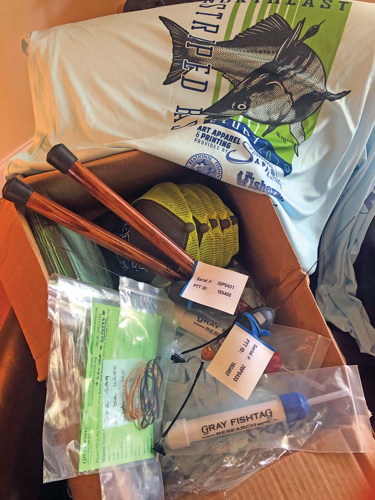
Two $5,000 “pop-off” satellite tags which incorporate light-based geolocation for tracking, time-at-depth histograms for measuring diving behavior, and a profile of depth and temperature, showing two very distinct paths in waters where we typically wouldn’t expect striped bass to swim.
There’s been some skepticism of course with some questing whether a big white shark gobbled up these stripers before heading east with a belly full of bass. However, the data stored inside the Wildlife Computers MiniPSAT devices – which amazingly were physically recovered by beachcombers in Massachusetts and New Jersey – shows both tagged fish were alive and swimming along the offshore grounds when the tags detached.

We had grand plans in 2020, and with financial support from Navionics, Tsunami Tackle, AFW/HiSeas, Southernmost Apparel and the Recreational Fishing Alliance – on top of the thousands in individual donations from The Fisherman readers, regional advertisers, and local fishing clubs – the Northeast Striped Bass Study was poised to deploy up to a half-dozen MiniPSAT devices this past spring. “The plan was to have multiple boats ready to go at one time, with a full Gray FishTag Research team in New York again during the week of May 18,” said Mike Caruso, publisher of The Fisherman and an advisor for Gray FishTag Research, adding “It was going to be even more groundbreaking than in 2019.”
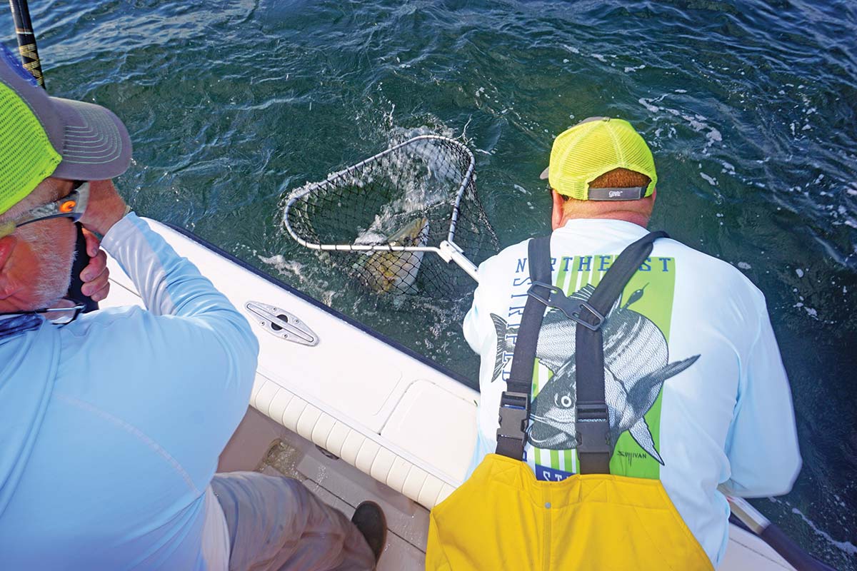
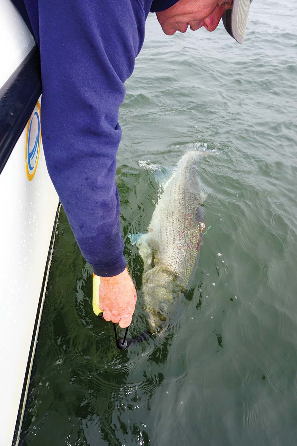
Due to travel restrictions and the shutdown of Wildlife Computers in Washington State where the devices are built, we missed the height of the post-spawn Hudson River bite by roughly two weeks. But thanks to a determined crew at Gray FishTag Research in Florida and a little improvisation, we hit the Jersey Shore spring run off Sandy Hook with a pair of tags, one deployed Thursday, May 28 and another for the following Wednesday, June 3 while fishing with study supporters David Glassberg and Chuck Many aboard Chuck’s boat, Tyman. The pandemic-related audible paid off with a pair of 46-inch plus stripers, appropriately named Cora and Rona.
Tag Return #1
So the $10,000 question we’ve all been waiting to answer with baited breath; where did Cora and Rona eventually get to, and did they follow a similar offshore path to what Freedom and Liberty did during the 2019 study? Once again – just as in 2019 – our first two tag returns of 2020 reveal two coastal stripers taking a rather incredible journey into depths that few would’ve ever expected from striped bass.
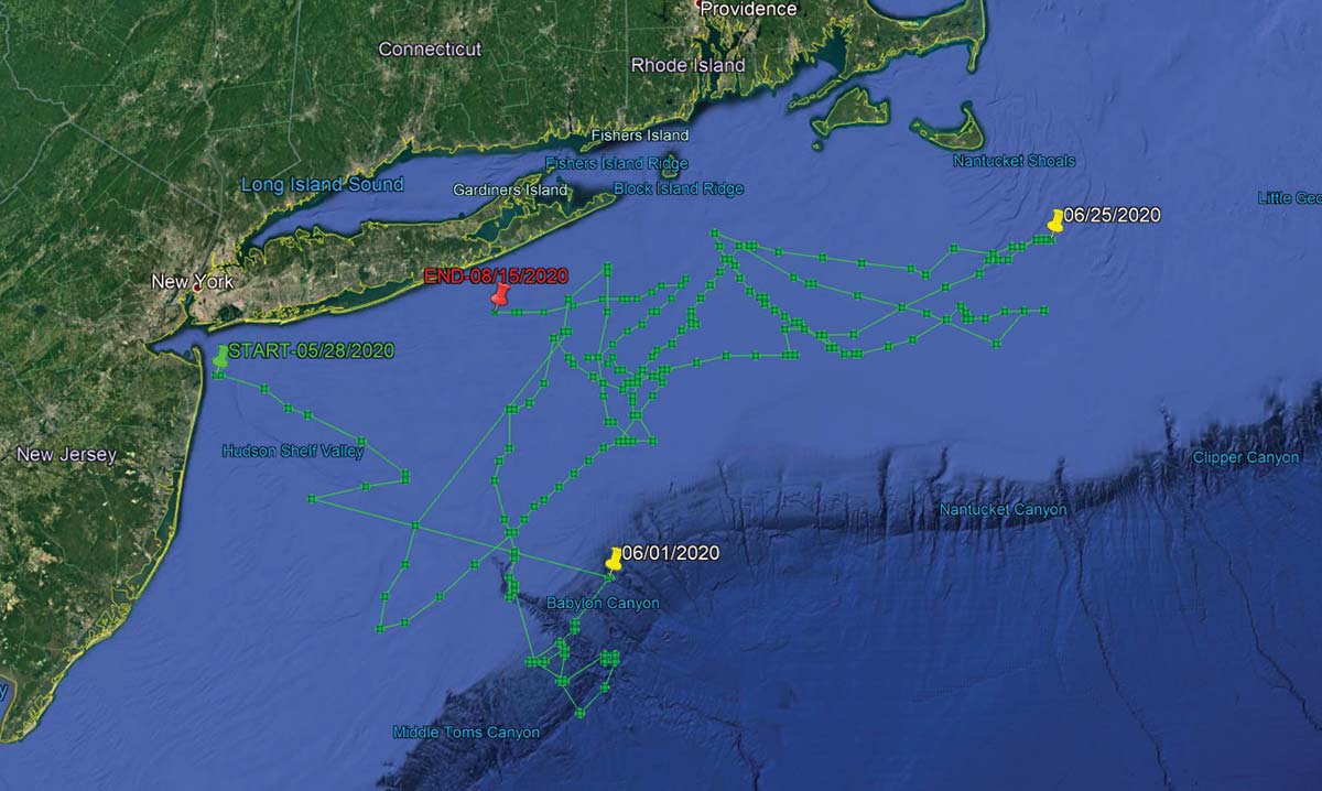
On August 1, 2020, the Argos satellite first began to receive information from Cora’s tag in roughly 650 feet of water some 30 miles offshore of Gloucester, MA in an area southeast of Jeffreys Ledge along the Murray Basin. According to the information in the MiniPSAT device since uploaded to the satellites, Cora had spent the previous two weeks heading in an easterly direction toward Stellwagen Bank, traveling approximately 85 miles in 14 days from an offshore area home to the Davis and Rodgers basins in the Gulf of Maine. That big striper was along the west side of George’s Bank for the July Fourth weekend, following a bit of meandering above Hydrographer Canyon.
As unbelievable as it may be for some us to believe that final month of travel, the route to actually get to George’s Bank was even more shocking. Cora, a 45-3/4-inch striper tagged on June 3, 2020 off Sandy Hook during the spring run, seemingly took a southeast route soon after her release, following a similar path to overseas freighters coming in and out of New York Harbor using the Hudson Canyon to Ambrose Channel deepwater lanes. By June 10, MiniPSAT data shows Cora down past the Chicken Canyon and not far from the Texas Tower, where she would eventually begin tracking northeast towards Nantucket Shoals over a 14-day period before turning north in between Martha’s Vineyard and Nantucket by June 25.
For about three weeks, Cora was outside of 3 miles and essentially unavailable to fishing pressure, and her return inshore in late June didn’t last very long either. During the final days of June Cora had cruised back through Nantucket Shoals before running that final offshore gauntlet in July. Anglers along the south shore of Long Island never got a shot at this 35-pounder. We don’t know where she was in the days leading up to her tagging on June 3, nor do we know where she is now, but we have a pretty solid idea about where she was for 53 days this summer, and it wasn’t near the 3-mile-line along the south shore of Long Island.
While Cora was the second big striper tagged for the 2020 Northeast Striped Bass Study – sister Rona being first on May 28 in the same stretch of water 2-1/2 miles east of Sandy Hook – her tag was the first to prematurely pop off. According to Bill Dobbelaer, president of Gray FishTag Research, there are any number of reasons why these highly specialized tags may come free.
“That fish could’ve gone under a piece of wood and it got hung up and tore loose…the answer is there are endless opportunities for that tag to come off,” Dobbelaer said, adding “it’s more of a miracle that it stays on, and the amount of information that we’ve already gotten from these fish is amazing. Dobbelaer and the Gray FishTag Research team have been involved in countless deployments around the globe with billfish where tags sometimes pop free within days of the initial capture.
“It sucks when it comes off two days after we let them go, which happens,” he said.
Tag Return #2
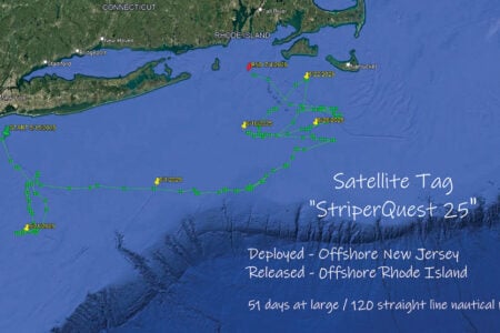
And then there was Rona. The first of three hefty stripers tagged in 2020 – Independence coming over the July Fourth weekend off Montauk – Rona was also tagged aboard Chuck Many’s Tyman on May 28, and her tag would begin relaying information from roughly 2 miles outside Moriches Inlet off Long Island on August 21.
When you look at the chart images of the travels taken by each of these fish, the first thing to understand is that the detailed tracking is not as exact as running on your own onboard GPS. There are quite literally millions of data points collected inside of these MiniPSAT devices bobbing along the Atlantic Ocean somewhere after coming undone from their host. As the Argos satellite passes overhead, the tag transmits its data where it is ultimately gathered by researchers at Gray. The data is then analyzed and input into charts to provide a general idea of migratory paths.
“We must always remember that fish in the ocean or wild never swim in a straight line,” said Dobbelaer, explaining “graphs created are averages based upon light sensors, temperature, and depth information.” The graphs are reviewed by the folks at Wildlife Computers in Redmond, WA and the Northeast Striped Bass Study team; at that point, the estimated path of the fish is broken down using the Navionics Boating App with my own Capt. Segull’s charts scattered across the office floor. Essentially, trying to pinpoint a fish’s precise path is like plotting a navigational course.
“They typically transmit for 10 days until the battery dies,” said Roxanne Willmer from Gray FishTag Research explaining how anywhere from 17,000 to 20,000 transmission attempts from the MiniPSAT devices to the overhead satellites once they’ve detached from the fish and floated to the surface. In 2019, both tagging devices were returned after being found on beaches along the Striper Coast, which is what researchers hope happens in 2020 as well. “If we do find them on a beach in three months then we can plug them in, which doesn’t require the battery, and get all of the data, maybe a more defined tracking,” Willmer said.
Heading back to the nautical charts with Navionics App in hand, we set to plotting Rona’s course from date of deployment off the Jersey Shore until the tag began to transmit 85 days later. As difficult as it was for any one of us to process – and as hard as it might be for readers to believe – that big fish also traveled southeast along the Hudson Shelf Valley after being tagged, swimming approximately 100 nautical miles to the tip of the Hudson Canyon over the course of just 4 days.
“Likelihood” is a common word used in science; based on the best available science, there’s always a probability or chance of something occurring or not occurring in nature, especially when inserting man into the equation. And from the data stored in that MiniPSAT device attached by fishermen into Rona at the beginning of the June, the tracking data showed the likelihood that she was finally on her way towards Moriches Inlet later that month after swimming around the edge of the Hudson and Toms. It would appear that Rona did swim back and forth across the line off Long Island at some point, but data fed to the Argos satellite shows a lot of ground covered over the span of a few weeks before making her northeastern-most stop along Nantucket Shoals by June 25, at roughly the same time as Cora.
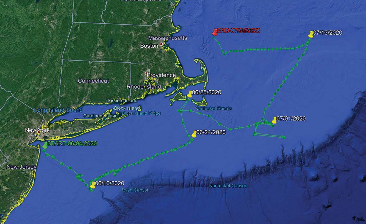
And similar to Cora which traversed darn close to the Texas Tower, data shows Rona making a quick run southwest of the Hudson tip in the area around the Triple Wrecks where yellowfin action was completely off the charts in 2020 with pelagics gorging on sand eels and keeping rods bent through early fall. On the move again in a northerly direction, Rona then covers a lot of ground south of Shinnecock at offshore areas during the summer as well, not far from where the Coimbra and Ranger wreck sites were ripe with life in 2020, and at roughly the same time.
“What is surprising is the magnitude of the apparent movements of these fish into offshore waters,” said John A. Tiedemann, Assistant Dean in the School of Science at Monmouth University and a longtime striped bass researcher and surfcaster. Tiedemann said he’s gone through 50 years of scientific research without finding any real evidence of such a long range offshore migration; he also noted how there’s never been a satellite tagging effort like this either.
“In terms of their range offshore, the striped bass is typically characterized as a nearshore coastal fish and very few life history accounts provide evidence of movements onto the outer continental shelf region,” said Tiedemman, adding “Further analysis of environmental data associated with the movements of these fish may shed light on whether they are moving offshore in response to water temperature, food availability, or simple wanderlust.”
Connect The Dots
Where Cora and perhaps a few of her compatriots continued east/northeast, Rona’s satellite tracking shows her cruising back towards Montauk, maintaining an offshore route and crisscrossing her earlier travels until the tag was released somewhere outside of Moriches. Whether she’s still swimming today or was brought to market is anyone’s guess. But as with all of the striped bass fit with MiniPSAT devices, there’s also a green streamer tag affixed to every fish to hopefully gather data on the final stats of each striper tagged. That’s all part of an even bigger effort to get more of the public involved on this collaborative work.
“It is our team’s mission in our tagging work to always keep the data collected as open access to all,” Dobbelaer said of the team’s research, adding “We will only conclude on the tagged specimen that we are studying, assume nothing of other fish movements or patterns, and continue to look for ways to evolve our own model.”
One of those ways is through the use of the green spaghetti tags that have been distributed this season to handful of local charter captains, and which hopefully can be integrated into even more widespread use by anglers in the future science of striped bass. Dobbelaer said that the Gray FishTag Research goal is to expand on their tagging model to gather data from thousands of tagged stripers from the Mid-Atlantic and Northeast, and hopefully using telemetry tagging with a robust spaghetti tag effort to not only track mortality and migration, but to better understand this offshore anomaly.
“It is shocking in a short period of time the speed and distance in which these fish traveled. This information is so contrary to what we all have been told,” Dobbelaer said throwing in yet another $10,000 question. “So, what do we do with this astounding information and where do we go from here?”
Tiedemman said that although individual striped bass exhibit variable rates of transit, it’s been well established they can move considerable distances in short periods of time. “For example, a fish we acoustically tagged on June 7, 2019 in Sandy Hook Bay was detected off Montauk less than a month later on July 3,” he said, adding “a study published in 2014 documented a striper moving from Delaware Bay to coastal waters off Massachusetts in just 9 days.”
Although the number of fish tagged in Northeast Striped Bass Study is still small and thus far only conducted with spring deployments, Tiedemman said it appears to be providing new information on spring and summer movements of larger bass in the region, adding “As the number of satellite tags deployed increases the data yielded by this effort will become more complete and robust.”
Again, are we seeing a pattern? Probably too soon to tell, which is why the Northeast Striped Bass Study will continue with support from the fishing community. And on July 3, our team deployed a third MiniPSAT device for 2020 in a 46-inch striper named Independence somewhere between the Porgy Hump and Pollock Rip off Montauk.
Furthermore, our team is hoping to be back in action in October for yet another expedition somewhere off Gloucester, MA with Wicked Tuna skipper Dave Marciano in hopes of finding another jumbo to perhaps connect a few more of the striper dots. As of this writing, we again wait with baited breath.