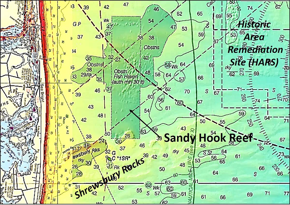
A bathymetric snapshot of New Jersey’s northernmost artificial reef site.
The Sandy Hook area crossed my career path a few times. The last time Ed Koch was Mayor of New York City, and I was directing the Coast Guard’s New York Harbor Vessel Traffic Service. He and I were participating in a crewboat demonstration ride for a proposed high-speed commuter ferry service from Atlantic Highlands to lower Manhattan.
Some years before, I had served on a special assignment with the U.S. Army Corps of Engineers (USACE) at the agency’s Washington, D.C. Headquarters. One morning, what is best described as a desperation call from the Coast Guard District in New York, was routed to me. During installation of underground communication wires for the Sandy Hook Station, a commercial backhoe operator stuck a large object. Seeing a bomb in the hole, the operator immediately departed without turning off the backhoe!
The bomb was on Coast Guard land for which the Corps of Engineers formerly held title. I was the Coast Guard guy at the Corps national headquarters, and the District expected me to get the Army to clean it up! It wasn’t my lookout, but the call put me on the hot seat, and proactive engagement was appropriate. Drawing on the expertise of the Corps headquarters staff, we put the District in contact with an Army explosive ordnance demolition team to resolve the immediate threat. We also determined the process necessary for unexploded ordnance (UXO) cleanup support and passed instructions to guide a formal Coast Guard request.
Preparing the Corps of Engineers response to proposed Federal ocean dumping monitoring regulations was another of my tasks. It was necessary to research ocean dumping off the New Jersey North Coast. There was a history of dropping dredged materials from hopper barges before reaching the designated dump site. The effect of dumped contaminated materials on marine species was also a hot issue. Eventually, the Historic Area Remediation Site (HARS) was established at the former ocean dump site and contaminated materials were capped with clean sediment. New Jersey and New York artificial reefs benefitted from the Corps of Engineers need for alternate places to dispose of rock from harbor dredging projects. Thus, “rock mountains” became the major reef structures in the Sandy Hook Fish Haven.
NJ’s First Reef
Fish haven shapes usually take a geometric form – square, rectangle, parallelogram, triangle, or circle, although sometimes with minor variations. Highly irregular form is atypical. Sandy Hook Reef’s permitted boundary follows the standard practice of geometric form. Shown as rectangular in the New Jersey reef program guide, the permitted fish haven is plotted on government charts as a very slight parallelogram. It’s one of the oldest artificial reefs in the system, dating from 1984.
The National Oceanic and Atmospheric Administration’s (NOAA) Bathymetric Data Viewer or BDV (maps.ngdc.noaa.gov/viewers/bathymetry) displays an entirely different situation than permitted criteria. Overlaying a see-through raster nautical chart onto the BDV “BAG” Color Shaded Relief image, a side-scan sonar-like picture shown in CHART 1, reveals extensive ocean dumping deposits east and west of the permitted reef site.
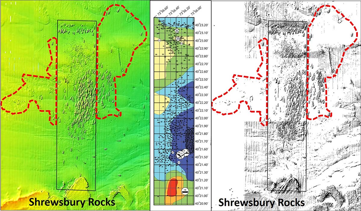
With the history of ocean dumping as the backdrop, finding hopper barge dumps outside the fish haven boundary wasn’t a surprise. The extent of the deposits was a surprise. None of this material is listed in reef program documentation. Yet, the outside-the-boundary placements are charted as if they are part of the artificial reef! CHART 2 includes processed versions of the sonar image and grid layout drawing from the New Jersey reef guide that highlights the bottom structure.
Where artificial materials are found in proximity to a fish haven but outside a permitted fish haven boundary, NOAA’s practice is to administratively add fish haven sections, sometimes retaining sounding data. That’s how the area around Sandy Hook Reef is charted. NOAA essentially threw a figurative lasso around most, but not all, outside-the-boundary deposits. This chart correction did not change the permit status, undoubtingly a contributing factor as to why the materials are not shown in the reef guide.
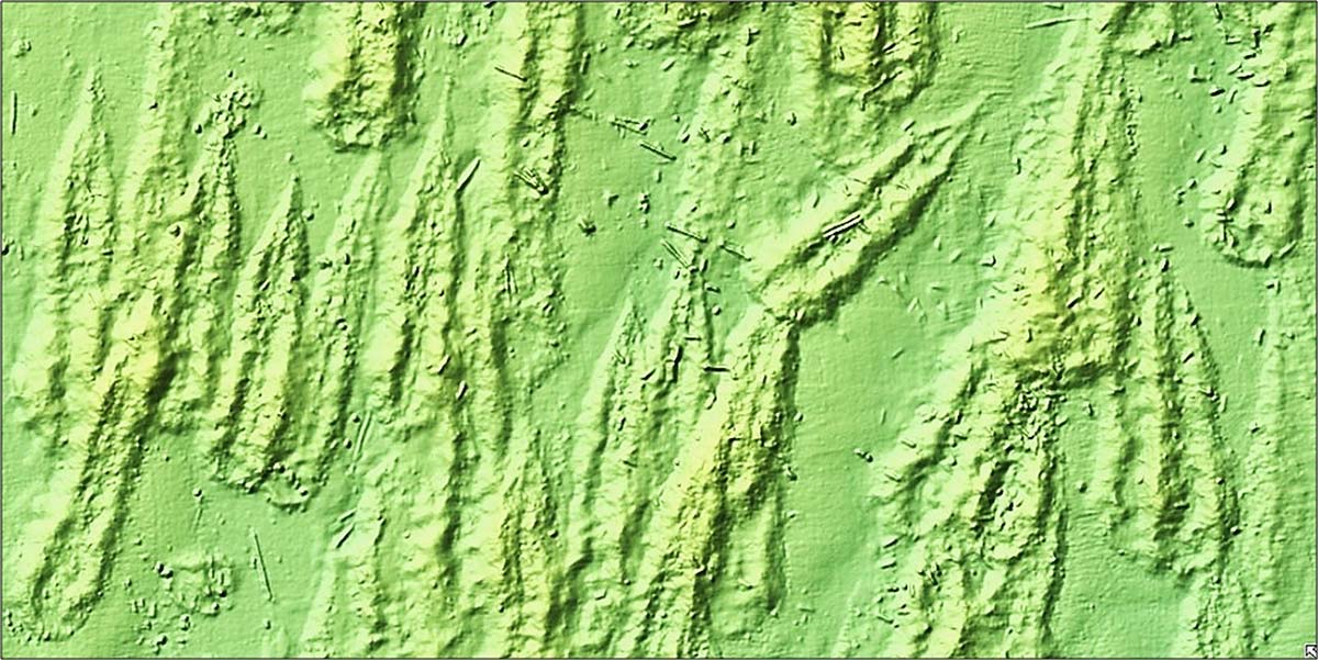
Much of the reef material is probably associated with two major harbor dredging projects, one in the early 1980s and the other in the early 1990s. Anecdotally, reef development is said to date from 1937. Many “short drops” of rock, cellar excavations (gravel and rock), and concrete demolition materials that predate the modern reef system are also suggested. Nevertheless, the location, orientation, and configuration of individual reefs suggest that much, if not all, of the outside deposits consist of dredged rock that were intended for the permitted reef. The BDV sonar images show that the rocks were deposited in a massive smear reef pattern. The hopper barges moved into the site from the northeast. It appears that deployments started on the west side of rock field from north to south with successive rows laid to the east.
A Detailed Analysis
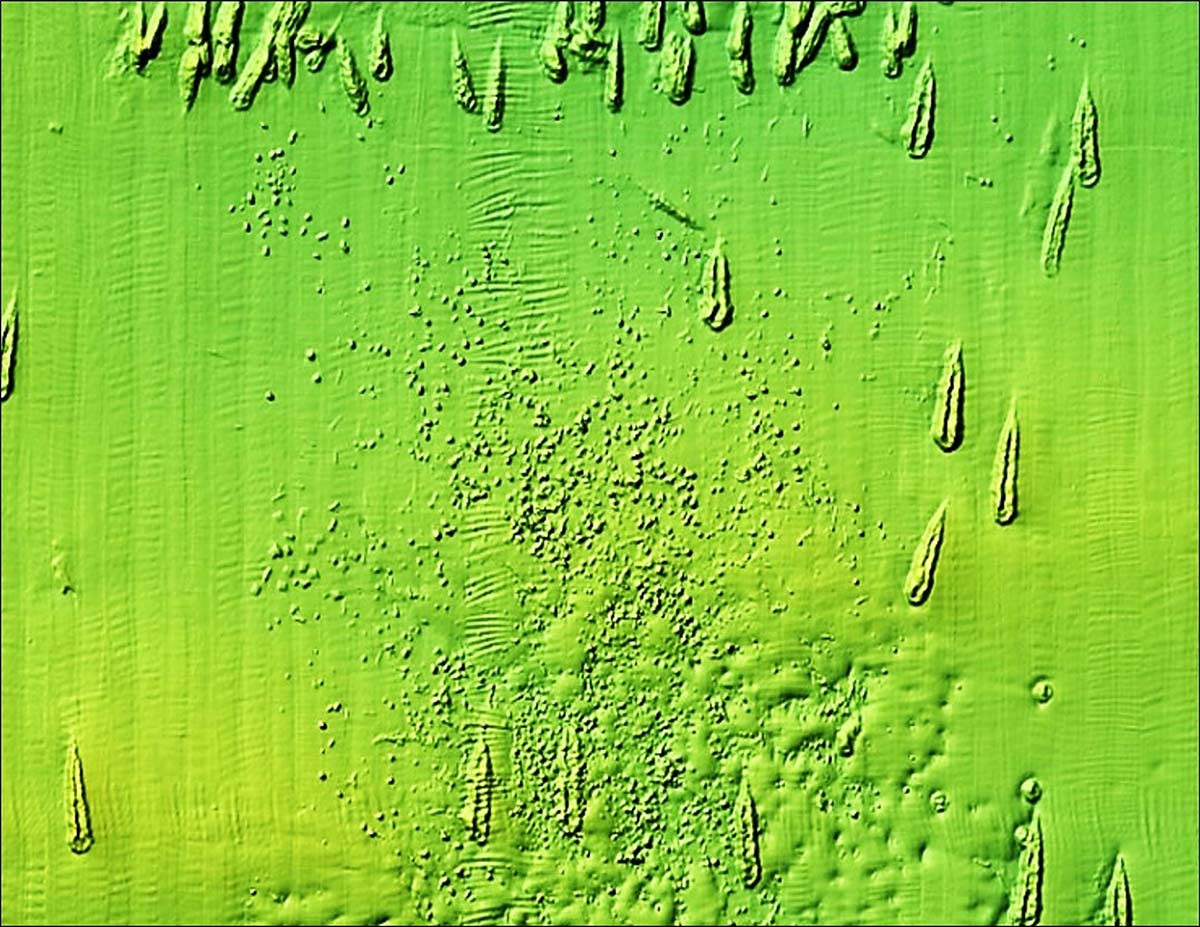
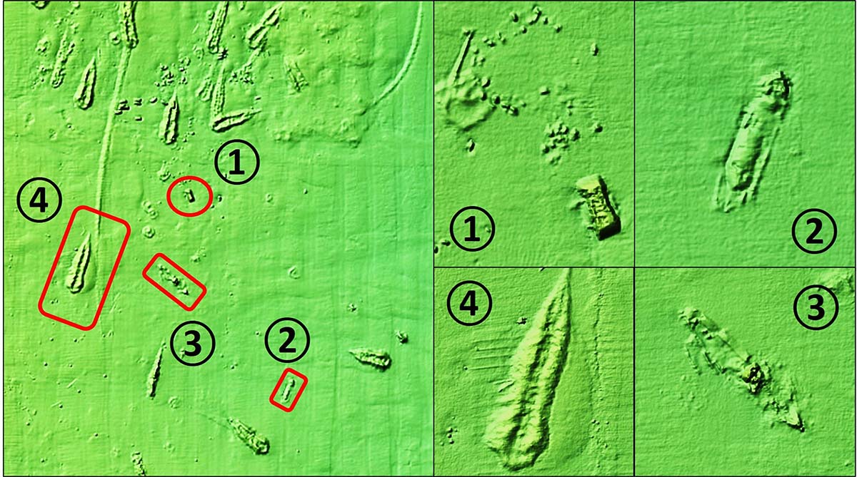
Teardrop-shaped formations shown in CHART 3 are typical of rocks and rubble dropped from hopper barges or scows. Each drop started at the pointy end of the teardrop as the deployment vessel moved forward. Dumping ended with a big plop as the last material in the barge let go. Some deposits were on top of earlier placements, creating greater vertical relief. The fish haven also has a lot of concrete castings and other materials. A broad field of concrete castings is in the upper third of the site south of the rock mountains that run east-west across the north end, as shown in CHART 4. The castings start as patch reefs that meld into a dense smear reef.
Wreckage inside a fish haven may be accidental or vessels that were intentionally placed as artificial reefs. The reef grid shows three vessels sunk as reefs and four wrecks that predate the site. A 65-foot tug, the Vinik Huntress, was added in June 2020, at coordinates 40-21.541N 73-56.006W. This puts the new reef just east of Reef #16-89, the 65-foot tug Dorothy. Some wrecks inside the site may have been buried by the rock deposits. Wrecks found outside the boundary are actual marine casualties.
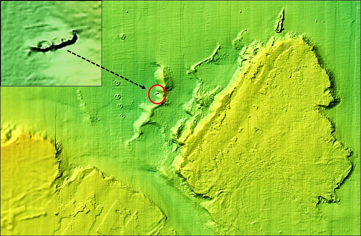
There are four objects that could be vessels. The three shown in CHART 5 are in the lower third of the site. A fourth vessel shown in CHART 6, is an uncharted wreck located on the north edge of the Shrewsbury Rocks formation which juts north into the south end of the fish haven. The wreck isn’t listed in the reef guide, although there may have been deposits after the guide was prepared. This rugged, highly irregular natural formation offers great fishing potential.
Extensive material deposits and sunken vessels in most of New Jersey’s artificial reefs have greatly expanded biological carrying capacity where there were unremarkable bottoms before. The result is a conundrum of excessive choice for recreational fishermen. Sandy Hook Reef is certainly no exception. The illustrations are a starting point for scouting the reef.
The BDV “BAG” Color Shaded Relief images provide a key resource to better appreciate this powerhouse fishing reef. There’s so much material, sportfish could be anywhere. Even using side-scan sonar when prospecting for sweet spots, exploring the full extent of reef deposits could take days. With so much structure, deciding where to fish is challenging. What a problem to have!
Wayne Young is a former manager of the Maryland artificial reef program for Chesapeake Bay waters. He is the author of “Chesapeake Bay Fishing Reefs: Voyages of Rediscovery” available on Amazon.com. His Facebook page is Chesapeake Bay Fishing Reefs. Charts and bathymetry images are processed screenshots from the National Oceanic and Atmospheric Administration’s Bathymetric Data Viewer.