Early results from a coastwide acoustic tagging study on striped bass.
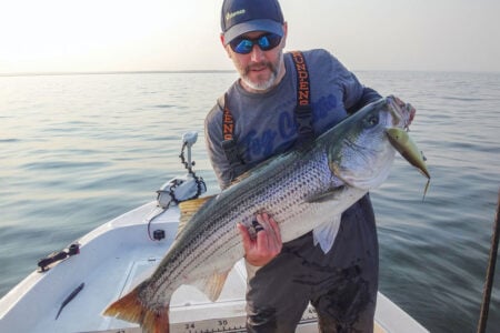
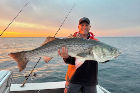
We rounded the tip of Sandy Hook on Chuck Manny’s TYMAN at dawn in pea soup fog. The crew consisted of myself, my Monmouth University colleagues Dr. Keith Dunton and his Research Assistant Nick Piscitelli, Nick Spadavecchia of Tak Waterman, Chuck, and his fishing partner Bobby Bodan.
Knowing Chuck’s specialty in catching big stripers, we were stoked to have a chance to fish with him. Our goal was to add some big bass to our acoustic tagging efforts and this trip did not disappoint! Once situated about a mile off the beach, Chuck meticulously set out multiple rods. His years of knowledge and hours on the chase allow him to set the baits with scientific precision. And, from the time he set out those baits, it was game on!
Technology Recap
As described in my September 2024 article in The Fisherman Magazine called Unblinded by Science: Gliders, Biotelemetry & Striper DNA over the past several decades acoustic telemetry has emerged as a powerful tool enabling a better understanding of coastal fish movements, migration patterns, and habitat use.
To review, here’s how it works – acoustic telemetry uses sound (acoustics) to relay information across open space (telemetry). For fisheries research, an acoustic telemetry system consists of two main pieces of equipment, transmitters and receivers. Transmitters are electronic tags that are surgically implanted in a fish’s body cavity. Each transmitter emits a unique series of sound pulses (pings) that are heard by underwater receivers making it possible to identify individual fish.

Receivers are data-logging listening devices that detect the sound signal of the tagged fish. The receiver decodes the unique signal of the tag and logs the transmitter number, date, and time of detection. By deploying an array of receivers in coastal waters scientists are able to track a fish’s movement when it comes within roughly 500 meters (tag detection range may vary with environmental conditions), as well as show the amount of time a fish spends in a particular area. Data on tagged fish detections are periodically downloaded from receivers, entered into a database and uploaded for researchers to review and analyze.
Dr. Dunton likes to equate acoustic tagging to an EZ Pass system for fish, allowing the precise tracking of movements of individual fish for up to 10 years. Dunton notes that the capability of this technique is made more powerful by the fact that researchers conducting telemetry tagging studies along the Atlantic Coast share data on tagged fish as part of a collaborative network known as the Atlantic Cooperative Telemetry Network or ACT (theactnetwork.com). The ACT network currently consists of over 200 scientists from North Carolina to Maine as well as researchers from the Canadian Maritimes. The ACT network database currently has 3,546 receiver stations throughout the Mid-Atlantic and northeast region.

Tracking Striper Movements
For several years we have been implanting acoustic tags in striped bass in coastal waters of the northern New York Bight in collaboration with local charter boats, fishing clubs, and conservation-minded striped bass anglers to yield more complete data on their habitat use, local movements, migratory travels, and residency patterns.
In 2024 and 2025 for example we deployed over 100 acoustic tags in stripers caught in the Hudson-Raritan Estuary and northern New Jersey and western Long Island coastal waters fishing with the captain and crew on the charter boat Kill Shot which runs out of Atlantic Highlands Municipal Marina on the Raritan Bay in New Jersey.
In addition, between 2020 and 2023, we implanted transmitters in 29 stripers caught at Island Beach State Park by anglers participating in the Berkeley Striper Club annual fall tagging weekend. Sizes of the fish tagged with the Berkeley club at Island Beach ranged from 18 to 33 inches, with a majority (75%) between 20 and 25 inches. As of spring 2025, we had over 100,000 total detections for these fish between our receiver arrays and arrays deployed by other researchers in the ACT tagging network.

Our run on the TYMAN in May 2024 yielded 16 bigger stripers that were implanted with acoustic tags. Sizes of the fish tagged on the TYMAN ranged 37.5 inches to 48 inches, with the majority (70%) over 44 inches. During their initial 8 months at large from May to December of 2024 we had over 16,000 detections of those bass between our receiver arrays and arrays deployed by other researchers in the ACT tagging network.
Overall, the striped bass we have tagged followed well-established migratory routes with many individuals generally moving along similar routes and exhibiting consistent timing of their movements during their migratory forays. Typically, sometime in spring they travel from southern points north along the New Jersey coast, then east along the south shore of Long Island to summer off various portions of the New England coast.
Once reaching northern waters in summer, some fish stay local in a particular area for extended periods of time, while others are a bit more mobile and wander between areas of suitable habitat. In fall, roughly the same migratory corridors are followed as the fish move away from New England waters and back west along the south shore of Long Island to overwinter off southern New Jersey or farther south in the Mid-Atlantic.
The farthest north any of our tagged fish have been detected to date is off the coast of Maine and the farthest south includes several fish being detected in Delaware Bay, off the Delaware and Maryland coasts, and in Chesapeake Bay.

Our acoustic telemetry tags will continue to yield information about a variety of aspects of striped bass life history and migratory behavior into the next decade. Tracking stripers with this technology also provides valuable data for assessing the potential impacts of projects underway or planned for the continental shelf in the northeast and Mid- Atlantic on migratory striped bass.
For example, analyzed over time at an appropriate spatial scale, scientists and managers can utilize these data to better understand how selection of future sand mining sites for beach replenishment, selection of new nearshore dredged material disposal sites, and siting and construction of offshore energy structures and their associated coastal infrastructure could disrupt striped bass movements, habitat use, and other environmental factors critical to their well-being.
The maps accompanying this article were prepared by Dr. Keith Dunton and Nick Piscitelli of Monmouth University to provide examples of tracking data for select fish tagged on our outings with the Berkeley Striper Club and on the TYMAN.
Berkeley Striper Club Maps

Striped Bass A69-9001-13468 is a 23.2-inch striped bass tagged with the Berkeley Striper Club on December 6, 2020 at Island Beach State Park. Generalizing across its 5 years at large, January through March is spent off the coasts of Delaware and southern New Jersey. This fish then moves north along the New Jersey coast from Delaware and east along the Long Island south shore spending April off the Rockaways before continuing east and reaching Montauk, then Rhode Island by late spring.
May to September detections are split between Montauk, Block Island, the Rhode Island coast and, in several years, southern Maine. For instance, 2021, 2023 and 2024 have this fish going up to Maine, while 2022 has this fish spending the summer off Rhode Island and Block Island. Fall is spent moving from northern New England back to the Connecticut and Rhode Island area before heading west along the south shore of Long Island with November detections concentrated around the Rockaways and Long Beach.
By winter, this fish heads south along the New Jersey coast spending time off southern New Jersey before winding up off of Delaware again.

Striped Bass A69-9001-13483 is a 20.1-inch striped bass tagged with the Berkeley Striper Club on December 7, 2021 at Island Beach State Park. Generalizing across its 4 years at large, this fish exhibited very consistent movement patterns between Delaware and Cape Cod, Massachusetts. Winters are spent off of Delaware before moving from the Delaware coast to the New Jersey coast in March. March to May is subsequently spent moving north along the New Jersey coast and east along the south shore of Long Island to Montauk, Block Island, then to the Connecticut and Rhode Island coasts before heading toward Cape Cod. Summers are subsequently spent around southern Cape Cod.
Although there are limited detections from August through October from the inshore receivers, in November this fish briefly moves offshore from Cape Cod to Nantucket, then back inshore to the Rhode Island and Connecticut coasts and eventually west along the south shore of Long Island. After moving south along the New Jersey coast in December, the fish is detected again off of Delaware.

Striped Bass A69-9001-57631 is a 28.7-inch striped bass tagged with the Berkeley Striper Club on December 2, 2022 at Island Beach State Park. Generalizing across its 3 years at large, this fish generally followed a similar movement pattern across all years. January and February is spent off the coast of Delaware. March is subsequently spent moving from the Delaware coast north along the New Jersey coast and, after spending some time in Raritan Bay, east along the south shore of Long Island to Montauk in April and May.
June through September finds this fish moving between the Connecticut and Rhode Island coasts and west of Martha’s Vineyard. In October and November, it moves back west along the Long Island south shore, spending time in the Rockaway and Long Beach area before it moves down the New Jersey coast in December. In winter, this fish eventually winds up off of Delaware again.
Notes:
- Data points depicted on these maps are a composite of all detections along the routes described over the fish’s time at large as of spring 2025.
- Time periods or geographic stretches with no detections represent times when a fish is swimming outside of locations with receiver arrays.
Tyman Maps

Striped Bass A69-9001-49991 is a 44.8-inch striped bass tagged aboard TYMAN on May 6, 2024 off Sandy Hook, NJ. After release, this fish spent the remainder of May in Raritan Bay. After moving out of Raritan Bay, June was spent moving east along the south shore of Long Island, past Montauk and then to the mouth of Narragansett Bay. Although there were no detections in August, September detections all took place at the mouth of Narragansett Bay and around Block Island. October and November find this fish moving back west along the south shore of Long Island and eventually south along New Jersey being detected off southern New Jersey in November. After that, there were no additional detections through December 2024.

Striped Bass A69-9001-49993 is a 46.5 inch striped bass tagged aboard TYMAN on May 6, 2024 off Sandy Hook. After release, this fish spent the remainder of May as well as early June in Raritan Bay before moving to the south shore of Long Island around the Rockaways and Long Beach. It then continued moving east along the south shore of Long Island, eventually spending some of June and July through September off Block Island. In late September, it moved back west along Long Island’s south shore reaching the northern New Jersey coast in October. After that, there were no additional detections through December 2024.

Striped Bass A69-9001-49994 is a 45.6 inch striped bass tagged on the TYMAN on May 6, 2024 off Sandy Hook. After release, this fish briefly moved into Raritan Bay before quickly moving east along the south shore of Long Island reaching Shinnecock Bay by the end of May. June through September was spent off the coast of southern Maine. By October it had moved back down the New England coast from Maine and into eastern Long Island Sound spending time in October and November off Connecticut and Rhode Island before heading west along the south shore of Long Island and back to the New Jersey coast, eventually ending up in Delaware Bay in December.
Notes:
- Data points depicted on these maps represent detections during the first year at-large for fish tagged on the TYMAN for the time period May 2024 through December 2024.
- Time periods or geographic stretches with no detections represent times when a fish is swimming outside of locations with receiver arrays.
The author recently retired as assistant dean of the School of Science at Monmouth University in New Jersey where he has specialized in marine ecology, coastal zone management, environmental science, marine recreational fisheries, and marine and environmental education.